Fresnedoso de Ibor
aus Wikipedia, der freien Enzyklopädie
| Gemeinde Fresnedoso de Ibor | |||
|---|---|---|---|
 Fresnedoso de Ibor | |||
| Wappen | Karte von Spanien | ||

|
| ||
| Basisdaten | |||
| Land: | |||
| Autonome Gemeinschaft: | |||
| Provinz: | Cáceres | ||
| Comarca: | Navalmoral de la Mata | ||
| Gerichtsbezirk: | Navalmoral de la Mata | ||
| Koordinaten: | 39° 41′ N, 5° 31′ W | ||
| Höhe: | 471 msnm | ||
| Fläche: | 54,66 km² | ||
| Einwohner: | 262 (1. Jan. 2022)[1] | ||
| Bevölkerungsdichte: | 5 Einw./km² | ||
| Postleitzahl(en): | 10328 | ||
| Gemeindenummer (INE): | 10075 | ||
| Verwaltung | |||
| Bürgermeister: | Casto San Roman Fernandez | ||
| Website: | Fresnedoso de Ibor | ||
| Lage des Ortes | |||
Karte anzeigen  | |||

Fresnedoso de Ibor ist ein spanischer Ort und eine Gemeinde (municipio) mit insgesamt 262 Einwohnern (Stand: 1. Januar 2022) in der Provinz Cáceres in der Autonomen Gemeinschaft Extremadura.
Lage und Klima
[Bearbeiten | Quelltext bearbeiten]Fresnedoso de Ibor liegt im Osten der Provinz Cáceres in einer Höhe von ca. 470 m. Die Entfernung zur Hauptstadt Cáceres beträgt ca. 80 km (Fahrtstrecke) in westsüdwestlicher Richtung. Das Klima ist meist warm und trocken; der eher spärliche Regen (726 mm/Jahr) fällt hauptsächlich im Winterhalbjahr.[2]
Bevölkerungsentwicklung
[Bearbeiten | Quelltext bearbeiten]| Jahr | 1970 | 1981 | 1991 | 2001 | 2011 | 2021 |
| Einwohner | 805 | 568 | 504 | 344 | 317 | 265[3] |
Die zunehmende Mechanisierung der Landwirtschaft, die Aufgabe bäuerlicher Kleinbetriebe („Höfesterben“) und die daraus resultierende Arbeitslosigkeit auf dem Land haben seit den 1950er Jahren zu einem deutlichen Rückgang der Einwohnerzahlen geführt.
Sehenswürdigkeiten
[Bearbeiten | Quelltext bearbeiten]- Antoniuskirche (Iglesia de San Antonio Abad)
-
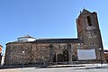 Antoniuskirche
 -
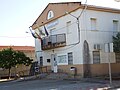 Rathaus
.jpg)

Weblinks
[Bearbeiten | Quelltext bearbeiten]Einzelnachweise
[Bearbeiten | Quelltext bearbeiten]- ↑ Cifras oficiales de población de los municipios españoles en aplicación de la Ley de Bases del Régimen Local (Art. 17). Instituto Nacional de Estadística (Bevölkerungsstatistiken des Instituto Nacional de Estadística, Stand 1. Januar 2022).
- ↑ Fresnedoso de Ibor - Klimatabellen
- ↑ Fresnedoso de Ibor – Bevölkerungsentwicklung
Abadía | Abertura | Acebo | Acehúche | Aceituna | Ahigal | Alagón del Río | Albalá | Alcántara | Alcollarín | Alcuéscar | Aldea del Cano | La Aldea del Obispo | Aldeacentenera | Aldeanueva de la Vera | Aldeanueva del Camino | Aldehuela de Jerte | Alía | Aliseda | Almaraz | Almoharín | Arroyo de la Luz | Arroyomolinos | Arroyomolinos de la Vera | Baños de Montemayor | Barrado | Belvís de Monroy | Benquerencia | Berrocalejo | Berzocana | Bohonal de Ibor | Botija | Brozas | Cabañas del Castillo | Cabezabellosa | Cabezuela del Valle | Cabrero | Cáceres | Cachorrilla | Cadalso | Calzadilla | Caminomorisco | Campillo de Deleitosa | Campo Lugar | Cañamero | Cañaveral | Carbajo | Carcaboso | Carrascalejo | Casar de Cáceres | Casar de Palomero | Casares de las Hurdes | Casas de Don Antonio | Casas de Don Gómez | Casas de Millán | Casas de Miravete | Casas del Castañar | Casas del Monte | Casatejada | Casillas de Coria | Castañar de Ibor | Ceclavín | Cedillo | Cerezo | Cilleros | Collado | Conquista de la Sierra | Coria | Cuacos de Yuste | La Cumbre | Deleitosa | Descargamaría | Eljas | Escurial | Fresnedoso de Ibor | Galisteo | Garciaz | La Garganta | Garganta la Olla | Gargantilla | Gargüera de la Vera | Garrovillas de Alconétar | Garvín | Gata | El Gordo | La Granja | Guadalupe | Guijo de Coria | Guijo de Galisteo | Guijo de Granadilla | Guijo de Santa Bárbara | Herguijuela | Hernán-Pérez | Herrera de Alcántara | Herreruela | Hervás | Higuera | Hinojal | Holguera | Hoyos | Huélaga | Ibahernando | Jaraicejo | Jaraíz de la Vera | Jarandilla de la Vera | Jarilla | Jerte | Ladrillar | Logrosán | Losar de la Vera | Madrigal de la Vera | Madrigalejo | Madroñera | Majadas de Tiétar | Malpartida de Cáceres | Malpartida de Plasencia | Marchagaz | Mata de Alcántara | Membrío | Mesas de Ibor | Miajadas | Millanes | Mirabel | Mohedas de Granadilla | Monroy | Montánchez | Montehermoso | Moraleja | Morcillo | Navaconcejo | Navalmoral de la Mata | Navalvillar de Ibor | Navas del Madroño | Navezuelas | Nuñomoral | Oliva de Plasencia | Palomero | Pasarón de la Vera | Pedroso de Acim | Peraleda de la Mata | Peraleda de San Román | Perales del Puerto | Pescueza | La Pesga | Piedras Albas | Pinofranqueado | Piornal | Plasencia | Plasenzuela | Portaje | Portezuelo | Pozuelo de Zarzón | Pueblonuevo de Miramontes | Puerto de Santa Cruz | Rebollar | Riolobos | Robledillo de Gata | Robledillo de la Vera | Robledillo de Trujillo | Robledollano | Romangordo | Rosalejo | Ruanes | Salorino | Salvatierra de Santiago | San Martín de Trevejo | Santa Ana | Santa Cruz de la Sierra | Santa Cruz de Paniagua | Santa Marta de Magasca | Santiago de Alcántara | Santiago del Campo | Santibáñez el Alto | Santibáñez el Bajo | Saucedilla | Segura de Toro | Serradilla | Serrejón | Sierra de Fuentes | Talaván | Talaveruela de la Vera | Talayuela | Tejeda de Tiétar | Tiétar | Toril | Tornavacas | El Torno | Torre de Don Miguel | Torre de Santa María | Torrecilla de los Ángeles | Torrecillas de la Tiesa | Torrejón el Rubio | Torrejoncillo | Torremenga | Torremocha | Torreorgaz | Torrequemada | Trujillo | Valdastillas | Valdecañas de Tajo | Valdefuentes | Valdehúncar | Valdelacasa de Tajo | Valdemorales | Valdeobispo | Valencia de Alcántara | Valverde de la Vera | Valverde del Fresno | Viandar de la Vera | Vegaviana | Villa del Campo | Villa del Rey | Villamesías | Villamiel | Villanueva de la Sierra | Villanueva de la Vera | Villar de Plasencia | Villar del Pedroso | Villasbuenas de Gata | Zarza de Granadilla | Zarza de Montánchez | Zarza la Mayor | Zorita
Text is available under the CC BY-SA 4.0 license; additional terms may apply.
Images, videos and audio are available under their respective licenses.
