Distrikt Nepeña
aus Wikipedia, der freien Enzyklopädie
| Distrikt Nepeña | |||
|---|---|---|---|
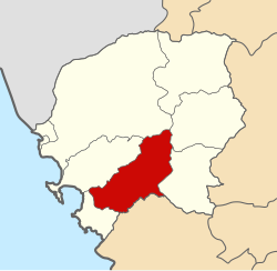
 Lage des Distrikts in der Provinz Santa | |||
| Symbole | |||
| |||
| Basisdaten | |||
| Staat | Peru | ||
| Region | Ancash | ||
| Provinz | Santa | ||
| Sitz | Nepeña | ||
| Fläche | 458,2 km² | ||
| Einwohner | 14.324 (2017) | ||
| Dichte | 31 Einwohner pro km² | ||
| Gründung | 12. April 1873 | ||
| ISO 3166-2 | PE-ANC | ||
| Politik | |||
| Alcalde Distrital | Pedro Nicolás Carranza López (2019–2022) | ||
| Partei | Movimiento Independiente Regional Río Santa Caudaloso | ||
 | |||
Der Distrikt Nepeña ist einer von 9 Distrikten der Provinz Santa und liegt in der Region Ancash in West-Peru. Der 458,24 km² große Distrikt wurde am 12. April 1873 gegründet. Beim Zensus 2017 lebten 14.324 Einwohner im Distrikt Nepeña. Im Jahr 1993 lag die Einwohnerzahl bei 11.260, im Jahr 2007 bei 13.860. Verwaltungssitz ist die Kleinstadt Nepeña (1900 Einwohner). Daneben gibt es im Distrikt noch die wesentlich größere Stadt San Jacinto (8400 Einwohner). Urbane Ortschaften im Distrikt sind San José (1400 Einwohner) und Cerro Blanco (820 Einwohner).
Der Distrikt Nepeña liegt etwa 30 km südöstlich der Großstadt Chimbote im Hinterland der Pazifikküste im Süden der Provinz Santa. Er erstreckt sich über die aride Küstenebene und reicht im Osten bis an die Cordillera Negra heran. Der Mittellauf des Río Nepeña durchfließt den Distrikt in westsüdwestlicher Richtung. Das Flusswasser wird größtenteils zur Bewässerung der entlang des Flusslaufs gelegenen landwirtschaftlich genutzten Flächen abgezweigt. Die Landschaft ist ansonsten wüstenhaft. Der Distrikt Nepeña grenzt im Südwesten an den Distrikt Samanco, im Nordwesten an den Distrikt Nuevo Chimbote, im Norden an den Distrikt Chimbote, im Nordosten an den Distrikt Caceres del Perú, im Osten an den Distrikt Moro sowie im Süden an den Distrikt Casma (in der Provinz Casma). Die Nationalstraße 1N (Panamericana) verläuft entlang der westlichen Distriktgrenze.
Weblinks
[Bearbeiten | Quelltext bearbeiten]- Peru: Region Ancash (Provinzen und Bezirke) bei www.citypopulation.de
Text is available under the CC BY-SA 4.0 license; additional terms may apply.
Images, videos and audio are available under their respective licenses.


