Datei:C71192s1 Ant.Map Ebbe Glacier.jpg
aus Wikipedia, der freien Enzyklopädie
Größe dieser Vorschau: 643 × 600 Pixel. Weitere Auflösungen: 257 × 240 Pixel | 515 × 480 Pixel | 823 × 768 Pixel | 1.098 × 1.024 Pixel | 2.196 × 2.048 Pixel | 3.507 × 3.271 Pixel
Originaldatei (3.507 × 3.271 Pixel, Dateigröße: 1,71 MB, MIME-Typ: image/jpeg)
![]()
Diese Datei und die Informationen unter dem roten Trennstrich werden aus dem zentralen Medienarchiv Wikimedia Commons eingebunden.
![]()
Beschreibung
| Beschreibung |
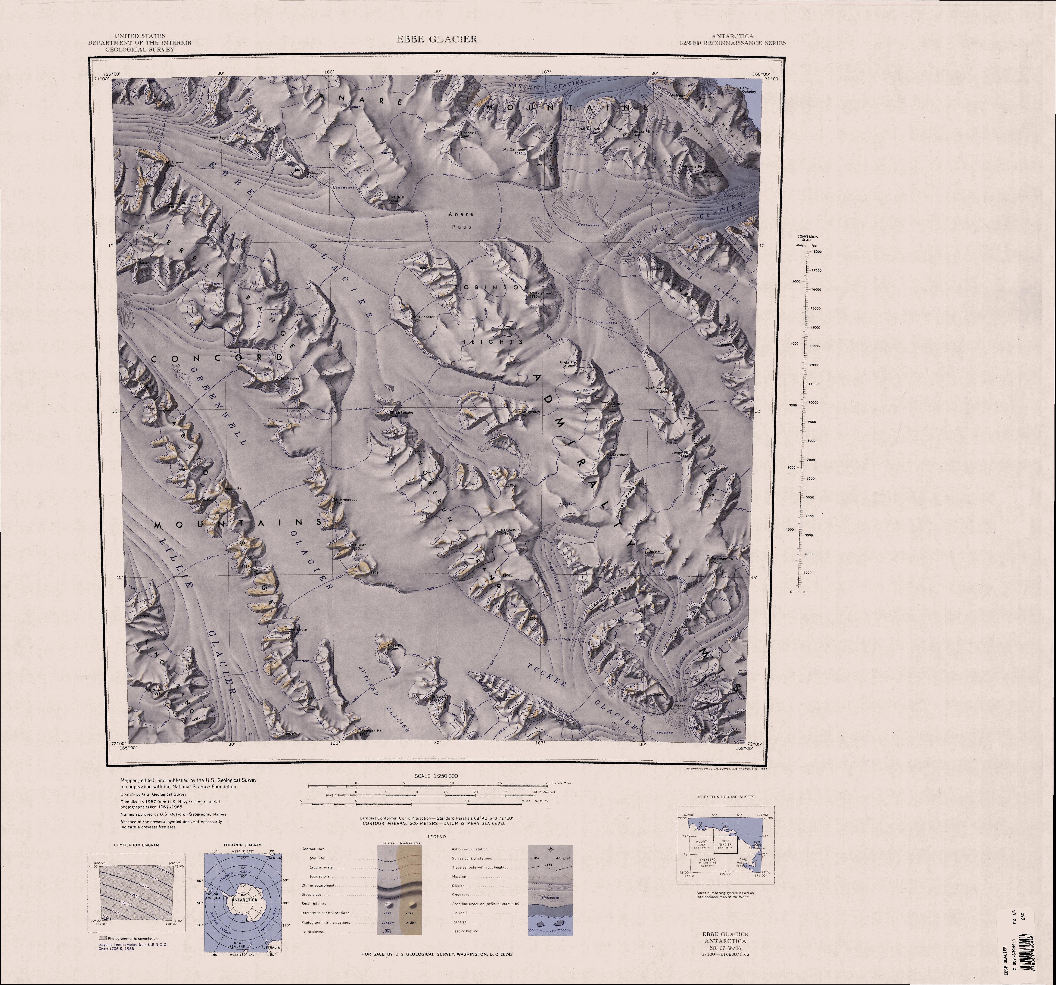
English: 1:250,000-scale topographic reconnaissance map of the Ebbe Glacier area in the Admiralty Range from 165°-168°E to 71°-72°S in Antarctica, including Greenwell, Lillie and Tucker Glacier. Mapped, edited and published by the U.S. Geological Survey in cooperation with the National Science Foundation. |
|||
| Datum | ||||
| Quelle | http://usarc.usgs.gov/drg_dload.shtml | |||
| Urheber | United States Geological Survey | |||
| Genehmigung (Weiternutzung dieser Datei) |
|
Dateiversionen
Klicke auf einen Zeitpunkt, um diese Version zu laden.
| Version vom | Vorschaubild | Maße | Benutzer | Kommentar | |
|---|---|---|---|---|---|
| aktuell | 22:31, 3. Apr. 2005 | | 3.507 × 3.271 (1,71 MB) | Achim Raschka | Map of Antarctica by the United States Antarctic Ressource Center of the US Geological Society. ((PD-US)) Copyrights and Trademarks USGS-authored or produced data and information are in the public domain. While the content of most USGS web pages is in th |
Dateiverwendung
Die folgenden 15 Seiten verwenden diese Datei:
Globale Dateiverwendung
Die nachfolgenden anderen Wikis verwenden diese Datei:
- Verwendung auf bg.wikipedia.org
- Verwendung auf ceb.wikipedia.org
- Verwendung auf en.wikipedia.org
- Admiralty Mountains
- Dennistoun Glacier
- Everett Range
- Lyttelton Range
- Dunedin Range
- Homerun Range
- Anare Mountains
- Lillie Glacier
- Concord Mountains
- Mirabito Range
- King Range (Antarctica)
- Tucker Glacier
- Victory Mountains
- Quam Heights
- Barnett Glacier
- Findlay Range
- Hedgpeth Heights
- Robinson Heights
- McGregor Range (Antarctica)
- Verwendung auf he.wikipedia.org
- Verwendung auf it.wikipedia.org
- Monti dell'Ammiragliato
- Ghiacciaio Greenwell
- Ghiacciaio Ebbe
- Dorsale Lyttelton
- Dorsale Homerun
- Cime Robinson
- Dorsale Dunedin
- Ghiacciaio Rastorfer
- Monti della Concordia
- Ghiacciaio Atkinson
- Ghiacciaio Dennistoun
- Ghiacciaio Church
- Ghiacciaio Leander
- Ghiacciaio Cracktrack
- Ghiacciaio Lann
- Ghiacciaio Rowles
- Monti ANARE
- Ghiacciaio Robertson
- Dorsale Mirabito
- Dorsale Everett
- Dorsale King
- Verwendung auf nn.wikipedia.org
- Verwendung auf no.wikipedia.org
- Verwendung auf pl.wikipedia.org
- Verwendung auf www.wikidata.org
Weitere globale Verwendungen dieser Datei anschauen.
Metadaten
Text is available under the CC BY-SA 4.0 license; additional terms may apply.
Images, videos and audio are available under their respective licenses.
Cover photo is available under {{::mainImage.info.license.name || 'Unknown'}} license.
Cover photo is available under {{::mainImage.info.license.name || 'Unknown'}} license.
Credit:
(see original file).
