Bradford County (Pennsylvania)
aus Wikipedia, der freien Enzyklopädie
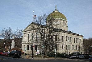
 Bradford County Courthouse | |
| Verwaltung | |
|---|---|
| US-Bundesstaat: | Pennsylvania |
| Verwaltungssitz: | Towanda |
| Adresse des Verwaltungssitzes: |
Bradford County, PA 301 Main Street Towanda, PA 18848 |
| Gründung: | 1810 |
| Gebildet aus: | Luzerne County Lycoming County |
| Vorwahl: | 001 570 |
| Demographie | |
| Einwohner: | 59.967 (Stand: 2020) |
| Bevölkerungsdichte: | 20,12 Einwohner/km2 |
| Geographie | |
| Fläche gesamt: | 3007 km² |
| Wasserfläche: | 27 km² |
| Karte | |
 | |
| Website: www.bradfordcountypa.org | |
Bradford County[1] ist ein County im Bundesstaat Pennsylvania der Vereinigten Staaten. Bei der Volkszählung im Jahr 2020 hatte das County 59.967[2] Einwohner und eine Bevölkerungsdichte von 20 Einwohner pro Quadratkilometer. Der Verwaltungssitz (County Seat) ist Towanda.
Geschichte
[Bearbeiten | Quelltext bearbeiten]Das County wurde am 21. Februar 1810 mit der Bezeichnung Ontario County gebildet. Am 24. März 1812 erfolgte die Umbenennung auf den heutigen Namen, der an den Juristen und Politiker William Bradford erinnert.[3]
15 Bauwerke und Stätten des Countys sind im National Register of Historic Places (NRHP) eingetragen (Stand 20. Juli 2018).[4]
Geographie
[Bearbeiten | Quelltext bearbeiten]Das County hat eine Fläche von 3007 Quadratkilometern, wovon 27 Quadratkilometer Wasserfläche sind. Bradford County grenzt im Osten an Susquehanna County, im Südosten an Wyoming County, im Süden an Sullivan County, im Südwesten an Lycoming County, im Westen an Tioga County und im Norden an den Bundesstaat New York.
Städte und Ortschaften
[Bearbeiten | Quelltext bearbeiten]
| Bevölkerungsentwicklung | |||
|---|---|---|---|
| Census | Einwohner | ± rel. | |
| 1900 | 59.403 | — | |
| 1910 | 54.526 | −8,2 % | |
| 1920 | 53.166 | −2,5 % | |
| 1930 | 49.039 | −7,8 % | |
| 1940 | 50.615 | 3,2 % | |
| 1950 | 51.722 | 2,2 % | |
| 1960 | 54.925 | 6,2 % | |
| 1970 | 57.962 | 5,5 % | |
| 1980 | 62.919 | 8,6 % | |
| 1990 | 60.967 | −3,1 % | |
| 2000 | 62.761 | 2,9 % | |
| 2010 | 62.622 | −0,2 % | |
| 2020 | 59.967 | −4,2 % | |
| 1900–1990[5]
2000[6] | |||
|
|
|
Einzelnachweise
[Bearbeiten | Quelltext bearbeiten]- ↑ Bradford County. In: Geographic Names Information System. United States Geological Survey, United States Department of the Interior (englisch).. Abgerufen am 22. Februar 2011
- ↑ Explore Census Data Total Population in Bradford County, Pennsylvania. Abgerufen am 24. März 2023.
- ↑ Charles Curry Aiken, Joseph Nathan Kane: The American Counties: Origins of County Names, Dates of Creation, Area, and Population Data, 1950–2010. 6. Auflage. Scarecrow Press, Lanham 2013, ISBN 978-0-8108-8762-6, S. 29.
- ↑ Suchmaske Datenbank im National Register Information System. National Park Service, abgerufen am 20. Juli 2018.
- ↑ Auszug aus Census.gov. Abgerufen am 28. Februar 2011
- ↑ Archivierte Kopie ( des vom 10. Februar 2020 im Webarchiv archive.today) Info: Der Archivlink wurde automatisch eingesetzt und noch nicht geprüft. Bitte prüfe Original- und Archivlink gemäß Anleitung und entferne dann diesen Hinweis. Abgerufen am 28. Februar 2011
Weblinks
[Bearbeiten | Quelltext bearbeiten]Koordinaten: 41° 47′ N, 76° 31′ W
Text is available under the CC BY-SA 4.0 license; additional terms may apply.
Images, videos and audio are available under their respective licenses.
