Blesa (Teruel)
aus Wikipedia, der freien Enzyklopädie
| Blesa | |||
|---|---|---|---|

| |||
| Wappen | Karte von Spanien | ||
.svg)
|
| ||
| Basisdaten | |||
| Land: | |||
| Autonome Gemeinschaft: | |||
| Provinz: | Teruel | ||
| Comarca: | Cuencas Mineras | ||
| Gerichtsbezirk: | Calamocha | ||
| Koordinaten: | 41° 3′ N, 0° 53′ W | ||
| Höhe: | 771 msnm | ||
| Fläche: | 80,39 km² | ||
| Einwohner: | 88 (1. Jan. 2022)[1] | ||
| Bevölkerungsdichte: | 1 Einw./km² | ||
| Postleitzahl(en): | 44790 | ||
| Gemeindenummer (INE): | 44043 | ||
| Verwaltung | |||
| Bürgermeister: | Joaquín Miguel Calvo Castro (PP) | ||
| Website: | Blesa | ||
| Lage der Stadt | |||
Karte anzeigen  | |||

Blesa ist eine spanische Gemeinde in der Provinz Teruel, die zur Autonomen Region Aragonien gehört. Sie ist Teil der Comarca (Kreis) Cuencas Mineras. Blesa hatte zum 1. Januar 2022 insgesamt 88 Einwohner.
Lage
[Bearbeiten | Quelltext bearbeiten]Blesa liegt circa 80 Kilometer nordnordöstlich der Provinzhauptstadt Teruel in einer Höhe von ca. 770 m.
Bevölkerungsentwicklung
[Bearbeiten | Quelltext bearbeiten]| Jahr | 1970 | 1981 | 1991 | 2001 | 2011 | 2021 |
| Einwohner | 358 | 215 | 165 | 139 | 127 | 86[2] |
Sehenswürdigkeiten
[Bearbeiten | Quelltext bearbeiten]- Kreuzkirche
- Zimmerer- und Schmiedemuseum
-
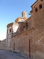 Kreuzkirche
 -
 Zimmerer- und Schmiedemuseum
 -
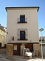
 Rathaus


Weblinks
[Bearbeiten | Quelltext bearbeiten]Einzelnachweise
[Bearbeiten | Quelltext bearbeiten]- ↑ Cifras oficiales de población de los municipios españoles en aplicación de la Ley de Bases del Régimen Local (Art. 17). Instituto Nacional de Estadística (Bevölkerungsstatistiken des Instituto Nacional de Estadística, Stand 1. Januar 2022).
- ↑ Blesa – Bevölkerungsentwicklung

Ababuj | Abejuela | Aguatón | Aguaviva | Aguilar del Alfambra | Alacón | Alba | Albalate del Arzobispo | Albarracín | Albentosa | Alcaine | Alcalá de la Selva | Alcañiz | Alcorisa | Alfambra | Aliaga | Allepuz | Alloza | Allueva | Almohaja | Alobras | Alpeñés | Anadón | Andorra | Arcos de las Salinas | Arens de Lledó | Argente | Ariño | Azaila | Bádenas | Báguena | Bañón | Barrachina | Bea | Beceite | Bello | Belmonte de San José | Berge | Bezas | Blancas | Blesa | Bordón | Bronchales | Bueña | Burbáguena | Cabra de Mora | Calaceite | Calamocha | Calanda | Calomarde | Camañas | Camarena de la Sierra | Camarillas | Caminreal | Cantavieja | Cañada de Benatanduz | La Cañada de Verich | Cañada Vellida | Cañizar del Olivar | Cascante del Río | Castejón de Tornos | Castel de Cabra | Castellote | Castelnou | Castelserás | Cedrillas | Celadas | Cella | Corbalán | Cortes de Aragón | Cosa | Cretas | Crivillén | Cubla | Cucalón | Cuevas de Almudén | Cuevas Labradas | Ejulve | El Pobo | El Castellar | El Cuervo | El Vallecillo | Escorihuela | Escucha | Estercuel | Ferreruela de Huerva | Fonfría | Formiche Alto | Fórnoles | Fortanete | Foz-Calanda | Frías de Albarracín | Fuenferrada | Fuentes Calientes | Fuentes Claras | Fuentes de Rubielos | Fuentespalda | Galve | Gargallo | Gea de Albarracín | Griegos | Guadalaviar | Gúdar | Híjar | Hinojosa de Jarque | Huesa del Común | Jabaloyas | Jarque de la Val | Jatiel | Jorcas | Josa | La Cerollera | La Codoñera | La Cuba | La Fresneda | La Ginebrosa | Lagueruela | La Hoz de la Vieja | La Iglesuela del Cid | La Mata de los Olmos | Lanzuela | La Portellada | La Puebla de Híjar | La Puebla de Valverde | Las Parras de Castellote | La Zoma | Libros | Lidón | Linares de Mora | Loscos | Los Olmos | Lledó | Maicas | Manzanera | Martín del Río | Mas de las Matas | Mazaleón | Mezquita de Jarque | Mirambel | Miravete de la Sierra | Molinos | Monforte de Moyuela | Monreal del Campo | Monroyo | Montalbán | Monteagudo del Castillo | Monterde de Albarracín | Mora de Rubielos | Moscardón | Mosqueruela | Muniesa | Noguera de Albarracín | Nogueras | Nogueruelas | Obón | Odón | Ojos Negros | Olba | Oliete | Orihuela del Tremedal | Orrios | Palomar de Arroyos | Pancrudo | Peñarroya de Tastavins | Peracense | Peralejos | Perales del Alfambra | Pitarque | Plou | Pozondón | Pozuel del Campo | Puertomingalvo | Ráfales | Rillo | Riodeva | Ródenas | Royuela | Rubiales | Rubielos de la Cérida | Rubielos de Mora | Salcedillo | Saldón | Samper de Calanda | San Agustín | San Martín del Río | Santa Cruz de Nogueras | Santa Eulalia del Campo | Sarrión | Segura de los Baños | Seno | Singra | Terriente | Teruel | Toril y Masegoso | Tormón | Tornos | Torralba de los Sisones | Torre de Arcas | Torre de las Arcas | Torre del Compte | Torre los Negros | Torrecilla de Alcañiz | Torrecilla del Rebollar | Torrelacárcel | Torremocha de Jiloca | Torres de Albarracín | Torrevelilla | Torrijas | Torrijo del Campo | Tramacastiel | Tramacastilla | Tronchón | Urrea de Gaén | Utrillas | Valacloche | Valbona | Valdealgorfa | Valdecuenca | Valdelinares | Valdeltormo | Valderrobres | Valjunquera | Veguillas de la Sierra | Villafranca del Campo | Villahermosa del Campo | Villanueva del Rebollar de la Sierra | Villar del Cobo | Villar del Salz | Villarluengo | Villarquemado | Villarroya de los Pinares | Villastar | Villel | Vinaceite | Visiedo | Vivel del Río Martín
Text is available under the CC BY-SA 4.0 license; additional terms may apply.
Images, videos and audio are available under their respective licenses.
