Bezirk Paphos
aus Wikipedia, der freien Enzyklopädie
| Επαρχία Πάφου Baf kazası
Bezirk Paphos | |
|---|---|
 | |
| Basisdaten | |
| Staat | Zypern |
| Hauptstadt | Paphos |
| Fläche | 1396 km² |
| Einwohner | 101.106 (2021[1]) |
| Dichte | 72 Einwohner pro km² |
| ISO 3166-2 | CY-05 |
| Webauftritt | www.moi.gov.cy (englisch) |
| Politik | |
| Regierungschef | Andreas S. Christodoulides |
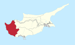
Der Bezirk Paphos ist ein Bezirk der Republik Zypern im Westen der Mittelmeerinsel Zypern. Der Bezirk ist in vier Stadtbezirke unterteilt: Paphos (Hauptort), Geroskipou, Pegia und Polis Chrysochous.[2] Weitere Dörfer sind z. B. Pano Akourdalia und Terra.
Der Bezirk Paphos ist der einzige Bezirk, auf den die Republik Zypern vollständig die Kontrolle ausübt.[3]
Geografie
[Bearbeiten | Quelltext bearbeiten]Der Bezirk Paphos liegt im westlichen Teil Zyperns. Im Osten grenzt es an den Bezirk Limassol und den Bezirk Nikosia.
Der Bezirk hat eine Fläche von 1396 km², entsprechend 15,09 % der Insel.[2] Die Küsten sind gekennzeichnet durch Buchten, Kaps und kleinere Halbinseln. So erstreckt sich im Westen des Bezirks die unbesiedelte und unter Schutz stehende Halbinsel Akamas, an der sich auch der westlichste Punkt Zyperns befindet. Fast die gesamte Nordküste liegt an der Bucht von Chrysochou. Der Bezirk ist in drei geographische Regionen unterteilt: die Küstenregion, die hügelige Region und die Gebirgsregion.
Gemeinden
[Bearbeiten | Quelltext bearbeiten]
Laut Statistischem Dienst der Republik Zypern besteht der Bezirk Paphos aus 4 Städten und 121 Gemeinden.[4] Städte sind fett dargestellt.
- Achelia
- Agia Marina Chrysochous
- Agia Marina Kelokedaron
- Agia Marinouda
- Agia Varvara
- Agios Dimitrianos
- Agios Georgios
- Agios Ioannis
- Agios Isidoros
- Agios Nikolaos
- Akoursos
- Amargeti
- Anadiou
- Anarita
- Androlikou
- Argaka
- Arminou
- Armou
- Asprogia
- Axylou
- Chlorakas
- Choletria
- Choli
- Choulou
- Chrysochou
- Drousia
- Drymou
- Eledio
- Emba
- Episkopi
- Evretou
- Falia
- Fasli
- Fasoula
- Filousa Chrysochous
- Filousa Kelokedaron
- Finikas
- Fyti
- Galataria
- Geroskipou
- Gialia
- Giolou
- Goudi
- Inia
- Kallepia
- Kannaviou
- Karamoullides
- Kathikas
- Kato Akourdalia
- Kato Arodes
- Kedares
- Kelokedara
- Kidasi
- Kili
- Kilinia
- Kios
- Kissonerga
- Konia
- Kouklia
- Kourdaka
- Kritou Marottou
- Kritou Tera
- Kynousa
- Lapithiou
- Lasa
- Lemona
- Lemba
- Letymvou
- Livadi
- Loukrounou
- Lysos
- Makounda
- Mamonia
- Mamountali
- Mandria
- Marathounda
- Maronas
- Meladia
- Melandra
- Mesa Chorio
- Mesana
- Mesogi
- Milia
- Miliou
- Mousere
- Nata
- Nea Dimmata
- Neo Chorio
- Nikoklia
- Pano Akourdalia
- Pano Archimandrita
- Pano Arodes
- Pano Panagia
- Paphos
- Pegia
- Pelathousa
- Pentalia
- Peristerona
- Pitargou
- Polemi
- Polis
- Pomos
- Prastio
- Pretori
- Psathi
- Salamiou
- Sarama
- Simou
- Skoulli
- Souskiou
- Statos-Agios Fotios
- Stavrokonnou
- Steni
- Stroumbi
- Tala
- Terra
- Theletra
- Thrinia
- Timi
- Trachypedoula
- Tremithousa
- Trimithousa
- Tsada
- Vretsia
- Zacharia
Einzelnachweise
[Bearbeiten | Quelltext bearbeiten]- ↑ Population Enumerated by Sex, Age, District and Municipality/Community 1.10.2021. Statistischer Dienst der Republik Zypern (CYSTAT), abgerufen am 5. September 2024 (englisch).
- ↑ a b Unterteilung und Fläche. Abgerufen am 8. August 2022 (englisch).
- ↑ Karte von Zypern und dessen Bevölkerungsgruppen, Grenzen und Gemeinden. Archiviert vom (nicht mehr online verfügbar) am 24. Februar 2012; abgerufen am 8. August 2022.
- ↑ GEO_CODES-2015 (Download, Excel)
Text is available under the CC BY-SA 4.0 license; additional terms may apply.
Images, videos and audio are available under their respective licenses.
