Bara (Distrikt)
aus Wikipedia, der freien Enzyklopädie
| बारा जिल्ला Distrikt Bara
| |
|---|---|
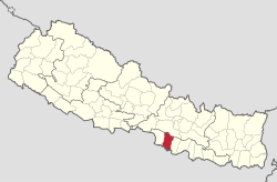
 Lage des Distriktes Bara (rot) in Nepal | |
| Basisdaten | |
| Staat | Nepal |
| Provinz | Madhesh |
| Sitz | Kalaiya |
| Fläche | 1190 km² |
| Einwohner | 687.708 (Volkszählung 2011) |
| Dichte | 578 Einwohner pro km² |
| ISO 3166-2 | NP-P2 |
 | |

Der Distrikt Bara (Nepali बारा जिल्ला) ist einer von 77 Distrikten in Nepal.
Der Bara-Distrikt liegt im Terai in der Verwaltungszone Narayani und grenzt im Süden an Indien.
Im Jahre 2001 hatte der Distrikt 559.135 Einwohner; 2011 waren es 687.708.[1]
Verwaltungsgliederung
[Bearbeiten | Quelltext bearbeiten]Im Distrikt Bara liegen folgende Städte:
Im Distrikt Bara liegen folgende Village Development Committees (VDCs):
- Amarpatti
- Amlekhganj
- Avab
- Bachhanpurba
- Badaki Phulbariya
- Bagadi
- Bahuari
- Balirampur
- Bandhuwan
- Banjariya
- Barainiya
- Barawa
- Basantpur
- Batara
- Beldari
- Benauli
- Bhagwanpur
- Bhaluyee Arwaliya
- Bhatauda
- Bhaudaha
- Bhuluhi Marwaliya
- Bishnupur
- Bishnupurba
- Bishrampur
- Biswambharpur
- Brahmapuri
- Buniyad
- Chhatawa
- Dewapur
- Dharma Nagar
- Dohari
- Gadhahal
- Haraiya
- Hardiya
- Inarwamal
- Inarwasira
- Itiyahi
- Jhitakaiya
- Kabahigoth
- Kabahijabdi
- Kachorwa
- Khopawa
- Khutwajabdi
- Kudawa
- Laxmipur Kotwali
- Lipanimal
- Madhurijabdi
- Mahendra Adarsha
- Maheshpur
- Maini
- Majhariya
- Manaharwa
- Matiarwa
- Motisar
- Naktuwa
- Narahi
- Pakadiya Chikani
- Paparpati Ek
- Paparpati Jabdi
- Parsurampur
- Paterwa
- Pathora
- Pheta
- Piparpati Dui
- Piparpati Parchrouwa
- Pipra Basantapur
- Piprabirta
- Pipradhi Goth
- Prasauni
- Prastoka
- Purainiya
- Raghunathpur
- Rampur Tokani
- Rampurwa
- Rauwahi
- Sihorwa
- Sinhasani
- Sisahaniya
- Srinagar Bairiya
- Tedhakatti
- Terariya
- Umarjan
Weblinks
[Bearbeiten | Quelltext bearbeiten]Einzelnachweise
[Bearbeiten | Quelltext bearbeiten]- ↑ Central Bureau of Statistics, Census 2011: National Report (S. 51–52, Population Total und Area in Sq. Km). ( vom 25. Mai 2013 im Internet Archive) (PDF; 7,8 MB)
Text is available under the CC BY-SA 4.0 license; additional terms may apply.
Images, videos and audio are available under their respective licenses.
