For faster navigation, this Iframe is preloading the Wikiwand page for Kreis Warendorf.

Kreis Warendorf

Warendorf
Våben Beliggenhed
Coat of arms of Warendorf
Tyskland, beliggenhed af Warendorf markeret
Administration
Land Tyskland Tyskland
Delstat Nordrhein-Westfalen
Admin. region Münster
Admin. by Warendorf
Lokal inddeling 13 kommuner
Statistiske data
Areal 1.319,41 km²
Indbyggere 277.783  (31/12/2018)
 - Tæthed 211 Indb./km²
Andre informationer
Tidszone CET/CEST (UTC+1/UTC+2)
Nummerplade WAF, BE
Websted www.kreis-warendorf.de
Beliggenhed af Warendorf
Lage des Kreis Warendorf in Nordrhein-Westfalen (anklickbare Karte)HollandBelgienNiedersachsenRheinland-PfalzHessenEssenWuppertalSolingenRemscheidHagenEnnepe-Ruhr-KreisBochumDortmundHerneGelsenkirchenBottropOberhausenMülheim an der RuhrDuisburgKreis MettmannDüsseldorfRhein-Kreis NeussKreis HeinsbergMönchengladbachKrefeldKreis ViersenKreis WeselKreis KleveRhein-Erft-KreisKreis DürenRheinisch-Bergischer KreisOberbergischer KreisKreis RecklinghausenKreis BorkenKreis UnnaMärkischer KreisKreis OlpeHammKreis SoestKreis CoesfeldKreis SteinfurtKreis WarendorfLeverkusenKölnStädteregion AachenBonnRhein-Sieg-KreisStädteregion AachenKreis EuskirchenMünsterKreis Siegen-WittgensteinHochsauerlandkreisKreis PaderbornKreis GüterslohKreis HöxterKreis LippeKreis HerfordKreis Minden-LübbeckeBielefeld
Lage des Kreis Warendorf in Nordrhein-Westfalen (anklickbare Karte)

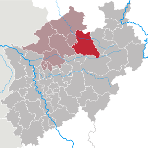
Kreis Warendorf ligger i regeringsdistriktet Münster i den tyske delstat Nordrhein-Westfalen. Nabodistrikten er Kreis Steinfurt, Landkreis Osnabrück, Landkreis Gütersloh, Kreis Soest, kreisfri by Hamm, Kreis Coesfeld og kreisfri by Münster.

Byer og kommuner

[redigér | rediger kildetekst]

Kreisen havde 277783 indbyggere pr. 2018-12-31

Bykommuner (Städte):

  1. Ahlen (52582)
  2. Beckum (36646)
  3. Drensteinfurt (15542)
  4. Ennigerloh (19829)
  5. Oelde (29326)
  6. Sassenberg (14260)
  7. Sendenhorst (13157)
  8. Telgte (19925)
  9. Warendorf (37226)

Landkommuner (Gemeinden):

  1. Beelen (6245)
  2. Everswinkel (9666)
  3. Ostbevern (10982)
  4. Wadersloh (12397)

Eksterne henvisninger

[redigér | rediger kildetekst]

Officielt websted

51°55′N 7°55′Ø / 51.92°N 7.92°Ø / 51.92; 7.92

{{bottomLinkPreText}} {{bottomLinkText}}
Kreis Warendorf
Listen to this article

This browser is not supported by Wikiwand :(
Wikiwand requires a browser with modern capabilities in order to provide you with the best reading experience.
Please download and use one of the following browsers:

This article was just edited, click to reload
This article has been deleted on Wikipedia (Why?)

Back to homepage

Please click Add in the dialog above
Please click Allow in the top-left corner,
then click Install Now in the dialog
Please click Open in the download dialog,
then click Install
Please click the "Downloads" icon in the Safari toolbar, open the first download in the list,
then click Install
{{::$root.activation.text}}

Install Wikiwand

Install on Chrome Install on Firefox
Don't forget to rate us

Tell your friends about Wikiwand!

Gmail Facebook Twitter Link

Enjoying Wikiwand?

Tell your friends and spread the love:
Share on Gmail Share on Facebook Share on Twitter Share on Buffer

Our magic isn't perfect

You can help our automatic cover photo selection by reporting an unsuitable photo.

This photo is visually disturbing This photo is not a good choice

Thank you for helping!


Your input will affect cover photo selection, along with input from other users.

X

Get ready for Wikiwand 2.0 🎉! the new version arrives on September 1st! Don't want to wait?