Allegany County (Maryland)
| Allegany County, Maryland | |
| Kort | |
 Placering i delstaten Maryland | |
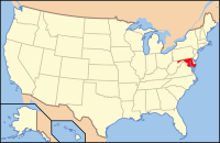
 Marylands placering i USA | |
| Basis data | |
| Grundlagt | 1789 |
|---|---|
| Hovedby | Cumberland |
| Areal - I alt - Land - Vand |
1.113 km² 1.102 km² 11 km² |
| Befolkningstal - år 2005 Befolkningstæthed |
73.639 68 indb/km² |
| Hjemmeside: gov.allconet.org | |
| Opkaldt efter: Et lokalt oprindeligt amerikansk ord, oolikhanna, som betyder "smukt vandløb." | |
 For alternative betydninger, se Allegany County. (Se også artikler, som begynder med Allegany County)
Allegany County er et county i den nordvestlige del af delstaten Maryland i USA med en befolkning i 2000 på 74.930. Hovedbyen er Cumberland. Navnet Allegany kommer fra et lokalt oprindeligt amerikansk ord, oolikhanna, som betyder "smukt vandløb." Et antal counties i bjergområdet Appalacherne i USA kaldes Allegany, Allegheny eller Alleghany.
Historie
[redigér | rediger kildetekst]Den vestlige del af Maryland (heriblandt det nuværende Allegany County) samledes i Prince George's County i 1696. Ved gentagne opsplitninger af dette, dannedes nye: Frederick i 1748 og Montgomery og Washington fra Frederick County i 1776.[1]
Allegany County dannedes i 1789 ved opdeling af Washington County. På det tidspunkt var det Marylands vestligste county, men en senere opdeling i 1872 dannede Garrett County, som nu er det vestligste.
Styre
[redigér | rediger kildetekst]Allegany County fik hjemmestyre i 1974.
Geografi
[redigér | rediger kildetekst]Ifølge den officielle opgørelse har Allegany County et samlet areal på 1.113 km², hvoraf 11 km² (1,02%) er vand.
Tilgrænsende counties
[redigér | rediger kildetekst]- Somerset County, Pennsylvania (nord)
- Bedford County, Pennsylvania (nord)
- Fulton County, Pennsylvania (nord)
- Washington County (øst)
- Morgan County, West Virginia (syd)
- Hampshire County, West Virginia (syd)
- Mineral County, West Virginia (syd)
- Garrett County (vest)
Bjerge
[redigér | rediger kildetekst]I Allegany County ligger følgende bjerge:
- Breakneck Hill (1,872 ft.)
- Collier Mountain (1,460 ft.)
- Dans Mountain (2,898 ft.)
- Evitts Mountain (1,959-2,260 ft.)
- Martin Mountain (1,974 ft.)
- Nicholas Mountain (1,760 ft.)
- Polish Mountain (1,783 ft.)
- Ragged Mountain (1,740 ft.)
- Town Hill (2,039 ft.)
- Warrior Mountain (2,185 ft.)
- Wills Mountain (1,960+ ft.)
- Haystack Mountain (1,240+ ft.)
- Irons Mountain
- Piney Mountain
Demografi
[redigér | rediger kildetekst]| Historisk befolkningstal | |||
|---|---|---|---|
| Tælling | Bef.tal | %± | |
| 1830 | 10.590 | ||
| 1850 | 22.799 | ||
| 1900 | 53.694 | ||
| 1910 | 62.411 | 16.2% | |
| 1920 | 69.938 | 12.1% | |
| 1930 | 79.098 | 13.1% | |
| 1940 | 86.973 | 10,0% | |
| 1950 | 89.556 | 3,0% | |
| 1960 | 84.169 | -6,0% | |
| 1970 | 84.044 | -0.1% | |
| 1980 | 80.548 | -4.2% | |
| 1990 | 74.946 | -7,0% | |
| 2000 | 74.930 | -0,0% | |
Byer
[redigér | rediger kildetekst]Byer i Allegany County med selvstændigt bystyre er
- Cumberland (bystyre fra 1815)
- Frostburg (bystyre fra 1839)
- Barton (bystyre fra 1900)
- Lonaconing (bystyre fra 1890)
- Luke (bystyre fra 1922)
- Midland (bystyre fra 1900)
- Westernport (bystyre fra 1858)
Kilder
[redigér | rediger kildetekst]Eksterne henvisninger
[redigér | rediger kildetekst]Text is available under the CC BY-SA 4.0 license; additional terms may apply.
Images, videos and audio are available under their respective licenses.
