Delwedd:Salween watershed.png
Maint y rhagolwg: 485 × 599 picsel. Eglurdebau eraill: 194 × 240 picsel | 500 × 618 picsel.
Maint llawn ((500 × 618 picsel, maint y ffeil: 113 KB, ffurf MIME: image/png))
Crynodeb
| Disgrifiad |
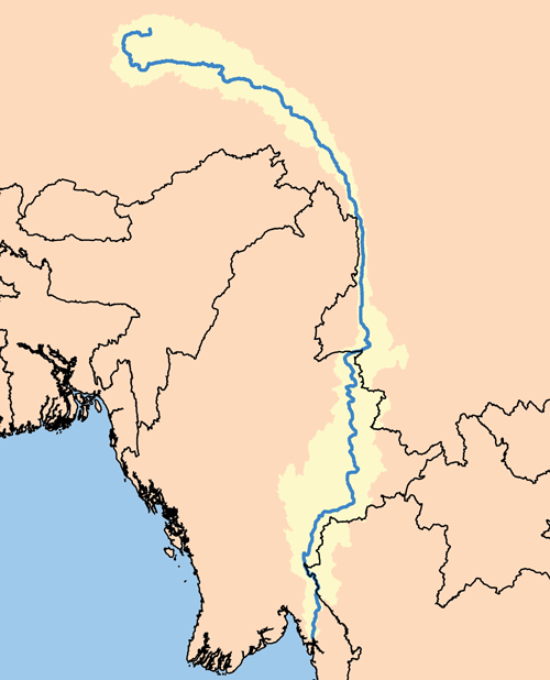
This is a map of the Salween River Watershed.
|
| Dyddiad | 30 Tachwedd 2005 (original upload date) |
| Ffynhonnell | No machine-readable source provided. Own work assumed (based on copyright claims). |
| Awdur | No machine-readable author provided. Kmusser assumed (based on copyright claims). |
Trwyddedu
Yr wyf fi, deiliad yr hawlfraint ar y gwaith hwn, yn ei gyhoeddi yn ôl termau'r drwydded a ganlyn:
Trwyddedir y ffeil hon yn ôl termau'r drwydded Creative Commons Attribution-Share Alike 2.5 Generic.
- Mae'n rhydd i chi:
- rhannu – gallwch gopïo, dosbarthu a throsglwyddo'r gwaith
- ailwampio – gallwch addasu'r gwaith
- Ar yr amodau canlynol:
- cydnabyddiaeth – Mae'n rhaid i chi nodi manylion y gwaith hwn, rhoi dolen i'r drwydded, a nodi os y bu golygu arni, yn y modd a benwyd gan yr awdur neu'r trwyddedwr (ond heb awgrymu o gwbl eu bod yn eich cymeradwyo chi na'ch defnydd o'r gwaith).
- rhannu ar dermau tebyg – Os byddwch yn addasu'r gwaith hwn, neu yn ei drawsnewid, neu yn adeiladu arno, mae'n rhaid i chi ddosbarthu'r gwaith dan drwydded sy'n union yr un fath same a'r gwreiddiol.
Hanes y ffeil
Cliciwch ar ddyddiad / amser i weld y ffeil fel ag yr oedd bryd hynny.
| Dyddiad / Amser | Bawdlun | Hyd a lled | Defnyddiwr | Sylw | |
|---|---|---|---|---|---|
| cyfredol | 19:10, 29 Medi 2010 | | 500 × 618 (113 KB) | Kmusser | increase resolution |
| 15:40, 30 Tachwedd 2005 |  | 162 × 200 (10 KB) | Kmusser | This is a map of the Salween River River Watershed. I, Karl Musser, created it based on USGS data. ((GFDL)) Category:Maps of rivers |
Cysylltiadau'r ffeil
Mae'r 1 tudalennau a ddefnyddir isod yn cysylltu i'r ddelwedd hon:
Defnydd cydwici y ffeil
Mae'r wicis eraill hyn yn defnyddio'r ffeil hon:
- Y defnydd ar af.wikipedia.org
- Y defnydd ar azb.wikipedia.org
- Y defnydd ar be.wikipedia.org
- Y defnydd ar blk.wikipedia.org
- Y defnydd ar bo.wikipedia.org
- Y defnydd ar cs.wikipedia.org
- Y defnydd ar da.wikipedia.org
- Y defnydd ar en.wikipedia.org
- Y defnydd ar es.wikipedia.org
- Y defnydd ar et.wikipedia.org
- Y defnydd ar fa.wikipedia.org
- Y defnydd ar fi.wikipedia.org
- Y defnydd ar fr.wikipedia.org
- Y defnydd ar ha.wikipedia.org
- Y defnydd ar hi.wikipedia.org
- Y defnydd ar hr.wikipedia.org
- Y defnydd ar it.wikipedia.org
- Y defnydd ar ky.wikipedia.org
- Y defnydd ar mk.wikipedia.org
- Y defnydd ar ml.wikipedia.org
- Y defnydd ar my.wikipedia.org
- Y defnydd ar nl.wikipedia.org
- Y defnydd ar no.wikipedia.org
- Y defnydd ar pa.wikipedia.org
- Y defnydd ar pl.wikipedia.org
- Y defnydd ar pl.wiktionary.org
- Y defnydd ar pt.wikipedia.org
- Y defnydd ar ru.wikipedia.org
- Y defnydd ar shn.wikipedia.org
- Y defnydd ar sr.wikipedia.org
- Y defnydd ar sv.wikipedia.org
- Y defnydd ar ta.wikipedia.org
- Y defnydd ar tr.wikipedia.org
- Y defnydd ar uk.wikipedia.org
- Y defnydd ar vi.wikipedia.org
- Y defnydd ar www.wikidata.org
Gweld rhagor o'r defnydd cydwici o'r ffeil hon.
Text is available under the CC BY-SA 4.0 license; additional terms may apply.
Images, videos and audio are available under their respective licenses.
Cover photo is available under {{::mainImage.info.license.name || 'Unknown'}} license.
Cover photo is available under {{::mainImage.info.license.name || 'Unknown'}} license.
Credit:
(see original file).
