For faster navigation, this Iframe is preloading the Wikiwand page for Warschauer Straße (stanice metra v Berlíně).

Warschauer Straße (stanice metra v Berlíně)

Warschauer Straße
Warschauer Straße
Warschauer Straße
StátNěmecko
MěstoBerlín
ČtvrťKreuzberg
UliceWarschauer Straße
Vznik17. září 1902
DopravceBVG
LinkyU1, U3
Technické informace
Typ stanicenadzemní (U1)
Počet nástupišť2
ArchitektPaul Wittig
Externí odkazy
Zeměpisné souřadnice
Map
Logo Wikimedia Commons multimediální obsah na Commons
Některá data mohou pocházet z datové položky.

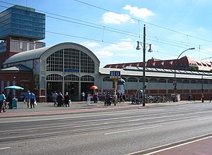
Warschauer Straße je přestupní stanice stanice metra a městských vlaků v Berlíně. Leží v městské části Friedrichshaim, pod mostem Warschauer Brücke. Nachází se na dopravní tepně Warschauer Straße, denně zde nastoupí cca 85 000 lidí.

Zakázku na výstavbu dostala firma Siemens und Halske, ujal se jí architekt Paul Wittig. Za druhé světové války byla stanice uzavřena a znovuotevřena byla 14. února 1945. Po rekonstrukci byla otevřena jako přestupní stanice metra a městských vlaků (S-Bahn). Roku 1991 zde byla nainstalována bronzová vlajka Varšavy, jako důkaz partnerství.

V tomto článku byl použit překlad textu z článku Bahnhof Berlin Warschauer Straße na německé Wikipedii.


Externí odkazy

[editovat | editovat zdroj]
← směr Warschauer Straße U-Bahn v Berlíně – linka U1 směr Uhlandstraße
Warschauer Straße Schlesisches Tor
Warschauer Straße   – Schlesisches Tor  – Görlitzer Bahnhof  – Kottbusser Tor   – Prinzenstraße  – Hallesches Tor   – Möckernbrücke   – Gleisdreieck   – Kurfürstenstraße  – Nollendorfplatz    – Wittenbergplatz   – Kurfürstendamm  – Uhlandstraße
← směr Warschauer Straße U-Bahn v Berlíně – linka U3 směr Krumme Lanke →
Warschauer Straße Schlesisches Tor
Warschauer Straße   – Schlesisches Tor  – Görlitzer Bahnhof  – Kottbusser Tor   – Prinzenstraße  – Hallesches Tor   – Möckernbrücke   – Gleisdreieck   – Kurfürstenstraße  – Nollendorfplatz    – Wittenbergplatz   – Augsburger Straße – Nürnberger Platz – Spichernstraße  – Hohenzollernplatz – Fehrbelliner Platz – Heidelberger Platz  – Rüdesheimer Platz – Breitenbachplatz – Podbielskiallee – Dahlem-Dorf – Freie Universität – Oskar-Helene-Heim – Onkel Toms Hütte – Krumme Lanke
{{bottomLinkPreText}} {{bottomLinkText}}
Warschauer Straße (stanice metra v Berlíně)
Listen to this article

This browser is not supported by Wikiwand :(
Wikiwand requires a browser with modern capabilities in order to provide you with the best reading experience.
Please download and use one of the following browsers:

This article was just edited, click to reload
This article has been deleted on Wikipedia (Why?)

Back to homepage

Please click Add in the dialog above
Please click Allow in the top-left corner,
then click Install Now in the dialog
Please click Open in the download dialog,
then click Install
Please click the "Downloads" icon in the Safari toolbar, open the first download in the list,
then click Install
{{::$root.activation.text}}

Install Wikiwand

Install on Chrome Install on Firefox
Don't forget to rate us

Tell your friends about Wikiwand!

Gmail Facebook Twitter Link

Enjoying Wikiwand?

Tell your friends and spread the love:
Share on Gmail Share on Facebook Share on Twitter Share on Buffer

Our magic isn't perfect

You can help our automatic cover photo selection by reporting an unsuitable photo.

This photo is visually disturbing This photo is not a good choice

Thank you for helping!


Your input will affect cover photo selection, along with input from other users.

X

Get ready for Wikiwand 2.0 🎉! the new version arrives on September 1st! Don't want to wait?