For faster navigation, this Iframe is preloading the Wikiwand page for Soubor:Iceland Mid-Atlantic Ridge Fig16.gif.

Soubor:Iceland Mid-Atlantic Ridge Fig16.gif

Iceland_Mid-Atlantic_Ridge_Fig16.gif(376 × 390 pixelů, velikost souboru: 9 KB, MIME typ: image/gif)

K tomuto obrázku existuje vektorová verze (v SVG). Pokud je lepší, používejte raději tu.

File:Iceland Mid-Atlantic Ridge Fig16.gif → File:Iceland Mid-Atlantic Ridge map.svg

Podrobnější informace o vektorové grafice najdete na stránce Commons:Transition to SVG.
Také si můžete přečíst informace o podpoře formátu SVG v MediaWiki.

V jiných jazycích
Alemannisch  Bahasa Indonesia  Bahasa Melayu  British English  català  čeština  dansk  Deutsch  eesti  English  español  Esperanto  euskara  français  Frysk  galego  hrvatski  Ido  italiano  lietuvių  magyar  Nederlands  norsk bokmål  norsk nynorsk  occitan  Plattdüütsch  polski  português  português do Brasil  română  Scots  sicilianu  slovenčina  slovenščina  suomi  svenska  Tiếng Việt  Türkçe  vèneto  Ελληνικά  беларуская (тарашкевіца)  български  македонски  нохчийн  русский  српски / srpski  татарча/tatarça  українська  ქართული  հայերեն  বাংলা  தமிழ்  മലയാളം  ไทย  한국어  日本語  简体中文  繁體中文  עברית  العربية  فارسی  +/−
Nový obrázek ve formátu SVG

Popis

Popis
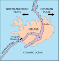
English: Map showing the Mid-Atlantic Ridge splitting Iceland and separating the North American and Eurasian Plates. The map also shows Reykjavik, the capital of Iceland, the Thingvellir area, and the locations of some of Iceland's active volcanoes (red triangles), including Krafla.
Datum
Zdroj pubs.usgs.gov
Autor USGS

Licence

Public domain
Tento soubor je volné dílo, protože obsahuje materiály pocházející od United States Geological Survey (USGS), agentury Ministerstva vnitra USA. Pro bližší informaci vizte oficiální licenční pravidla USGS (anglicky).

Bahasa Indonesia  català  čeština  Deutsch  eesti  English  español  français  galego  italiano  Nederlands  português  polski  sicilianu  suomi  Tiếng Việt  Türkçe  български  македонски  русский  മലയാളം  한국어  日本語  中文  中文(简体)  中文(繁體)  العربية  فارسی  +/−

Popisky

Přidejte jednořádkové vysvětlení, co tento soubor představuje

Položky vyobrazené v tomto souboru

zobrazuje

Historie souboru

Kliknutím na datum a čas se zobrazí tehdejší verze souboru.

Datum a časNáhledRozměryUživatelKomentář
současná10. 3. 2005, 01:02Náhled verze z 10. 3. 2005, 01:02376 × 390 (9 KB)Svart~commonswikiMap showing the Mid-Atlantic Ridge splitting Iceland and separating the North American and Eurasian Plates. The map also shows Reykjavik, the capital of Iceland, the Thingvellir area, and the locations of some of Iceland's active volcanoes (red triangles)

Využití souboru

Tento soubor používají následující 2 stránky:

Globální využití souboru

Tento soubor využívají následující wiki:

Zobrazit další globální využití tohoto souboru.

Metadata

{{bottomLinkPreText}} {{bottomLinkText}}
Soubor:Iceland Mid-Atlantic Ridge Fig16.gif
Listen to this article

This browser is not supported by Wikiwand :(
Wikiwand requires a browser with modern capabilities in order to provide you with the best reading experience.
Please download and use one of the following browsers:

This article was just edited, click to reload
This article has been deleted on Wikipedia (Why?)

Back to homepage

Please click Add in the dialog above
Please click Allow in the top-left corner,
then click Install Now in the dialog
Please click Open in the download dialog,
then click Install
Please click the "Downloads" icon in the Safari toolbar, open the first download in the list,
then click Install
{{::$root.activation.text}}

Install Wikiwand

Install on Chrome Install on Firefox
Don't forget to rate us

Tell your friends about Wikiwand!

Gmail Facebook Twitter Link

Enjoying Wikiwand?

Tell your friends and spread the love:
Share on Gmail Share on Facebook Share on Twitter Share on Buffer

Our magic isn't perfect

You can help our automatic cover photo selection by reporting an unsuitable photo.

This photo is visually disturbing This photo is not a good choice

Thank you for helping!


Your input will affect cover photo selection, along with input from other users.

X

Get ready for Wikiwand 2.0 🎉! the new version arrives on September 1st! Don't want to wait?