Payl:Dersim districts.png
Gidak-on ning maong paunang tan-aw: 776 x 600 ka mga piksel. Uban pang mga resoluyon: 311 x 240 ka mga piksel | 621 x 480 ka mga piksel | 994 x 768 ka mga piksel | 1,056 x 816 ka mga piksel.
Tibuok resolusyon (1,056 × 816 pixels, size sa payl: 30 KB, MIME type: image/png)
Mubong sugid:
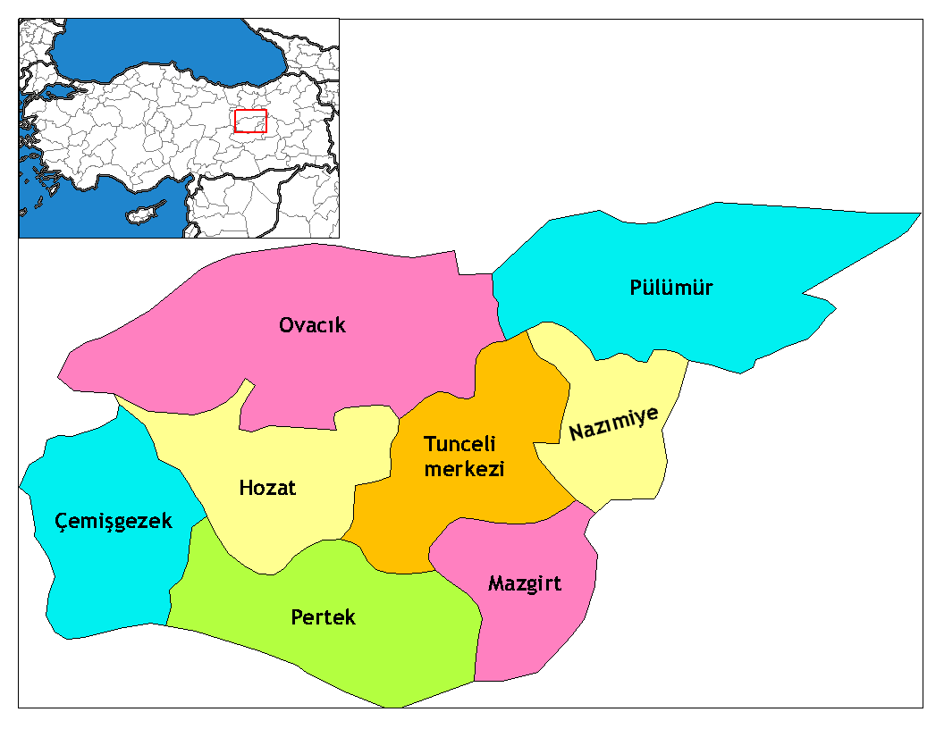
| Deskripsyon | Map of the districts of Tunceli province in Turkey. Created by Rarelibra 17:52, 4 December 2006 (UTC) for public domain use, using MapInfo Professional v8.5 and various mapping resources. Edited by One Homo Sapiens Corrected text where İ,Ş,ı,ğ,or ş occurs in name. Source: [statoids-com]. Increased font size and enhanced color differences among adjacent districts. |
| Petsa | 4 Disyembre 2006 (original upload date) |
| Gigikanan | No machine-readable source provided. Own work assumed (based on copyright claims). |
| Tagsulat | No machine-readable author provided. Rarelibra assumed (based on copyright claims). |
Pagtugot
| I, the copyright holder of this work, release this work into the public domain. This applies worldwide. In some countries this may not be legally possible; if so: I grant anyone the right to use this work for any purpose, without any conditions, unless such conditions are required by law. |
Kaagi sa payl
I-klik ang petsa/oras aron makit-an ang hulagway sa payl niadtong panahona.
| Petsa/Takna | Thumbnail | Mga dimensyon | Tiggamit | Komento | |
|---|---|---|---|---|---|
| kasamtangan | 11:39, 8 Hunyo 2014 | | 1,056 × 816 (30 KB) | Semsûrî | Changed the name |
| 02:50, 29 Disyembre 2008 |  | 1,056 × 816 (30 KB) | One Homo Sapiens | Corrected text where İ,Ş,ı,ğ,or ş occurs in name. Source: [statoids-com]. Increased font size and enhanced color differences among adjacent districts. | |
| 17:52, 4 Disyembre 2006 |  | 1,056 × 816 (30 KB) | Rarelibra | Map of the districts of Tunceli province in Turkey. Created by ~~~~ for public domain use, using MapInfo Professional v8.5 and various mapping resources. |
Mga paggamit sa payl
Ang mosunod nga mga panid misumpay niining payl:
Global nga paggamit sa payl
Kining ubang wiki naggamit ning maong payl:
- Paggamit sa ar.wikipedia.org
- Paggamit sa arz.wikipedia.org
- Paggamit sa ast.wikipedia.org
- Paggamit sa az.wikipedia.org
- Paggamit sa be.wikipedia.org
- Paggamit sa ca.wikipedia.org
- Paggamit sa cs.wikipedia.org
- Paggamit sa de.wikipedia.org
- Tunceli
- Mazgirt
- Nazımiye
- Hozat
- Pertek
- Pülümür
- Ovacık (Tunceli)
- Çemişgezek
- Vorlage:Navigationsleiste Landkreise der Provinz Tunceli
- Akdemir (Pertek)
- Aşağıgülbahçe
- Elmakaşı
- Yenisöğüt
- Yaylagünü
- Yarımkaya
- Yakatarla
- Tatuşağı
- Paşadüzü
- Öveçler
- Mollaaliler
- Kozluca
- Koyungölü
- Konaklar (Ovacık)
- Havuzlu
- Güneykonak
- Gözeler
- Eskigedik
- Çöğürlük
- Çemberlitaş
- Çakmaklı
- Büyükköy (Ovacık)
- Aşağıtorunoba
- Arslandoğmuş
- Akyayık
- Yukarıyakabaşı
- Yeniköy (Pertek)
- Tozkoparan
- Pirinççi
- Pınarlar (Pertek)
- Konurat
- Koçpınar
View more global usage of this file.
Metadata
Text is available under the CC BY-SA 4.0 license; additional terms may apply.
Images, videos and audio are available under their respective licenses.
Cover photo is available under {{::mainImage.info.license.name || 'Unknown'}} license.
Cover photo is available under {{::mainImage.info.license.name || 'Unknown'}} license.
Credit:
(see original file).
