Payl:Côte d'Ivoire map.png
Walay mas taas nga resolusyon.
Côte_d'Ivoire_map.png (326 × 350 pixels, size sa payl: 14 KB, MIME type: image/png)
Mubong sugid:
| Deskripsyon |
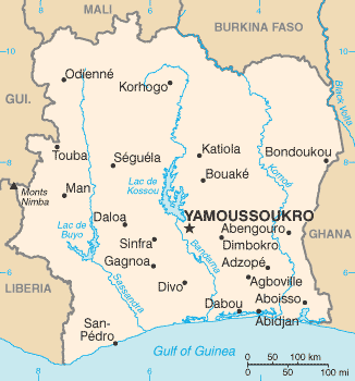
English: Map of Ivory Coast
Español: Mapa de Costa de Marfil mostrando al Bandama en el centro del país |
||
| Petsa | |||
| Gigikanan | CIA World Factbook | ||
| Tagsulat | CIA | ||
| Other versions |
|

Pagtugot
This image is in the public domain because it contains materials that originally came from the United States Central Intelligence Agency's World Factbook.
|
 |
Kaagi sa payl
I-klik ang petsa/oras aron makit-an ang hulagway sa payl niadtong panahona.
| Petsa/Takna | Thumbnail | Mga dimensyon | Tiggamit | Komento | |
|---|---|---|---|---|---|
| kasamtangan | 01:14, 7 Abril 2010 | | 326 × 350 (14 KB) | Ras67 | cropped |
| 22:12, 11 Hunyo 2005 |  | 330 × 352 (23 KB) | Dubaduba~commonswiki | ((PD-USGov-CIA-WF)) |
Mga paggamit sa payl
Ang mosunod nga mga panid misumpay niining payl:
Global nga paggamit sa payl
Kining ubang wiki naggamit ning maong payl:
- Paggamit sa ar.wikipedia.org
- Paggamit sa arz.wikipedia.org
- Paggamit sa ban.wikipedia.org
- Paggamit sa be.wikipedia.org
- Paggamit sa bjn.wikipedia.org
- Paggamit sa bs.wikipedia.org
- Paggamit sa ckb.wikipedia.org
- Paggamit sa da.wikipedia.org
- Paggamit sa de.wikipedia.org
- Paggamit sa dv.wikipedia.org
- Paggamit sa en.wikipedia.org
- Paggamit sa eo.wikipedia.org
- Paggamit sa es.wikipedia.org
- Paggamit sa fa.wikipedia.org
- Paggamit sa fi.wikipedia.org
- Paggamit sa fr.wikipedia.org
- Paggamit sa fy.wikipedia.org
- Paggamit sa ha.wikipedia.org
- Paggamit sa he.wikipedia.org
View more global usage of this file.
Text is available under the CC BY-SA 4.0 license; additional terms may apply.
Images, videos and audio are available under their respective licenses.
Cover photo is available under {{::mainImage.info.license.name || 'Unknown'}} license.
Cover photo is available under {{::mainImage.info.license.name || 'Unknown'}} license.
Credit:
(see original file).
