For faster navigation, this Iframe is preloading the Wikiwand page for Файл:Map of Morris Co, Ks, USA.png.

Файл:Map of Morris Co, Ks, USA.png
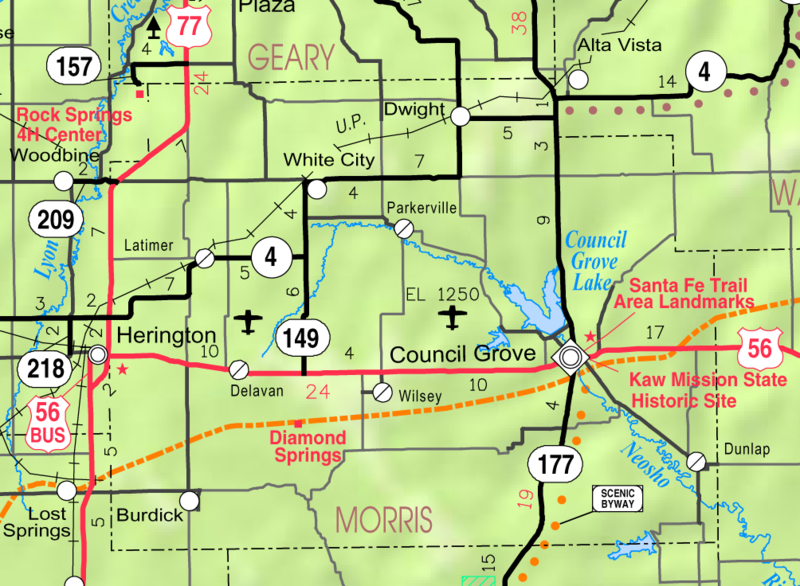
Оригиналан файл(1004 × 736 пиксель, файлан барам: 343 Кб, MIME-тайп: image/png)

ХӀара файл Викиларма чуьра йу и лело йиш йу массо проекташкахь. Цунна хаам гайтина лахахь. Файл Викилармехь

Файлах лаьцна

Цуьнах лаьцна This map of Morris County, Kansas, USA, is copied at a resolution of 300 pixels/inch from the original PDF file.
Терахь
Хьост Kansas 2005–2006 Official Transportation Map [1] (map legend)
Автор Designed and published by the Kansas Department of Transportation.
Бакъонаш
(Йуха хӀара файл лелор)
VRT Wikimedia

ХӀара болх лело бакъо хьаьжна Викимедиа VRT системан архив чу йилина.
Оьцунга хьажа ло карточка сана #2013040310012673, VRTS-аккаунт йолу декъашхой. Бакъо елар бакъдан муьлха цхьан VRTS хьажа тӀекхочучу декъашхочуьнца къамел де.

Дехаран тӀе хьажорг: https://ticket.wikimedia.org/otrs/index.pl?Action=AgentTicketZoom&TicketNumber=2013040310012673
Find other files from the same ticket: SDC query (SPARQL)

Лицензи

Public domain ХӀара произведени цуьна авторо юкъаралин рицӀкъан дӀаелла, Kansas Department of Transportation. бакъо лелаш йу дуьненан массо а меттигашкахь.
Цхьайолу пачхьалкхашкахь юридически магийна дац, иштта делахь:
Kansas Department of Transportation бакъо ло муьлххачунна а хӀара болх лело муьлххачу а Ӏалашонца, цхьа а бехкам боцуш, нагахь санна и бехкамаш низамо тӀедожош дацахь.

This map is published by the Kansas Department of Transportation and is distributed to the public free of charge. KDOT makes no warranties, guarantees, or representations for accuracy of this information and assumes no liability for errors or omissions. Maps produced using tax payer dollars are free for public use.

Куьг

ТӀетоха кху могӀанан тӀе хӀокху файлах лаьцна хаам

ХӀокху файл тӀера элементаш

гойту объект

Файлан истори

Тlетаlаде терахь/хан, муха хилла хьажарна и файл.

Терахь/ХанЖимаФайлан барамДекъашхоБилгалдаккхар
карара2006, 3 апрель, 03:28Жимо верси 2006, 3 апрель, 03:281004 × 736 (343 Кб)MovertonSource: Kansas 2005-2006 Official Transportation Map ((PD-US))

Файл лелор

ХӀара файл лахарчу 1 агӀонгахь лелош йу:

Глобалан файл лелор

ХӀара файл лелош йу лахахь гайтина йолу википедеш чохь:

Хьажа хӀара файл глобалан лелор.

{{bottomLinkPreText}} {{bottomLinkText}}
Файл:Map of Morris Co, Ks, USA.png
Listen to this article

This browser is not supported by Wikiwand :(
Wikiwand requires a browser with modern capabilities in order to provide you with the best reading experience.
Please download and use one of the following browsers:

This article was just edited, click to reload
This article has been deleted on Wikipedia (Why?)

Back to homepage

Please click Add in the dialog above
Please click Allow in the top-left corner,
then click Install Now in the dialog
Please click Open in the download dialog,
then click Install
Please click the "Downloads" icon in the Safari toolbar, open the first download in the list,
then click Install
{{::$root.activation.text}}

Install Wikiwand

Install on Chrome Install on Firefox
Don't forget to rate us

Tell your friends about Wikiwand!

Gmail Facebook Twitter Link

Enjoying Wikiwand?

Tell your friends and spread the love:
Share on Gmail Share on Facebook Share on Twitter Share on Buffer

Our magic isn't perfect

You can help our automatic cover photo selection by reporting an unsuitable photo.

This photo is visually disturbing This photo is not a good choice

Thank you for helping!


Your input will affect cover photo selection, along with input from other users.

X

Get ready for Wikiwand 2.0 🎉! the new version arrives on September 1st! Don't want to wait?