Eifel
| (de) Eifel | |||||
| Tipus | Mitja muntanya, serralada i regió geogràfica | ||||
|---|---|---|---|---|---|
| Localització | |||||
| Entitat territorial administrativa | Rin del Nord - Westfàlia (Alemanya), Renània-Palatinat (Alemanya), Bèlgica i Luxemburg | ||||
| |||||
| Serralada | Massís Esquistós Renà | ||||
| Limita amb | Kölner Bucht und Niederrheinisches Tiefland (en) | ||||
| Dades i xifres | |||||
| Altitud | 747 m | ||||
| Mida | 100 ( | ||||
| Punt més alt | Hohe Acht (en) | ||||
| Material | roca volcànica, llicorella, pedra calcària, quarsita, gres i basalt | ||||
| Superfície | 5.300 km² | ||||


Eifel és una serralada baixa de muntanyes situada a l'oest d'Alemanya i l'est de Bèlgica.
Eifel forma part del Massís de Renània; una part del nord és ocupada pel Parc nacional d'Eifel (des de 2004).
Geografia
[modifica]
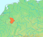
Eifel limta amb el riu Mosel·la al sud i amb el Rin a l'est. Al nord limita amb Jülich-Zülpicher Börde, a l'oest amb les Ardenes de Bèlgica i Luxemburg.
Hi ha diverses cadenes de muntanyes dins Eifel:
- "Nordeifel" incloent Rur Eifel, "Hohes Venn" i "Kalkeifel".
- Ahrgebirge (turons Ahr)[1] (alemany: Ahrgebirge)
- Al sud d'Ahr hi ha el Hohe Eifel amb el Hohe Acht (747 m) que és el cim més alt d'Eifel.
- A l'oest els turons s'anomenen Schneifel (originàriament Schnee-Eifel o "Eifel" niós) i la regió de, Islek (Aquilania).
- La meitat sud d'Eifel és més baixa amb el riu Kyll i els seus turons s'anomenen Kyllwald.
- Al sud Eifel acaba a Voreifel sobre el Mosel·la.
Als períodes geològics Terciari i Quaternari Eifel era una gran zona amb activitat volcànica. Els peculiars llacs maars són d'origen volcànic. Les darreres erupcions volcàniques en el Laacher See van tenir lloc fa uns 10.000 anys però encara hi ha certa activitat volcànica i per això la regió d'Eifel s'eleva cada any 1-2 mm per any.
Castells
[modifica]


Enllaços externs
[modifica]- Historical Background: The Eifel District
- Pictures from Hinterhausen near Gerolstein Arxivat 2016-03-03 a Wayback Machine.
Referències
[modifica]- ↑ Elkins, T.H. (1972). Germany (3rd ed.). London: Chatto & Windus, 1972. ASIN B0011Z9KJA
Text is available under the CC BY-SA 4.0 license; additional terms may apply.
Images, videos and audio are available under their respective licenses.


