Serralada Wasatch
| |||||
| Tipus | serralada | ||||
|---|---|---|---|---|---|
| Localització | |||||
| Entitat territorial administrativa | Comtat de Juab (Utah), Comtat de Utah (Utah), Comtat de Salt Lake (Utah), Comtat de Davis (Utah), Comtat de Summit (Utah), comtat de Morgan (Utah), comtat de Weber (Utah), comtat de Wasatch (Utah), comtat de Sanpete (Utah), Comtat de Box Elder (Utah) i Idaho (EUA) | ||||
| |||||
| Serralada | muntanyes Rocoses | ||||
| Serra | Muntanyes Rocoses | ||||
| Dades i xifres | |||||
| Cims destacats | Mont Nebo (3.636 m) | ||||
| Altitud | 3.636 m | ||||
| Mida | 400 ( | ||||
| Punt més alt | Mont Nebo (Utah) | ||||

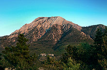
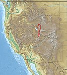
La Serralada Wasatch (en anglès Wasatch Range) és una serralada dels Estats Units que s'estén per uns 250 km des de l'estat de Utah a la frontera amb Idaho i pel centre d'Utah. Generalment es considera que és l'extrem oest de les muntanyes Rocoses, i l'extrem est de la Gran Conca.[1] A l'estat d'Idaho aquest serralada la continua les Muntanyes Bear River.
Wasatch significa en idioma Ute "pas de muntanya."[2]
Aquesta serralada era d'importància vital pels primers colonitzadors, ja que hi trobaven fusta, granit i aigua. Actualment el 85% de la població d'Utah viu a uns 25 km de la serralada.
Cims principals
[modifica]- Mont Nebo. 3.636 m
- Mont Timpanogos. 3.581 m
- American Fork Twin Peaks. 3.502 m
- North Timpanogos. 3.487 m
- Red Top. 3.463 m
- Bomber Peak. 3.459 m
- Broad Fork Twin Peaks. 3.453 m
- Pfeifferhorn. 3.452 m
- White Baldy. 3.451 m
- Sunrise Peak. 3.437 m
- Lone Peak. 3.430 m
Vegeu també
[modifica]Referències
[modifica]- ↑ Hiking the Wasatch, John Veranth, 1988, Salt Lake City.
- ↑ Fuller, Craig. «Wasatch County». Utah History Encyclopedia. [Consulta: 28 novembre 2008].
- Geology of Utah, William Lee Stokes, Utah Museum of Natural History, Salt Lake City, 1986.
- Wasatch Quartzite, John Gottman, Salt Lake City, 1979.
- Wasatch Tours, Alexis Kelner & Dave Hanscom, Wasatch Publishers, Salt Lake City, 1976.
- Flora of the Central Wasatch Front, Utah. L. Arnow, B. Albee, & A Wycoff, University of Utah, Salt Lake City, 1980.
- Gori, P.L. and Hays, W.W. (Eds.) (2000). Assessment of regional earthquake hazards and risk along the Wasatch Front, Utah [U.S. Geological Survey Professional Paper 1500-K-R]. Reston, VA: U.S. Department of the Interior, U.S. Geological Survey.
Enllaços externs
[modifica]- Wasatch Range a peakbagger.com (anglès)
Text is available under the CC BY-SA 4.0 license; additional terms may apply.
Images, videos and audio are available under their respective licenses.


