Riu Limay
| Tipus | Riu | ||||
|---|---|---|---|---|---|
| Inici | |||||
| País de la conca | Argentina | ||||
| Cota inicial | 730 m | ||||
| Entitat territorial administrativa | Argentina | ||||
| Localització | Llac Nahuel Huapi | ||||
| Final | |||||
| Entitat territorial administrativa | Província de Río Negro (Argentina) | ||||
| Localització | Riu Negro | ||||
| Desembocadura | Río Negro | ||||
| |||||
| Afluent | |||||
| Dades i xifres | |||||
| Mida | 500 ( | ||||
| Travessa | Argentina | ||||
| Superfície de conca hidrogràfica | 61.723 km² | ||||
| Mesures i indicadors | |||||
| Cabal | 700 m³/s | ||||
El Limay és un important riu del sud-oest de l'Argentina.
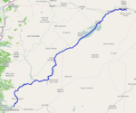
Neix a l'extrem oriental del llac Nahuel Huapi i recorre en forma serpentejant uns 500 km en direcció nord-est, sumant afluents com el Traful, el Pichileufú i el Collón Curá, fins a trobar-se amb el Neuquén, formant a la seva confluència el riu Negro.
El nom Limay és d'origen maputxe, el significat del qual és "riu clar, net".
El riu serveix de límit natural entre les província de Rio Negro i Neuquén. Les seves aigües són clares, i posseeix un important cabal (en mitjana 224 m³/segon). La seva conca té una àrea d'uns 63,700 km² i inclou la majoria dels rius i rierols de la conca de l'atlàntic a la regió, com també una extensa xarxa de llacs interconnectats (Nahuel Huapi, Correntoso, Moreno, Gutiérrez). El riu té una important població de truites, i és popular la pràctica de la pesca, i el descens en caiac i rai.
Donat que el Llac Nahuel Huapi es troba a 730 metres sobre el nivell del mar, s'han instal·lat al curs del Limay successius embassaments hidroelèctrics amb la finalitat d'aprofitar la força hidràulica disponible. Els embassaments són Alicurá, Piedra del Águila, El Chocón, Arroyito i Pichi Picún Leufú.
A les seves proximitats, i alimentada amb aigua del Limay, s'ha construït l'única planta d'aigua pesant de Sud-amèrica (ENSI), a la localitat d'Arroyito, província de Neuquén.
Text is available under the CC BY-SA 4.0 license; additional terms may apply.
Images, videos and audio are available under their respective licenses.


