Província d'Ağrı
| Ağrı il (tr) | |||||
| Localització | |||||
|---|---|---|---|---|---|
| |||||
| Estat | Turquia | ||||
| Capital | Ağrı | ||||
| Conté la subdivisió | |||||
| Població humana | |||||
| Població | 539.657 (2018) | ||||
| Geografia | |||||
| Part de | |||||
| Superfície | 11.376 km² | ||||
| Punt més alt | Ararat (5.137 m) | ||||
| Limita amb | |||||
| Identificador descriptiu | |||||
| Codi postal | 04000–04999 | ||||
| Prefix telefònic | 472 | ||||
| ISO 3166-2 | TR-04 | ||||
| Codi NUTS | TRA21 | ||||
| Lloc web | agri.gov.tr | ||||
La província d'Ağrı (armeni: Արարատի) és una província de la part oriental de Turquia, a la frontera amb Iran. La superfície és d'11.376 km² i la població (2006) de 571.243 habitants. La capital és Ağrı. La població el 1889 era de 47.236 habitants dels quals 8.367 eren armenis i la resta quasi tots kurds; el 1945 la població era de 133.504 habitants i ja no quedaven armenis; els kurds eren 78.987 i la resta turcs.
Fou part del sandjak de Doğubayazıt en temps de l'Imperi Otomà. El seu nom deriva de la muntanya Ağri Dagh (el Mont Ararat). Establert com a il o wilayat sota la república fou dividit en sis kada':
- Karaköse (moderna Agri), capital
- Diyadin
- Dogubayazit (antiga Bayazid), que era l'antiga capital del sandjak
- Eleskert (abans Aleskird o Alasgird)
- Patnos (abans Antab)
- Tutak
Districtes
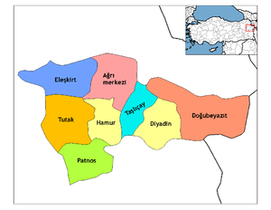
[modifica]Actualment la província està dividida en vuit districtes:
- Ağrı
- Diyadin
- Doğubayazıt
- Eleşkirt
- Hamur
- Patnos
- Taslicay
- Tutak
De la superfície total de la província, el 46% és terreny muntanyós, el 29% són planes, i el 18% és altiplà. Hi ha diverses muntanyes de més de tres mil metres a part del Mont Ararat. incloent l'Aladağlar i el Tendürek. Hi corren alguns afluents del Murat Su. Les temperatures, sobretot a l'hivern, són molt baixes.
Va constituir la República de l'Ararat proclamada pels kurds el 1927, i que no fou controlada per les tropes turques fins al 1930. El 2007 s'hi va produir un terratrèmol.
| NUTS-1 Regions | |
|---|---|
| NUTS-2 Subregions | |
| NUTS-3 Províncies (il) | TR100 • TR211 • TR212 • TR213 • TR221 • TR222 • TR310 • TR321 • TR322 • TR323 • TR331 • TR332 • TR333 • TR334 • TR411 • TR412 • TR413 • TR421 • TR422 • TR423 • TR424 • TR425 • TR510 • TR521 • TR522 • TR611 • TR612 • TR613 • TR621 • TR622 • TR631 • TR632 • TR633 • TR711 • TR712 • TR713 • TR714 • TR715 • TR721 • TR722 • TR723 • TR811 • TR812 • TR813 • TR821 • TR822 • TR823 • TR831 • TR832 • TR833 • TR834 • TR901 • TR902 • TR903 • TR904 • TR905 • TR906 • TRA11 • TRA12 • TRA13 • TRA21 • TRA22 • TRA23 • TRA24 • TRB11 • TRB12 • TRB13 • TRB14 • TRB21 • TRB22 • TRB23 • TRB24 • TRC11 • TRC12 • TRC13 • TRC21 • TRC22 • TRC31 • TRC32 • TRC33 • TRC34 |
| LAU-1 | Districtes (ilçe) |
| LAU-2 | |
| Àrees metropolitanes | |
| Ciutats més poblades | |
| Regions geogràfiques | |
Text is available under the CC BY-SA 4.0 license; additional terms may apply.
Images, videos and audio are available under their respective licenses.


