Oest del Canadà
| Tipus | Regió geogràfica | ||||
|---|---|---|---|---|---|
| Localització | |||||
| Entitat territorial administrativa | Alberta (Canadà), Colúmbia Britànica (Canadà), Saskatchewan (Canadà) i Manitoba (Canadà) | ||||
| |||||
| Dades i xifres | |||||
| Superfície | 2.703.159 km² | ||||

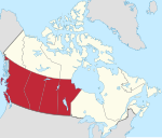
L'Oest del Canadà (en anglès:Western Canada o Western provinces, en francès: Ouest canadien) són les regions del Canadà que inclouen les 4 províncies del Canadà situades a l'oest de la província d'Ontario.
Províncies
[modifica]D'oest a est, les quatre províncies que componen aquesta regió són British Columbia, Alberta, Saskatchewan i Manitoba.
Les tres darreres (Alberta, Saskatchewan i Manitoba) es coneixen col·lectivament en anglès com les Prairie Provinces, o simplement the Prairies. La Colúmbia Britànica (British Columbia) també es coneix en anglès com la Pacific Province, i en un sentit més geogràfic també com la Pacific Slope i de vegades de forma intercanviable com "the West Coast". Alberta i British Columbia de vegades s'anomenen les "mountain provinces".
En alguns contextos, el terme Western Canada també pot incloure els territoris de Yukon, Northwest Territories i Nunavut, malgrat que actualment aquests s'inclouen en la regió diferent anomenada Nord del Canadà (Northern Canada).
La regió Oest del Canadà ocupa una superfície de 2.908.433 km², o aproximadament un 29% de la superfície del Canadà. Segons el cens de 2011 la regió té uns 10,3 milions d'habitants (suma de la població de la Colúmbia Britànica, Alberta, Saskatchewan i Manitoba).[1]
La font d'aquesta divisió en regions és per ocupar els escons en el Senat del Canadà tal com estableix la Constitució del Canadà.
Referències
[modifica]- ↑ «Population and dwelling counts, for Canada, provinces and territories, 2011 and 2006 censuses». Statistics Canada, 08-02-2012. [Consulta: 11 febrer 2012].
Bibliografia
[modifica]- Felske, Lorry W. Challenging frontiers: the Canadian west. University of Calgary Press, 2004. ISBN 1-55238-140-4.
- Gardner, Matthew. Western Canada. Footprint, 2008. ISBN 488403035.
Enllaços externs
[modifica]Text is available under the CC BY-SA 4.0 license; additional terms may apply.
Images, videos and audio are available under their respective licenses.


