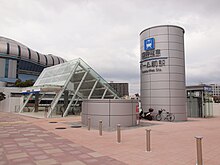
Nishi (Osaka)
| 西区 (ja) | |||||
| Localització | |||||
|---|---|---|---|---|---|
| |||||
| Estat | Japó | ||||
| Prefectura | prefectura d'Ōsaka | ||||
| Ciutat designada | Osaka | ||||
| Població humana | |||||
| Població | 105.006 (2021) | ||||
| Geografia | |||||
| Superfície | 5,2 km² | ||||
| Banyat per | Canal d'Iwasaki, Riu Kizu i Riu Sangenya | ||||
| Creació | 1879 | ||||
| Identificador descriptiu | |||||
| Fus horari | |||||
| Lloc web | city.osaka.lg.jp… | ||||
Nishi (西区, Nishi-ku) és un del 24 districtes urbans de la ciutat d'Osaka, capital de la prefectura homònima, a la regió de Kansai, Japó.[1] Nishi és un districte fonamentalment econòmic i central més que residencial. El nom del districte es pot traduir al català com a "oest" u "occident", fent referència a la posició geogràfica del districte a la ciutat.
Geografia
[modifica]El districte urbà de Nishi es troba localitzat al centre geogràfic de la ciutat d'Osaka, capital de la prefectura homònima. El territori del districte limita amb els de Konohana, Fukushima i Kita al nord, amb Naniwa i Taishō al sud, amb Minato a l'oest i Chūō a l'est.
Barris
[modifica]Els chōchō o barris del districte són els següents:[2]
- Ajigawa (安治川)
- Awaza (阿波座)
- Itachibori (立売堀)
- Utsubo-Honmachi (靱本町)
- Edobori (江戸堀)
- Enokojima (江之子島)
- Kawaguchi (川口)
- Kita-Horie (北堀江)
- Kyōmachibori (京町堀)
- Kujō (九条)
- Kujō-Minami (九条南)
- Sakaigawa (境川)
- Shin-machi (新町)
- Chiyozaki (千代崎)
- Tosabori (土佐堀)
- Nishi-Honmachi (西本町)
- Honden (本田)
- Minami-Horie (南堀江)
Història
[modifica]El districte de Nishi va ser creat l'any 1879, sent fundat alhora que la ciutat d'Osaka i sent el districte urbà més antic d'aquesta junt amb Kita.[3] Durant la Segona Guerra Mundial, aproximadament el 80 percent del territori del districte va ser destruït, no tornant a recuperar-se fins a mitjans de la dècada de 1960.[4]
Demografia
[modifica]| 1920 | 1930 | 1940 | 1950 | 1960 | 1970 | 1980 |
|---|---|---|---|---|---|---|
| ND | ND | ND | ND | ND | 56.980 | 53.695 |
| 1990 | 2000 | 2010 | 2020 | 2030 | 2040 | 2050 |
| 59.288 | 63.402 | 83.058 | 104.811 | - | - | - |
Transport
[modifica]
Ferrocarril
[modifica]- Metro d'Osaka
- Higobashi - Honmachi - Yotsubashi - Kujō - Awaza - Nishi-Nagahori - Dome-mae Chiyozaki - Nishi-Ōhashi
- Ferrocarril Elèctric Hanshin
- Kujô - Dome-mae
Carretera
[modifica]- Autopista Hanshin
- Carreteres prefecturals
Referències
[modifica]- ↑ https://map.yahoo.co.jp/address?ac=27106
- ↑ https://minchizu.jp/osaka/o-nishi.html
- ↑ https://www.oml.city.osaka.lg.jp/index.php?page_id=1149
- ↑ Nishi Ward Official Website Arxivat 2007-08-27 a Wayback Machine. - "Ward Overview", retrieved 10 September 2007 (dead link now )
- ↑ Statistics Bureau of Japan
| Ciutats | |||||||||||
|---|---|---|---|---|---|---|---|---|---|---|---|
| Ku |
| ||||||||||
| Districtes |
| ||||||||||
Text is available under the CC BY-SA 4.0 license; additional terms may apply.
Images, videos and audio are available under their respective licenses.


