For faster navigation, this Iframe is preloading the Wikiwand page for Tundja.

Tundja

Plantilla:Infotaula geografia políticaTundja

Localització
lang=ca Modifica el valor a Wikidata Map
 42° 30′ N, 26° 30′ E / 42.5°N,26.5°E / 42.5; 26.5
PaísBulgària
Provínciaprovíncia de Iambol Modifica el valor a Wikidata
CapitalIambol Modifica el valor a Wikidata
Població humana
Població27.008 (2008) Modifica el valor a Wikidata (22,16 hab./km²)
Geografia
Superfície1.218,88 km² Modifica el valor a Wikidata
Altitud162 m Modifica el valor a Wikidata
Limita amb
Organització política
• Cap de governStancho Stavrev (en) Tradueix (2023–) Modifica el valor a Wikidata
Identificador descriptiu
Fus horari

Lloc webtundzha.net Modifica el valor a Wikidata

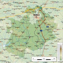
El municipi de Tundja (búlgar: Община Тунджа) és un municipi búlgar pertanyent a la província de Iàmbol, amb capital a la capital provincial Iàmbol, tot i que aquesta no es troba en el seu municipi. El municipi compren els voltants de la ciutat de Iàmbol. Per al seu municipi hi flueix el riu Tundzha, del que en pren el nom.[1]

L'any 2011 tenia 24.155 habitants,[2] el 89,36 búlgars i el 8,73% gitanos i l'0,46% turcs.[3]

Localitats

[modifica]

Tundzha comprèn els següents pobles:[4]

  • Asenovo
  • Bezmer
  • Bolyarsko
  • Botevo
  • Boyadzhik
  • Chargan
  • Chelnik
  • Drazhevo
  • Drama
  • Dryanovo
  • Hadzhidimitrovo
  • Hanovo
  • General Inzovo
  • General Toshevo
  • Golyam Manastir
  • Galabintsi
  • Kabile
  • Kalchevo
  • Karavelovo
  • Kozarevo
  • Konevets
  • Krumovo
  • Kukorevo
  • Malomir
  • Meden Kladenets
  • Mezhda
  • Miladínovtsi
  • Moguila
  • Okop
  • Ovchi Kladenets
  • Pobeda
  • Robovo
  • Roza
  • Sávino
  • Simeonovo
  • Skalitsa
  • Slamino
  • Stara Reka
  • Tarnava
  • Tenevo
  • Veselinovo
  • Vidintsi
  • Zavoy
  • Zlatari

Referències

[modifica]
  1. «Mapa de Tundzha». Google Maps.
  2. «Етнически състав на населените места в България според преброяването на населението през 2011 г.» (en anglès). pop-stat.mashke.org, 2015. [Consulta: 28 febrer 2018].
  3. «НАСЕЛЕНИЕ ПО ОБЛАСТИ, ОБЩИНИ, НАСЕЛЕНИ МЕСТА И САМООПРЕДЕЛЕНИЕ ПО ЕТНИЧЕСКА ПРИНАДЛЕЖНОСТ КЪМ 1.02.2011 ГОДИНА» (en búlgar). Национален статистически институт (Institut Nacional d'Estadística de Bulgària). [Consulta: 28 febrer 2018].
  4. «Преброяване на населението» (en búlgar). National Statistical Institute - Republic Of Bulgaria, 01-02-2011. Arxivat de l'original el 13 de juny 2018. [Consulta: 2 d’abril 2021].
{{bottomLinkPreText}} {{bottomLinkText}}
Tundja
Listen to this article

This browser is not supported by Wikiwand :(
Wikiwand requires a browser with modern capabilities in order to provide you with the best reading experience.
Please download and use one of the following browsers:

This article was just edited, click to reload
This article has been deleted on Wikipedia (Why?)

Back to homepage

Please click Add in the dialog above
Please click Allow in the top-left corner,
then click Install Now in the dialog
Please click Open in the download dialog,
then click Install
Please click the "Downloads" icon in the Safari toolbar, open the first download in the list,
then click Install
{{::$root.activation.text}}

Install Wikiwand

Install on Chrome Install on Firefox
Don't forget to rate us

Tell your friends about Wikiwand!

Gmail Facebook Twitter Link

Enjoying Wikiwand?

Tell your friends and spread the love:
Share on Gmail Share on Facebook Share on Twitter Share on Buffer

Our magic isn't perfect

You can help our automatic cover photo selection by reporting an unsuitable photo.

This photo is visually disturbing This photo is not a good choice

Thank you for helping!


Your input will affect cover photo selection, along with input from other users.

X

Get ready for Wikiwand 2.0 🎉! the new version arrives on September 1st! Don't want to wait?