For faster navigation, this Iframe is preloading the Wikiwand page for Fitxer:Vinland Map HiRes.jpg.

Fitxer:Vinland Map HiRes.jpg
Fitxer original(3.038 × 2.103 píxels, mida del fitxer: 2,48 Mo, tipus MIME: image/jpeg)

Descripció a Commons
Imatge of the year
Imatge of the year
Featured imatge

Wikimedia CommonsViquipèdia

Aquesta imatge ha estat candidata a Imatge de l'any 2007.
Aquest és un arxiu d'imatge destacat a Wikimedia Commons (Imatges destacades) i és considerat un dels més acurats arxius d'imatge.

 Aquest és un arxiu d'imatge destacat a La Viquipèdia en anglès (Featured pictures) i és considerat un dels més acurats arxius d'imatge.
 Aquest és un arxiu d'imatge destacat a La Viquipèdia en turc (Seçkin resimler) i és considerat un dels més acurats arxius d'imatge.

Si teniu una imatge de qualitat similar que es pot publicar sota una llicència de copyright adient, animeu-vos a carregar-la, identificar-la i nominar-la.

Resum

Descripció Dimensions: 27.8 by 41.0 centimeters (10.9 by 16.1 inches)
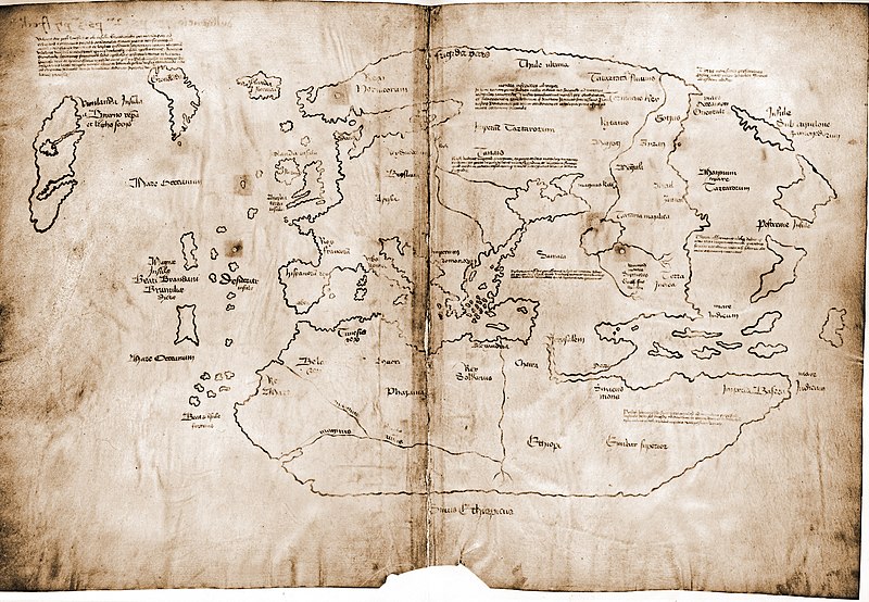
English: The Vinland map / chart is purportedly a 15th century Mappa Mundi, redrawn from a 13th century original. Drawn with black ink on animal skin, if authentic the map is the first known depiction of the North American coastline, created before Columbus' 1492 voyage. The upper left caption reads: “By God's will, after a long voyage from the island of Greenland to the south toward the most distant remaining parts of the western ocean sea, sailing southward amidst the ice, the companions Bjarni and Leif riksson discovered a new land, extremely fertile and even having vines, ... which island they named Vinland.” Most scholars and scientists who have studied the map have concluded that it is a fake, probably drawn on old parchment in the 20th century.
Deutsch: Die Vinland Mappe / Karte ist angeblich eine Weltkarte des 15. Jahrhunderts, neu gezeichnet von einem Original aus dem 13. Jahrhundert . Gezeichnet mit schwarzer Tinte auf Tierhaut, wenn sie echt wäre, wäre die Karte die erste bekannte Darstellung der nordamerikanischen Küste, die vor Kolumbus' Reise 1492. Im linken oberen Teil Inschrift: "Mit Gottes Willen, nach einer langen Reise von der Insel Grönland nach Süden durch das Eis segelnd zu den am weitesten entfernten übrigen Teilen des westlichen Ozeans, entdeckten die Gefährten Bjarni und Leif Erikssohn ein neues Land, äußerst fruchtbar und sogar mit Reben, eine Insel, die sie Vinland nannten" Die meisten Gelehrten und Wissenschaftler, die die Karte untersucht haben, kommen zu dem Schluss, dass die Karte eine Fälschung ist, die wahrscheinlich im 20. Jahrhundert auf alten Pergament gezeichnet wurde.
Français : La carte du Vinland est une carte datant peut-être du XVe siècle, et reprenant un original du XIIIe siècle. Tracée à l'encre noire sur du parchemin, cette carte est la première carte connue montrant la côte de L'Amérique du Nord, et est plus ancienne que le voyage de Christophe Colomb (1492). La légende en haut à gauche se lit “Par la volonté de Dieu et après un long voyage depuis l'île du Groenland vers les parts les plus lointaines de la mer océane de l'ouest, naviguant au sud au milieu des glaces, les compagnons Bjarni et Leif Eiriksson découvrirent une nouvelle terre, très fertile et portant de la vigne [...] ils la nommèrent Vinland.” La plupart des études au sujet de cette carte suggèrent qu'elle est truquée, dessinée au 20me siècle sur deux feuilles de parchemin anciennes.
Polski: Uznawana jako XV-wieczna mapa świata, przerysowana z XIII-wiecznego oryginału, gdyby była prawdziwa zawierała by pierwszy znany opis wybrzeży Ameryki Północnej zwanej wówczas Vinland. Obecnie jednak na podstawie analizy składu atramentu jest uznawana za fałszerstwo powstałe po 1923 roku.
Українська: Мапа Вінланду з атласу «Mappa mundi» XV століття, зроблена з оригіналу XIII століття. Зображення нанесені чорною фарбою на шкірі тварини. Автентична карта є першим відомим зображенням північноамериканського узбережжя, що було створене до подорожі Христофора Колумба 1492 року. У верхньому лівому кутку напис: «За Божою волею, після довгого плавання від острова Гренландія на південь до найдальших частин Західного океану моря, плавання на південь серед криги, товариші Б'ярні і Лейф Ерікссон віднайшли нову землю, дуже родючу й багату на виноград... землі названі Вінландом.» Більшість дослідників і вчених, які вивчали карту, дійшли висновку, що це фальшивка, ймовірно, зроблена на старому пергаменті у XX столітті.
العربية: الأبعاد: 27.8 × 41.0 سم (10.9 × 16.1 بوصة) {يُقال إن خريطة/مخطط فينلاند هي خريطة موندي من القرن الخامس عشر، أعيد رسمها من نسخة أصلية من القرن الثالث عشر. تم رسمها بالحبر الأسود على جلد حيوان، وإذا كانت أصلية، فهي أول تصوير معروف لساحل أمريكا الشمالية، تم رسمها قبل رحلة كولومبوس عام 1492. يقرأ التعليق العلوي الأيسر: "بمشيئة الله، بعد رحلة طويلة من جزيرة جرينلاند إلى الجنوب نحو أبعد الأجزاء المتبقية من بحر المحيط الغربي، والإبحار جنوبًا وسط الجليد، اكتشف الرفيقان بيارني وليف ريكسون أرضًا جديدة، خصبة للغاية وحتى بها كروم، ... الجزيرة التي أطلقوا عليها اسم فينلاند". استنتج معظم الباحثين والعلماء الذين درسوا الخريطة أنها مزيفة، وربما رسمت على رق قديم في القرن العشرين.
Data
Font Yale University, from this website
Autor Yale University Press

Llicència

If the map is real, then it is public domain by virtue of its age. In the far more likely possibility of it being fake, it is public domain because it was published without copyright notice before 1977 (even ignoring the question of if the true creator of the map forfeited copyright protection immediately by not openly claiming the work).

Això és una mera fotografia d'una obra d'art bidimensional en domini públic. L'obra d'art original és en domini públic pel següent motiu:
Public domain

Aquest material està en domini públic als Estats Units i als altres països on el dret d'autor s'estén per 100 anys (o menys) després de la mort de l'autor.


Cal incloure una etiqueta de domini públic als Estats Units per indicar perquè aquesta obra és en domini públic als Estats Units.
La posició oficial de la Fundació Wikimedia és que «les reproduccions fidels d'obres d'art bidimensionals de domini públic són en domini públic».
Per tant, aquesta reproducció fotogràfica també es considera en domini públic als Estats Units. En altres jurisdiccions la reutilització d'aquest contingut pot estar restringida; vegeu Reuse of PD-Art photographs per a més informació.
This work is in the public domain in the United States because it was published in the United States between 1929 and 1977, inclusive, without a copyright notice. For further explanation, see Commons:Hirtle chart as well as a detailed definition of "publication" for public art.

العربية  беларуская (тарашкевіца)  čeština  Deutsch  Ελληνικά  English  español  français  Bahasa Indonesia  italiano  日本語  한국어  македонски  Nederlands  português  русский  sicilianu  slovenščina  ไทย  Tiếng Việt  中文(简体)  中文(繁體)  +/−

Flag of the United States
Anotacions
InfoField
Aquesta imatge té anotacions: Vegeu-les a Commons

Llegendes

Afegeix una explicació d'una línia del que representa aquest fitxer

Elements representats en aquest fitxer

representa l'entitat

Historial del fitxer

Cliqueu una data/hora per veure el fitxer tal com era aleshores.

Data/horaMiniaturaDimensionsUsuari/aComentari
actual23:15, 7 set 2007Miniatura per a la versió del 23:15, 7 set 20073.038 × 2.103 (2,48 Mo)Jeff Dahl((Information |Description=The Vinland map is purportedly a 15th century Mappa Mundi, redrawn from a 13th century original. |Source=Yale University |Date=9-7-07 |Author= |Permission= |other_versions= ))

Ús del fitxer

Ús global del fitxer

Utilització d'aquest fitxer en altres wikis:

Vegeu més usos globals d'aquest fitxer.

Metadades

{{bottomLinkPreText}} {{bottomLinkText}}
Fitxer:Vinland Map HiRes.jpg
Listen to this article

This browser is not supported by Wikiwand :(
Wikiwand requires a browser with modern capabilities in order to provide you with the best reading experience.
Please download and use one of the following browsers:

This article was just edited, click to reload
This article has been deleted on Wikipedia (Why?)

Back to homepage

Please click Add in the dialog above
Please click Allow in the top-left corner,
then click Install Now in the dialog
Please click Open in the download dialog,
then click Install
Please click the "Downloads" icon in the Safari toolbar, open the first download in the list,
then click Install
{{::$root.activation.text}}

Install Wikiwand

Install on Chrome Install on Firefox
Don't forget to rate us

Tell your friends about Wikiwand!

Gmail Facebook Twitter Link

Enjoying Wikiwand?

Tell your friends and spread the love:
Share on Gmail Share on Facebook Share on Twitter Share on Buffer

Our magic isn't perfect

You can help our automatic cover photo selection by reporting an unsuitable photo.

This photo is visually disturbing This photo is not a good choice

Thank you for helping!


Your input will affect cover photo selection, along with input from other users.

X

Get ready for Wikiwand 2.0 🎉! the new version arrives on September 1st! Don't want to wait?