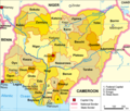
Fitxer:Nigeria political.png
Nigeria_political.png (567 × 482 píxels, mida del fitxer: 183 Ko, tipus MIME: image/png)
Historial del fitxer
Cliqueu una data/hora per veure el fitxer tal com era aleshores.
| Data/hora | Miniatura | Dimensions | Usuari/a | Comentari | |
|---|---|---|---|---|---|
| actual | 01:23, 25 set 2015 |  | 567 × 482 (183 Ko) | Jamie Tubers | Changed "Federal Capital" to "Federal Capital Territory" |
| 04:52, 28 març 2009 |  | 567 × 482 (145 Ko) | Xandar | ((Information |Description=Political map of the 36 en:States of Nigeria |Source= |Date=27.3.2009 |Author=xandar adapted from Domenico-de-ga |Permission=Released under the GNU Free Documentation License. |other_versions=Datei:Nigeria-karte-politisch.pn |
Ús del fitxer
Les 40 pàgines següents utilitzen aquest fitxer:
- Abia
- Abuja
- Akwa Ibom
- Anambra
- Bayelsa
- Cross River
- Ebonyi
- Estat Edo
- Estat Ekiti
- Estat d'Adamawa
- Estat d'Enugu
- Estat d'Ondo
- Estat d'Osun
- Estat d'Oyo
- Estat de Bauchi
- Estat de Benue
- Estat de Borno
- Estat de Gombe
- Estat de Kaduna
- Estat de Kano
- Estat de Katsina
- Estat de Kebbi
- Estat de Kogi
- Estat de Lagos
- Estat de Nasarawa
- Estat de Plateau
- Estat de Sokoto
- Estat de Taraba
- Estat de Zamfara
- Estat del Delta
- Estat del Níger
- Estats de Nigèria
- Imo
- Jigawa
- Kwara
- Ogun
- Rivers
- Territori de la Capital Federal (Nigèria)
- Yobe
- Plantilla:Estats de Nigèria
Ús global del fitxer
Utilització d'aquest fitxer en altres wikis:
- Utilització a af.wikipedia.org
- Utilització a am.wikipedia.org
- Utilització a an.wikipedia.org
- Utilització a ar.wikipedia.org
- Utilització a bjn.wikipedia.org
- Utilització a btm.wikipedia.org
- Utilització a cs.wikipedia.org
- Utilització a da.wikipedia.org
- Utilització a en.wikipedia.org
- States of Nigeria
- Template:Nigeria states map
- Subdivisions of Nigeria
- Wikipedia:Graphics Lab/Map workshop/Archive/Feb 2010
- Nigerian state governors 2011–2015 term
- Template:States of Nigeria Image Map
- 2012 Nigeria floods
- Miss World riots
- Lists of Nigerian state governors
- Portal:Nigeria/Selected picture
- Portal:Nigeria/Selected picture/4
- User:Eoc46/sandbox
- Utilització a en.wikinews.org
- Utilització a eu.wikipedia.org
- Utilització a fa.wikipedia.org
- Utilització a ga.wikipedia.org
- Utilització a ha.wikipedia.org
- Utilització a hi.wikipedia.org
- Utilització a hu.wiktionary.org
- Utilització a hy.wikipedia.org
- Utilització a id.wikipedia.org
- Utilització a incubator.wikimedia.org
- Utilització a is.wikipedia.org
- Utilització a ka.wikipedia.org
- Utilització a ku.wikipedia.org
- Utilització a lez.wikipedia.org
- Utilització a mk.wikipedia.org
- Utilització a mrj.wikipedia.org
Vegeu més usos globals d'aquest fitxer.
Metadades
Text is available under the CC BY-SA 4.0 license; additional terms may apply.
Images, videos and audio are available under their respective licenses.


