For faster navigation, this Iframe is preloading the Wikiwand page for Fitxer:Kandahar districts.png.

Fitxer:Kandahar districts.png
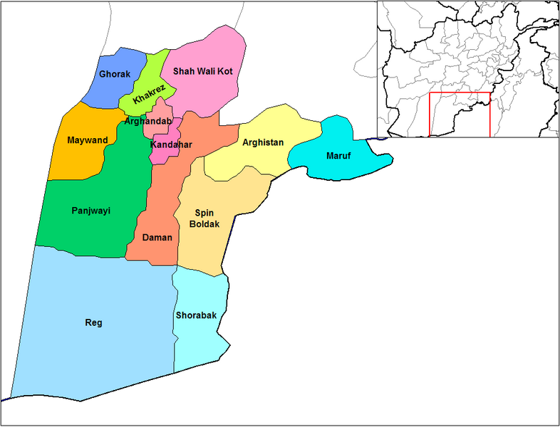
Fitxer original(1.000 × 763 píxels, mida del fitxer: 30 Ko, tipus MIME: image/png)

Descripció a Commons
Aquesta imatge (de tipus locator map) s'hauria de tornar a crear utilitzant gràfics vectorials com ara un fitxer SVG. Això té diversos avantatges; en trobareu més informació a Commons:Media for cleanup. Si ja disposeu d'una versió d'aquesta imatge en format SVG, us preguem que la pengeu; després, reemplaceu aquesta plantilla amb la plantilla ((Vector version available|nom nou de la imatge.svg)) en aquesta imatge.

Resum

English: Map of the districts of Kandahar province of Afghanistan. Created by Rarelibra 19:26, 29 March 2007 (UTC) for public domain use, using MapInfo Professional v8.5 and various mapping resources.

Llicència

Public domain Jo, el titular del copyright d'aquesta obra, l'allibero al domini públic. Això s'aplica a tot el món.
En alguns països això pot no ser legalment possible, en tal cas:
Jo faig concessió a tothom del dret d'usar aquesta obra per a qualsevol propòsit, sense cap condició llevat d'aquelles requerides per la llei.

Llegendes

Afegeix una explicació d'una línia del que representa aquest fitxer

Elements representats en aquest fitxer

representa l'entitat

Historial del fitxer

Cliqueu una data/hora per veure el fitxer tal com era aleshores.

Data/horaMiniaturaDimensionsUsuari/aComentari
actual16:47, 15 feb 2024Miniatura per a la versió del 16:47, 15 feb 20241.000 × 763 (30 Ko)User-duckCropped 5 % horizontally, 6 % vertically using CropTool with lossless mode.
21:26, 29 març 2007Miniatura per a la versió del 21:26, 29 març 20071.056 × 816 (30 Ko)RarelibraMap of the districts of Kandahar province of Afghanistan. Created by ~~~~ for public domain use, using MapInfo Professional v8.5 and various mapping resources.

Ús del fitxer

Les 2 pàgines següents utilitzen aquest fitxer:

Ús global del fitxer

Utilització d'aquest fitxer en altres wikis:

Vegeu més usos globals d'aquest fitxer.

Metadades

{{bottomLinkPreText}} {{bottomLinkText}}
Fitxer:Kandahar districts.png
Listen to this article

This browser is not supported by Wikiwand :(
Wikiwand requires a browser with modern capabilities in order to provide you with the best reading experience.
Please download and use one of the following browsers:

This article was just edited, click to reload
This article has been deleted on Wikipedia (Why?)

Back to homepage

Please click Add in the dialog above
Please click Allow in the top-left corner,
then click Install Now in the dialog
Please click Open in the download dialog,
then click Install
Please click the "Downloads" icon in the Safari toolbar, open the first download in the list,
then click Install
{{::$root.activation.text}}

Install Wikiwand

Install on Chrome Install on Firefox
Don't forget to rate us

Tell your friends about Wikiwand!

Gmail Facebook Twitter Link

Enjoying Wikiwand?

Tell your friends and spread the love:
Share on Gmail Share on Facebook Share on Twitter Share on Buffer

Our magic isn't perfect

You can help our automatic cover photo selection by reporting an unsuitable photo.

This photo is visually disturbing This photo is not a good choice

Thank you for helping!


Your input will affect cover photo selection, along with input from other users.

X

Get ready for Wikiwand 2.0 🎉! the new version arrives on September 1st! Don't want to wait?