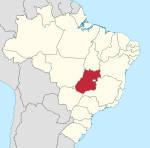
Estat de Goiás
| Himne | Anthem of Goiás (en) | ||||
|---|---|---|---|---|---|
| Epònim | Goyazes | ||||
| Localització | |||||
| |||||
| Estat | Brasil | ||||
| Capital | Goiânia | ||||
| Conté la subdivisió | |||||
| Població humana | |||||
| Població | 6.730.848 (2016) | ||||
| Llengua utilitzada | avà-canoeiro carajà | ||||
| Geografia | |||||
| Entitat estadística | Regió Centre-Oest del Brasil | ||||
| Superfície | 340.086 km² | ||||
| Altitud | 607 m | ||||
| Limita amb | |||||
| Dades històriques | |||||
| Anterior | |||||
| Creació | 1889 | ||||
| Organització política | |||||
| Òrgan executiu | cabinet of the governor of the state of Goias (en) | ||||
| • Governor of Goiás (en) | Ronaldo Caiado (2019–) | ||||
| Òrgan legislatiu | Legislative Assembly of Goiás (en) | ||||
| Identificador descriptiu | |||||
| Fus horari | |||||
| ISO 3166-2 | BR-GO | ||||
| Lloc web | goias.gov.br | ||||
Goiás és un estat del Brasil situat a l'est de la regió Centre-Oest. Limita al nord amb Tocantins, a l'est amb Bahia, a l'est i sud-est amb Minas Gerais al sud-oest amb Mato Grosso do Sul i a l'oest amb Mato Grosso. A l'est de l'estat hi ha enclavat el Districte Federal. Té una superfície de 341.289,5 km².[1]
La capital és Goiânia. Altres ciutats importants són: Trindade, Anápolis, Rio Verde, Catalão i Luziânia. Goiás integra l'Altiplà Central del Brasil, sent constituït per terres planes l'altura de les quals varia entre 200 i 800 metres. Paranaíba, Aporé, Araguaia, São Marcs, Corumbá, Claro, Paranã i Maranhão són els rius principals.[2]
Municipis
[modifica]Vegeu també
[modifica]Referències
[modifica]- ↑ «Información del Estado de Goiás, Brasil». Embajada de Brasil. [Consulta: 18 octubre 2021].
- ↑ «Goiás: capital, mapa, bandeira, população, história» (en portuguès brasiler). Brasil Escola - UOL. [Consulta: 18 octubre 2021].
| Nord | ||
|---|---|---|
| Nord-est | ||
| Centre-Oest | ||
| Sud-est | ||
| Sud | ||
Text is available under the CC BY-SA 4.0 license; additional terms may apply.
Images, videos and audio are available under their respective licenses.


