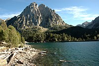
Estany Clot
| Tipus | Llac glacial | |||
|---|---|---|---|---|
| Localitzat a l'entitat geogràfica | capçalera de Caldes | |||
| Localitzat en l'àrea protegida | Parc Nacional d'Aigüestortes i Estany de Sant Maurici | |||
| Localització | ||||
| Entitat territorial administrativa | la Vall de Boí (Alta Ribagorça) | |||
| ||||
| Serralada | Pirineus | |||
| Conca hidrogràfica | conca de l'Ebre | |||
| Dades i xifres | ||||
| Altitud | 2.280 m | |||
| Mida | 0,78 ( | |||
| Material | granit | |||
| Superfície | 1,51 ha | |||
L'Estany Clot és un llac que es troba en el terme municipal de la Vall de Boí, a la comarca de l'Alta Ribagorça, i dins del Parc Nacional d'Aigüestortes i Estany de Sant Maurici.
El llac, d'origen glacial, està situat a 2.280[1] metres d'altitud, a la Capçalera de Caldes. Situat al peu de les Agulles de Travessani i Pic de Travessani, que es localitzen al seu est, drena cap a l'Estany de Travessani.
L'estany és molt pròxim al Refugi Joan Ventosa i Calvell. Dos dels camins que surten del refugi passen pel costat:
- El que, coincidint amb l'etapa de la travessa Carros de Foc, vorejant per la riba oriental de l'Estany de Travessani i travessant el Coret de Oelhacrestada, porta al Refugi de la Restanca.
- Les diverses rutes que porten al Port de Caldes.
Referències
[modifica]- ↑ Altituds, mides i càlcul de superfícies basats en dades del mapa de l'Institut Cartogràfic i Geològic de Catalunya
- ↑ Editorial Alpina. Vall de Boí [mapa], Primera edició, 1:25.000, L. Cartografia de Servicio Geográfico del Ejército. (febrer 2001)
Bibliografia
[modifica]- Editorial Alpina. Vall de Boí [mapa], Primera edició, 1:25.000, L. Cartografia de Servicio Geográfico del Ejército. (febrer 2001)
- Editorial Alpina. Carros de Foc [mapa], 1:25.000, L. Cartografia de Servicio Geográfico del Ejército. (2007)
- Institut Cartogràfic de Catalunya. Parc Nacional d'Aigües Tortes i Estany de Sant Maurici [mapa], Segona edició, 1:25.000. (abril 1998)
| Estanys de la vall d'Espot | ||
|---|---|---|
| Estanys de la Capçalera de Caldes | ||
| Estanys de la Coma del Pessó | ||
| Estanys de la Ribera de Caldes | ||
| Estanys de la vall de Sant Nicolau |
| |
| Altres estanys | ||
Text is available under the CC BY-SA 4.0 license; additional terms may apply.
Images, videos and audio are available under their respective licenses.


