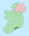
Comtat de Waterford
| Contae Phort Láirge (ga) | |||||
| Localització | |||||
|---|---|---|---|---|---|
| |||||
| Estat | Irlanda | ||||
| Província | Munster | ||||
| Capital | Waterford | ||||
| Conté la subdivisió | Comeragh (en) Dungarvan–Lismore (en) Tramore–Waterford City West (en) Waterford Waterford City (en) Waterford City East (en) Waterford City South (en) | ||||
| Població humana | |||||
| Població | 113.795 (2011) | ||||
| Llengua utilitzada | gaèlic irlandès | ||||
| Geografia | |||||
| Superfície | 1.857 km² | ||||
| Limita amb | |||||
| Organització política | |||||
| Òrgan executiu | office of the Mayor of Waterford (en) | ||||
| Òrgan legislatiu | legislative body of Waterford City and County Council (en) | ||||
| Identificador descriptiu | |||||
| Fus horari | |||||
| ISO 3166-2 | IE-WD | ||||
| Lloc web | waterfordcouncil.ie | ||||
El comtat de Waterford (Port Láirge en gaèlic irlandès) és un comtat de la província de Munster (República d'Irlanda). La ciutat més gran és Waterford (45.775 habitants) però no forma part del comtat administratiu. La capital de la resta del comtat és Dungarvan (7.452 habitants). El seu nom prové del nòrdic antic Veðrafjǫrðr o Vedrarfjord.
El comtat de Waterford és conegut com a An Déise. Els Déise van ser una tribu gaèlica que es va establir a la zona entre els segles iv i viii. Es poden trobar nombroses restes dels Déise avui dia: tombes megalítiques, pedres ogham, el dolmen Gaulstown, la Torre Reginalds i la Torre Ballysaggartmore.
Geografia física
[modifica]A Waterford existeixen dues cadenes muntanyenques: les Muntanyes Knockmealdown i les Muntanyes Comeragh. El punt més alt del comtat és Knockmealdown (794 msnm). També es poden trobar nombrosos rius, entre els quals s'inclouen el tercer riu més llarg d'Irlanda, el riu Suir (184 km), i la cambra més llarga, el Munster Blackwater (168 km). Hi ha sobre unes 30 platges al llarg de la línia costanera volcànica del comtat.
Ciutats i viles
[modifica]- Abbeyside, Affane, Aglish, Annestown, An Rinn, Ardmore
- Ballinacourty, Ballinameela, Ballinamult, Ballinroad, Ballybeg, Ballybricken, Ballyduff Lower, Ballyduff Upper, Ballydurn, Ballygunner, Ballylaneen, Ballymacarbry, Ballymacart, Ballynaneashagh, Ballysaggart, Ballytruckle, Bilberry, Bunmahon, Butlerstown
- Cappoquin, Carrickbeg, Carriglea, Cheekpoint, Clashmore, Clonea-Power, Clonea Strand, Colligan, Coolnasmear, Crooke
- Dungarvan, Dunhill, Dunmore East
- Dunhill
- Faha, Faithlegg, Fenor, Ferrybank, Fews, Fourmilewater
- Glencairn, Grange
- Helvick Head
- Kilbrien, Kilgobinet, Kill, Killea, Kilmacthomas, Kilmanahan, Kilmeaden, Kilrossanty, Kilwatermoy, Kinsalebeg, Knockanore
- Lemybrien, Lisduggan, Lismore
- Mahon Bridge, Mine Head, Modeligo, Mothel, Mount Congreve, Mount Mellaray
- Newtown
- Old Parish
- Passage East, Portlaw
- Rathgormack
- Sliabh gCua, Stradbally
- Tallow, Tramore, Touraneena, Tourin, Tycor
- Waterford, Whitechurch, Whiting Bay, Woodstown
- Villierstown
Situació de l'irlandès
[modifica]Hi ha una porció de Gaeltacht al sud del comtat (Gaeltacht na nDéise) situada a la costa sis milles a l'oest de Dún Garbhán i aplega les parròquies de Rinn Ua gCuanach (Ring) i An Sean Phobal (Old Parish), amb una àrea de 62 km² i 1.784 habitants (l'1,7% de la població total de la Gaeltacht).[1]
Vegeu també
[modifica]Referències
[modifica]Enllaços externs
[modifica]¤ Comtats d'Irlanda del Nord (la resta de comtats pertanyen a la República d'Irlanda) | ||
Llocs al Comtat de Waterford | ||
|---|---|---|
| Ciutats (baile) | ||
| Viles i townlands (baile fearainn) |
| |
Text is available under the CC BY-SA 4.0 license; additional terms may apply.
Images, videos and audio are available under their respective licenses.


