Datoteka:Relief map of Bahamas.png
Veća rezolucija nije dostupna.
Relief_map_of_Bahamas.png (780 × 562 piksela, veličina datoteke: 288 KB, MIME tip: image/png)
| Ova datoteka je s Wikimedia Commonsa. Opis s njene stranice opisa datoteke prikazan je ispod. Commons je skladište slobodnih medija i datoteka za sve projekte fondacije Wikimedia. Možete i Vi pomoći. |
Sažetak
| Opis |
Русский: Физическая карта Багам.
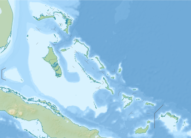
English: Relief map of the Bahamas
Equirectangular projection, N/S stretching 105 %. Geographic limits of the map:
|
| Datum | |
| Izvor |
|
| Autor | Nzeemin |
| Ostale verzije |
|

Licenciranje
Ja, vlasnik autorskog prava ovog djela, ovdje ga objavljujem pod sljedećom licencom:
Ova datoteka je licencirana pod Creative Commons Attribution-Share Alike 3.0 neportiranom licencom.
- Slobodni ste:
- da dijelite – da kopirate, distributirate i prenosite djelo
- da remiksate – da prilagodite djelo
- Pod sljedećim uslovima:
- pripisivanje – Morate pripisati odgovarajuće autorske zasluge, osigurati link ka licenci i naznačiti jesu li napravljene izmjene. To možete uraditi na bilo koji razumni način, ali ne tako da se sugerira da davalac licence odobrava Vas ili Vašu upotrebu njegovog djela.
- dijeli pod istim uslovima – Ako mijenjate, transformišete ili nadograđujete ovaj materijal, morate ga objaviti i distribuirati samo pod istom ili sličnom licencom poput ove.
Historija datoteke
Kliknite na datum/vrijeme da vidite verziju datoteke iz tog vremena.
| Datum/vrijeme | Smanjeni pregled | Dimenzije | Korisnik | Komentar | |
|---|---|---|---|---|---|
| trenutno | 21:06, 20 novembar 2012 | | 780 × 562 (288 KB) | Nzeemin | User created page with UploadWizard |
Upotreba datoteke
Sljedeća stranica koristi ovu datoteku:
Globalna upotreba datoteke
Sljedeći wikiji koriste ovu datoteku:
- Upotreba na als.wikipedia.org
- Upotreba na ar.wikipedia.org
- Upotreba na ast.wikipedia.org
- Upotreba na az.wikipedia.org
- Şablon:Yer xəritəsi Baham adaları
- San Salvador adası
- Abako adaları
- Aklins
- Andros (Baham adaları)
- Böyük Bahama
- Volkers-Ki
- Qreyt-Raqqed-Aylend
- Co-Kis
- İnaqua
- Kruked-Aylend (Baham adaları)
- Ket-Aylend (Baham adaları)
- Mayaquana
- Normans-Key
- Nyu-Providens
- Eksuma
- Elütera
- Eqq-Aylend (Baham adaları)
- Sil-Ki
- Ram-Ki
- Qrand-Ki adası
- Kastavey-Ki
- Piq-Biç
- Berri adaları
- Litl-Stirrap-Ki
- Upotreba na be.wikipedia.org
- Upotreba na bg.wikipedia.org
- Upotreba na bn.wikipedia.org
- Upotreba na ceb.wikipedia.org
- Upotreba na cs.wikipedia.org
- Upotreba na da.wikipedia.org
Pogledajte globalne upotrebe ove datoteke.
Metapodaci
Text is available under the CC BY-SA 4.0 license; additional terms may apply.
Images, videos and audio are available under their respective licenses.
Cover photo is available under {{::mainImage.info.license.name || 'Unknown'}} license.
Cover photo is available under {{::mainImage.info.license.name || 'Unknown'}} license.
Credit:
(see original file).
