পুনাখা
| পুনাখা སྤུ་ན་ཁ་ | |
|---|---|
 পুনাখা জং, মো নদীর পাশে | |
 পুনাখা | |
| স্থানাঙ্ক: ২৭°৩৭′ উত্তর ৮৯°৫২′ পূর্ব / ২৭.৬১৭° উত্তর ৮৯.৮৬৭° পূর্ব | |
| Country | |
| জেলা | পুনাখা জেলা |
| উচ্চতা | ৪,৩০০ ফুট (১,৩১০ মিটার) |
| সময় অঞ্চল | বিটিটি (ইউটিসি+৬) |
পুনাখা (জংখা: སྤུ་ན་ཁ་) ভূটানের একটি শহর এবং পুনাখা জেলার প্রশাসনিক কেন্দ্র। পুনাখা ১৯৫৫ খ্রিষ্টাব্দ পর্যন্ত ভুটানের রাজধানী এবং সরকারের আসন ছিল, যখন রাজধানী থিম্পুতে সরানো হয়েছিল।[১][২][৩] এটা থিম্পু থেকে ৭২ কিলোমিটার দূরে অবস্থিত এবং রাজধানী থিম্পু থেকে পুনাখাতে গাড়ীতে আসতে প্রায় ৩ ঘণ্টা সময় লাগে। এখানের আবহাওয়া শীতকালে বেশ উষ্ণ এবং গ্রীষ্মকালে গরম হয়। এটা সমুদ্রতল থেকে ১৩১০ মিটার উচ্চতায় অবস্থিত। এখানে ধান প্রধান ফসল হিসেবে চাষ করা হয়। এখানে ভুটানি ভাষাই সাধারণত বলা হয়।
পুনাখা জং
[সম্পাদনা]পুনাখা ডিজং (পুংতাং ডিছেন ফোটরাং জং হিসেবেও পরিচিত) (যার অর্থ পরম সুখময় প্রাসাদ [১][৪]) পুনাখা শহরের একটি প্রাচীন প্রাসাদ। প্রাসাদটি ১৬৩৭-৩৮ সালে যাবদ্রারং রিনপোছে দ্বারা নির্মিত হয়েছিল যার স্থপতি ছিলেন নাগাওয়াং নামগিয়াল।[৪][৫] এটি জং স্থাপত্যশিল্পের দ্বিতীয় পুরাতনতম এবং দ্বিতীয় বৃহত্তম প্রাসাদ এবং তাদের নির্মিত রাজকীয় প্রাসাদগুলো অন্যতম একটি।[২][৪] জং এর এই প্রাসাদে তিব্বতীয় বৌদ্ধধর্মের কাগ্যু গোত্রের দক্ষিণ দ্রুকপা বংশীয়সহ রাংজুং কাসারপানি বংশীয় সাধকদের দেহাবশেষ রয়েছে। এটাকে ভুটানের ঐতিহ্য হিসাবে অন্তর্ভুক্ত করেছে ইউনেস্কো।
১৯০৭ সালে, ভুটানের প্রথম রাজা হিসেবে উগয়েন ওয়াংচুক এর অভিষেক পুনাখা জং-এ হয়। তিন বছর পরে, পুনাখায় একটি চুক্তি হয় যার দ্বারা ব্রিটিশ ভুটানের অভ্যন্তরীণ বিষয়ে হস্তক্ষেপ না করায় সম্মতি জানায় এবং ভুটান ব্রিটেনকে তার পররাষ্ট্র বিষয়ক নির্দেশ করার অনুমতি দেয়।
১৯৮৭ সালে জংটি আংশিকভাবে অগ্নি দ্বারা ধ্বংস হয়।
পুনাখা জং-এর অবস্থান ফো এবং মো নদীর মোহনায়। এই কারণে হিমবাহ হ্রদ থেকে ফ্ল্যাশ ফ্লাডের (আকস্মিক বন্যার) দ্বারা ওখানে আঘাত হওয়ার সম্ভাবনা সৃষ্ট হয়। একটি সাম্প্রতিক রিপোর্ট অনুযায়ী আকস্মিক বন্যা ১৯৫৭, ১৯৬০ এবং ১৯৯৪ সালে পুনাখা জংকে ক্ষতিগ্রস্ত করে।[৬] সম্প্রতি নদীখাত গভীর করে এবং চারটি বৃহৎ বাষ্প হাতা ব্যবহারের দ্বারা বাঁধ উত্থাপন করে জংকে রক্ষা করা হয়েছে যাতে ভবিষ্যতে বন্যা হলে জংএর ক্ষয়ক্ষতি না হয়।

একটি আবৃত কাঠের খিলান সেতু মো নদী পারাপারের জন্য সঙ্গে একসঙ্গে নির্মিত হয়েছিল। এই সেতু ১৯৫৭ বা ১৯৫৪ সালে একটি আকস্মিক বন্যায় গুড়িয়ে যায়। ২০০৬ সালে একটি নতুন আবৃত কাঠের খিলান নির্মাণ করার কাজ শুরু হয়। জার্মানদের সহায়তায় ২০০৮ সালে সম্পূর্ণ হয় সেতুটি। সেতুটি ৫৫ মিটর ফ্রী স্প্যান নিয়ে তৈরী হয়। সেতুর নির্মাণে ভূটানের ঐতিহ্য ফুটিয়ে তোলা হয়েছে।[৭]
চিত্রশালা
[সম্পাদনা]-
 পুনাখা জং এবং পুনাখা উপত্যকা
 -
 পুনাখা জং
 -
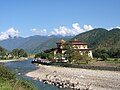
 পুনাখা জং এবং মো নদী


আরো দেখুন
[সম্পাদনা]তথ্যসূত্র
[সম্পাদনা]- ↑ ক খ Wangchuck, Ashi Dorji Wangmo (২০০৬)। Treasures of the thunder dragon: a portrait of Bhutan। Penguin, Viking। পৃষ্ঠা 40–41, 102। আইএসবিএন 0-670-99901-6। সংগ্রহের তারিখ ২০১০-০৪-০১।
- ↑ ক খ "Punakha Dzong"। Tourism:Government of Bhutan। ২০১৭-০৯-০৭ তারিখে মূল থেকে আর্কাইভ করা। সংগ্রহের তারিখ ২০১০-০৪-০১।
- ↑ Brown, Lindsay; Bradley Mayhew; Stan Armington; Richard Whitecros (২০০৭)। Bhutan। Lonely Planet। পৃষ্ঠা 146–147। আইএসবিএন 1-74059-529-7। সংগ্রহের তারিখ ২০১০-০৪-০১।
- ↑ ক খ গ "Dzong at Punakha"। সংগ্রহের তারিখ ২০১০-০৪-০১।
The second oldest dzong in Bhutan, it was begun in 1637 also on the order of Shabdrung Ngawang Namgyal. The dzong was significantly expanded from 1744 to 1763 during the reign of the 13th desi (the secular ruler, as opposed to the Je Khenpo, who is the chief abbot of Bhutan, and who holds equal power), Sherab Wangchuk.
- ↑ Pommaret, Francoise (২০০৬)। Bhutan Himalayan Mountains Kingdom (5th edition)। Odyssey Books and Guides। পৃষ্ঠা 192।
- ↑ Chhopel, Karma (২০০৬-০৩-১৫)। "Flash Floods and Debris Flows due to Glacial Lake Outburst Floods" (ppt)। Proceedings of the International Workshop on Flash Flood Forecasting coordinated by the U.S. National Oceanic and Atmospheric Administration's National Weather Service and the World Meteorological Organization, San José, Costa Rica, March 2006। Conference web site (NOAA), Abstract (pdf)। Thimphu, Bhutan: Hydro-Met Services Division, Dept. of Energy, Ministry of Trade and Industry।
- ↑ Nestroy, H. N. (২০০৮)। "Re-construction of the Cantilever Bridge crossing the Mochhu (Mo-River) connecting Punakha village and Punakha Dzong in adapted traditional Bhutanese architecture."। Pro Bhutan e.v.। ২০০৯-০৪-০৫ তারিখে মূল থেকে আর্কাইভ করা। সংগ্রহের তারিখ ২০০৯-০১-২৩।
Text is available under the CC BY-SA 4.0 license; additional terms may apply.
Images, videos and audio are available under their respective licenses.
