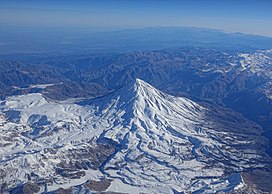
দামভান্দ পর্বত
| দামভান্দ دماوند | |
|---|---|
 দক্ষিণ-পশ্চিম থেকে দামাভান্ড দেখা যায় | |
| সর্বোচ্চ বিন্দু | |
| উচ্চতা | ৫,৬০৯.২ মিটার (১৮,৪০৩ ফুট) [১][২]টেমপ্লেট:Disputed inline[৩] |
| সুপ্রত্যক্ষতা | ৪,৬৬৭ মিটার (১৫,৩১২ ফুট) [২][৪] Ranked 12th |
| প্রধান শিখর | Mount Elbrus [৫] |
| বিচ্ছিন্নতা | ১,১৬৫ কিমি (৭২৪ মা) |
| তালিকাভুক্তি | আগ্নেয়গিরি সেভেন সামিট সর্বোচ্চ পয়েন্ট অনুসারে দেশগুলির তালিকা আলট্রা বিশিষ্ট শীর্ষ |
| স্থানাঙ্ক | ৩৫°৫৭′২০″ উত্তর ৫২°০৬′৩৬″ পূর্ব / ৩৫.৯৫৫৫৬° উত্তর ৫২.১১০০০° পূর্ব [৪] |
| ভূগোল | |
| অবস্থান | আমোল, মজানদারান, ইরান |
| মূল পরিসীমা | আলবার্জ - মাজান্দ্রান |
| ভূতত্ত্ব | |
| পর্বতের ধরন | স্ট্র্যাটোভলকানো |
| সর্বশেষ অগ্ন্যুত্পাত | ৫৩৫০ বিসিই ± ২০০ বছর |
| আরোহণ | |
| প্রথম আরোহণ | আবু দোলাফ কাজরাজী কর্তৃক ৯০৫ সালে [৬] |
| সহজ পথ | হাইকিং |
দামভান্দ পর্বত (ফার্সি: کوه دماوند) উত্তর ইরানে তেহরান শহরের কাছে অবস্থিত একটি সক্রিয় আগ্নেয়গিরি। এটি হিমালয়ের পরই এশিয়ার সর্বোচ্চ পর্বতশৃঙ্গ।[৭] সমুদ্র সমতল থেকে এর উচ্চতা ৫,৬৭০ মিটার। এটি এলবুর্জ পর্বতমালার সর্বোচ্চ শৃঙ্গ এবং এশিয়া মহাদেশের সর্বোচ্চ আগ্নেয়গিরি। পর্বতশৃঙ্গটি কোণকাকৃতির এবং এর জ্বালামুখ এখনও অপরিবর্তিত রয়েছে। পর্বতটির পাদদেশে অনেক উষ্ম পানির ঝর্ণা আছে, যার অর্থ এর ভেতর এখনও বেশ উত্তপ্ত। ১৮৩৭ সালে ইউরোপীয় অভিযাত্রী ডব্লিউ টেইলর টমসন এটির শীর্ষে প্রথম আরোহণ করেন। দামভান্দ শহরের কাছেই অবস্থিত দামভান্দ শহর একটি জনপ্রিয় গ্রীষ্মকালীন অবকাশ যাপন কেন্দ্র।
ইরানের সাহিত্যে দামভান্দ পর্বত কিংবদন্তির মর্যাদাপ্রাপ্ত।
তথ্যসূত্র
[সম্পাদনা]- ↑ "Geography of Iran"। ২০১৫-০১-১৭ তারিখে মূল থেকে আর্কাইভ করা। সংগ্রহের তারিখ ২০২০-০২-২৪।
- ↑ ক খ "Kuh-e Damavand" - Iran Ultra Prominence peaklist.org. Retrieved 16 October 2011
- ↑ 2009 U.S. military topographic mapping gives 18,365 feet (5,598 meters) but states in the margin that all elevations are derived from SRTM. A summitpost map is based on the Persian language 1999 Iranian government 1:50,000 mapping which plots two 5620 contour circles, with a 5628 m spot height for the highest spot on the crater rim (WNW side) and 5626 m for the highest point on the southeast side (and a 5610 m spot height in the due north position.) This is supported by GPS evidence and SRTM data.
- ↑ ক খ টেমপ্লেট:Cite pb
- ↑ Pona, Georgia - Key col for Damavand peakbagger.com. Retrieved 29 January 2016
- ↑ "SummitPost: Damavand"। সংগ্রহের তারিখ ২০১০-০৪-২৮।
- ↑ "কালের কণ্ঠ, ১৫ ফেব্রুয়ারি ২০১৭"। ১৯ জুন ২০১৯ তারিখে মূল থেকে আর্কাইভ করা। সংগ্রহের তারিখ ১৯ জুন ২০১৯।
এশিয়ার সর্বোচ্চ বিন্দু | |
|---|---|
| সার্বভৌম রাষ্ট্রসমূহ |
|
| সীমিত স্বীকৃতিপ্রাপ্ত রাষ্ট্রসমূহ |
|
| পরাধীন এবং অন্যান্য অঞ্চল |
|
Text is available under the CC BY-SA 4.0 license; additional terms may apply.
Images, videos and audio are available under their respective licenses.

