ট্রেন্ট নদী
| ট্রেন্ট নদী River Trent | |
|---|---|
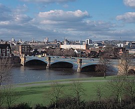
 ট্রেন্ট সেতু (ট্রেন্ট ব্রিজ), পটভূমিতে নটিংহাম শহর দেখা যাচ্ছে। | |
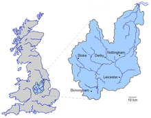
 ট্রেন্ট নদীব্যবস্থা দ্বারা বিধৌত অববাহিকা | |
| অবস্থান | |
| রাষ্ট্র | যুক্তরাজ্য |
| রাজ্য (দেশ) | ইংল্যান্ড |
| কাউন্টিসমূহ | স্ট্যাফোর্ডশায়ার, ডার্বিশায়ার, লেস্টারশায়ার, নটিংহামশায়ার, লিংকনশায়ার, ইয়র্কশায়ার |
| নগরীসমূহ | স্টোক-অন-ট্রেন্ট, নটিংহাম |
| শহরসমূহ | স্টোন, বার্টন আপন ট্রেন্ট, নিউয়ার্ক-অন-ট্রেন্ট, গেইনসবরো |
| প্রাকৃতিক বৈশিষ্ট্য | |
| উৎস | |
| • অবস্থান | বিডলফ মুর, স্ট্যাফোর্ডশায়ার, ইংল্যান্ড |
| • স্থানাঙ্ক | ৫৩°০৬′৫৮″ উত্তর ০২°০৮′২৫″ পশ্চিম / ৫৩.১১৬১১° উত্তর ২.১৪০২৮° পশ্চিম |
| • উচ্চতা | ২৭৫ মি (৯০২ ফু) |
| মোহনা | |
• অবস্থান | ট্রেন্ট ফলস, হাম্বার মোহনা, লিংকনশায়ার, ইংল্যান্ড |
• স্থানাঙ্ক | ৫৩°৪২′০৩″ উত্তর ০০°৪১′২৮″ পশ্চিম / ৫৩.৭০০৮৩° উত্তর ০.৬৯১১১° পশ্চিম |
• উচ্চতা | ০ মি (০ ফু) |
| দৈর্ঘ্য | ২৯৮ কিমি (১৮৫ মা) |
| অববাহিকার আকার | ১০,৪৩৫ কিমি২ (৪,০২৯ মা২)[১][ক] |
| নিষ্কাশন | |
| • অবস্থান | Colwick[৩] |
| • গড় | ৮৪ মি৩/সে (৩,০০০ ঘনফুট/সে)[৩] |
| • সর্বনিম্ন | ১৫ মি৩/সে (৫৩০ ঘনফুট/সে)[৩][খ] |
| • সর্বোচ্চ | ১,০১৮ মি৩/সে (৩৬,০০০ ঘনফুট/সে)[৪][গ] |
| নিষ্কাশন | |
| • অবস্থান | North Muskham |
| • গড় | ৮৮ মি৩/সে (৩,১০০ ঘনফুট/সে) |
| অববাহিকার বৈশিষ্ট্য | |
| উপনদী | |
| • বামে | Blithe, Swarbourn, Dove, Derwent, Erewash, Leen, Greet, Idle, Torne |
| • ডানে | Sow, Tame, Mease, Soar, Devon, Eau |
| গতিপথ : ট্রেন্ট নদী — হাম্বার — উত্তর সাগর | |

ট্রেন্ট নদী (ইংরেজি: River Trent) উত্তর-পশ্চিম ইউরোপের রাষ্ট্র যুক্তরাজ্যের একটি নদী। নদীটি ইংল্যান্ড রাজ্যের পশ্চিমভাগে স্ট্যাফোর্ডশায়ার অঞ্চলে উৎপত্তিলাভ করে দক্ষিণ-পূর্ব দিকে (মিডল্যান্ডস প্রশাসনিক অঞ্চলের উত্তর ও মধ্যভাগ দিয়ে) প্রবাহিত হয়ে স্টোক-অন-ট্রেন্ট শহরকে অতিক্রম করে ডার্বিশায়ার কাউন্টির সীমান্তের দিকে চলে গেছে এবং সেখানে উত্তর ও উত্তর-পূর্ব দিকে মোড় নিয়ে বার্টন-আপন-ট্রেন্ট ও নটিংহাম শহরের পাশ দিয়ে প্রবাহিত হয়ে ট্রেন্ট ফল্স নামক স্থানে উজ নদীর সাথে মিলিত হয়ে হাম্বার নদী বা মোহনাটি গঠন করেছে। হাম্বার মোহনাটি উত্তর সাগরে গিয়ে পতিত হয়েছে। ট্রেন্ট নদী যুক্তরাজ্যের তৃতীয় দীর্ঘতম নদী (সেভার্ন নদী এবং টেমস নদীর পরেই)। এর দৈর্ঘ্য ২৯৮ কিমি (১৮৫ মা)। নদীটির গতিপথকে প্রায়শই উত্তর ইংল্যান্ড এবং মিডল্যান্ডের মধ্যবর্তী সীমানা হিসেবে বর্ণনা করা হয়েছে।[৫][৬]
তথ্যসূত্র
[সম্পাদনা]- ↑ Trent River Authority. Official Handbook of the Trent River Authority. Cheltenham and London:Ed. J. Burrow and Co. Ltd, 1972.
- ↑ "Midlands Catchment Flood Management Plans"। Environment Agency। সংগ্রহের তারিখ ১১ এপ্রিল ২০১৩।
- ↑ ক খ গ "28009 – Trent at Colwick"। The National River Flow Archive। Centre for Ecology & Hydrology। সংগ্রহের তারিখ ২৪ মার্চ ২০১৩।
- ↑ "Hi Flows UK"। Environment Agency। সংগ্রহের তারিখ ৪ মার্চ ২০১৩।
- ↑ James R. Penn (২০০১)। Rivers of the World: A Social, Geographical, and Environmental Sourcebook। ABC-CLIO। পৃষ্ঠা 107–8। আইএসবিএন 978-1-57607-042-0।
- ↑ Clare Bambra (৩০ আগস্ট ২০১৬)। Health Divides: Where You Live Can Kill You। Policy Press। পৃষ্ঠা 73–6। আইএসবিএন 978-1-4473-3035-6।
উদ্ধৃতি ত্রুটি: "lower-alpha" নামক গ্রুপের জন্য <ref> ট্যাগ রয়েছে, কিন্তু এর জন্য কোন সঙ্গতিপূর্ণ <references group="lower-alpha"/> ট্যাগ পাওয়া যায়নি
Text is available under the CC BY-SA 4.0 license; additional terms may apply.
Images, videos and audio are available under their respective licenses.
