Файл:1956 map of the Kapidag Peninsula (cropped).tif

Размер на този JPG предварителен преглед на изходния TIF файл: 626 × 599 пиксела. Други разделителни способности: 251 × 240 пиксела | 501 × 480 пиксела | 802 × 768 пиксела | 1070 × 1024 пиксела | 1336 × 1279 пиксела.
Оригинален файл (1336 × 1279 пиксела, големина на файла: 4,91 МБ, MIME-тип: image/tiff)
| Този файл е от Общомедия и може да се използва от други проекти.
Следва информация за файла, достъпна през оригиналната му описателна страница. |
Резюме
| Описание |
English: Turkey-Greece, Canakkale, Series: K502, Sheet NK 35-11, 1956, 1:250 000 |
| Дата | |
| Източник | https://openresearch-repository.anu.edu.au/handle/1885/160269 |
| Автор | Prepared by Army Map Service (AMNS), Corps of Engineers, US Army, Washington, D.C. Published by War Office |
| други версии |

Лицензиране
This file is a work of a U.S. Army soldier or employee, taken or made as part of that person's official duties. As a work of the U.S. federal government, it is in the public domain in the United States.
|
 |
История на файла
Избирането на дата/час ще покаже как е изглеждал файлът към онзи момент.
| Дата/Час | Миникартинка | Размер | Потребител | Коментар | |
|---|---|---|---|---|---|
| текуща | 21:16, 18 юни 2020 | 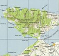 | 1336 × 1279 (4,91 МБ) | Balkanique | File:Turkey-Greece, Canakkale, Series, K502, Sheet NK 35-11, 1956, 1 to 250 000.tif cropped 84 % horizontally, 81 % vertically using CropTool with precise mode. |
Използване на файла
Следната страница използва следния файл:
Глобално използване на файл
Този файл се използва от следните други уикита:
- Употреба в en.wikipedia.org
- Употреба в tr.wikipedia.org
Метаданни
Text is available under the CC BY-SA 4.0 license; additional terms may apply.
Images, videos and audio are available under their respective licenses.
Cover photo is available under {{::mainImage.info.license.name || 'Unknown'}} license.
Cover photo is available under {{::mainImage.info.license.name || 'Unknown'}} license.
Credit:
(see original file).
