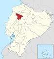
Файл:Santo Domingo de los Tsachilas in Ecuador (+Galapagos).svg

Арыгінальны файл (файл SVG, намінальна 512 × 551 кропак, аб’ём файла: 259 KB)
Гісторыя файла
Націснуць на даце з часам, каб паказаць файл, якім ён тады быў.
| Дата і час | Драбніца | Памеры | Удзельнік | Тлумачэнне | |
|---|---|---|---|---|---|
| актуальн. | 06:28, 26 верасня 2017 |  | 512 × 551 (259 KB) | Berposen | The limits of the province of Santo Domingo were out of place. |
| 12:16, 16 лістапада 2011 |  | 1 535 × 1 654 (704 KB) | TUBS |
Выкарыстанне файла
Наступная 1 старонка выкарыстоўвае гэты файл:
Глабальнае выкарыстанне файла
Гэты файл выкарыстоўваецца ў наступных вікі:
- Выкарыстанне ў ar.wikipedia.org
- Выкарыстанне ў bg.wikipedia.org
- Выкарыстанне ў ca.wikipedia.org
- Выкарыстанне ў de.wikipedia.org
- Выкарыстанне ў en.wikipedia.org
- Выкарыстанне ў eo.wikipedia.org
- Выкарыстанне ў es.wikipedia.org
- Выкарыстанне ў eu.wikipedia.org
- Выкарыстанне ў fa.wikipedia.org
- Выкарыстанне ў fi.wikipedia.org
- Выкарыстанне ў frr.wikipedia.org
- Выкарыстанне ў fr.wikipedia.org
- Выкарыстанне ў hy.wikipedia.org
- Выкарыстанне ў ia.wikipedia.org
- Выкарыстанне ў id.wikipedia.org
- Выкарыстанне ў incubator.wikimedia.org
- Выкарыстанне ў it.wikipedia.org
- Выкарыстанне ў ja.wikipedia.org
- Выкарыстанне ў ko.wikipedia.org
- Выкарыстанне ў lad.wikipedia.org
- Выкарыстанне ў lb.wikipedia.org
- Выкарыстанне ў lv.wikipedia.org
- Выкарыстанне ў nl.wikipedia.org
- Выкарыстанне ў pl.wikipedia.org
- Выкарыстанне ў pt.wikipedia.org
- Выкарыстанне ў qu.wikipedia.org
- Выкарыстанне ў ru.wikipedia.org
- Выкарыстанне ў sh.wikipedia.org
- Выкарыстанне ў simple.wikipedia.org
- Выкарыстанне ў sv.wikipedia.org
- Выкарыстанне ў uk.wikipedia.org
- Выкарыстанне ў ur.wikipedia.org
- Выкарыстанне ў war.wikipedia.org
- Выкарыстанне ў www.wikidata.org
- Выкарыстанне ў zh-min-nan.wikipedia.org
- Выкарыстанне ў zh.wikipedia.org
Метаданыя
Text is available under the CC BY-SA 4.0 license; additional terms may apply.
Images, videos and audio are available under their respective licenses.


