Файл:Europe subregion map UN geoscheme.svg

Памер гэтага PNG-прагляду для SVG-файла: 680 × 520 пікселяў. Іншыя разрозненні: 314 × 240 пікселяў | 628 × 480 пікселяў | 1 004 × 768 пікселяў | 1 280 × 979 пікселяў | 2 560 × 1 958 пікселяў.
Арыгінальны файл (файл SVG, намінальна 680 × 520 кропак, аб’ём файла: 228 KB)
Тлумачэнне
| Апісанне |
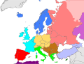
Deutsch: Subregionen Europas (nach UN Geoschema)
Nordeuropa
Westeuropa
Osteuropa
Südeuropa English: Subregions of Europe (UN geoscheme)
Northern Europe
Western Europe
Eastern Europe
Southern Europe
Countries of West Asia with partial territory in Southern Europe: Turkey
Countries of West Asia with partial territory in Eastern Europe: Georgia and Azerbaijan
Countries of Central Asia with partial territory in Eastern Europe: Kazakhstan
Русский: Макрорегионы Европы (классификация ООН)
Северная Европа
Западная Европа
Восточная Европа
Южная Европа
Страны макрорегиона Западная Азия с частичной территорией в Южной Европе: Турция
Страны макрорегиона Западная Азия с частичной территорией в Восточной Европе: Азербайджан и Грузия
Страны макрорегиона Центральная Азия с частичной территорией в Восточной Европе: Казахстан
Українська: Підрегіони Європи (класифікація Організації Об’єднаних Націй)
Північна Європа
Західна Європа
Східна Європа
Південна Європа Країни Західної Азії з частиною території в Південній Європі: Туреччина
Країни Західної Азії з частиною території в Східній Європі: Грузія та Азербайджан
Країни Центральної Азії з частиною території в Східній Європі: Казахстан
|
| Дата |
|
| Крыніца |
Уласная праца |
| Аўтар |
Kolja21 |
|Source=Уласная праца |Author=Kolja21 |Date=2009-05-23 |Permission= |other_versions=Derivative works of this file:
-
 Subregions of Europe
(World Factbook) -
 Subregions of Europe
(UN geoschme) -
 Geografische und politische Grenzen Europas (2007) - DE
 -
 Political geography of Europe (2007) - EN
 -
 European Union
 -
 EU as a single entity
 -
 EU on a globe
 -
 EC-EU enlargement (animated)
 -
 Eastern Partnership
 -
 EU, EFTA and Eastern Partnership
 -
 EU membership possible


_de.png)
.png)


))
Ліцэнзіяванне
Я, уладальнік аўтарскіх правоў на гэты твор, добраахвотна публікую яго на ўмовах наступнай ліцэнзіі:
Гэты файл даступны па ліцэнзіі Creative Commons Пазначэнне аўтарства 3.0 Непартаваная
- Вы можаце свабодна:
- дзяліцца творам – капіраваць, распаўсюджваць і перадаваць гэты твор.
- ствараць вытворныя творы – адаптаваць гэты твор
- Пры выкананні наступных умоў:
- атрыбуцыя – вы павінны пазначыць аўтарства гэтага твора, даць спасылку на ліцэнзію і пазначыць ці рабіў аўтар якія-небудзь змены. Гэта можна рабіць кожным зразумелым чынам, але не так, каб наводзіць па думку, што ліцэнзіят падтрымлівае вас або выкарыстанне вамі гэтага твора.
Гісторыя файла
Націснуць на даце з часам, каб паказаць файл, якім ён тады быў.
| Дата і час | Драбніца | Памеры | Удзельнік | Тлумачэнне | |
|---|---|---|---|---|---|
| актуальн. | 16:50, 9 лістапада 2021 | | 680 × 520 (228 KB) | TU-nor | Reverted to version as of 12:17, 22 February 2021 (UTC) No reason to color countries that are outside Europe in the Geosceme unless they are geographically transcontinental |
| 03:12, 6 жніўня 2021 |  | 680 × 520 (262 KB) | Vesperius | Cleanup at the edges. | |
| 02:53, 6 жніўня 2021 |  | 680 × 520 (238 KB) | Vesperius | Cyprus and Armenia included. | |
| 15:17, 22 лютага 2021 |  | 680 × 520 (228 KB) | TU-nor | Andorra is Southern Europe in UN geoscheme | |
| 14:17, 23 верасня 2015 |  | 680 × 520 (572 KB) | Alex Great | Reverted to version as of 09:22, 1 June 2014 | |
| 12:48, 10 ліпеня 2015 |  | 744 × 1 052 (430 KB) | Andrej500 | Crimea | |
| 12:22, 1 чэрвеня 2014 |  | 680 × 520 (572 KB) | Insider | Russian Sochi Sector in Asia | |
| 21:50, 27 мая 2009 |  | 680 × 520 (571 KB) | Kolja21 | ((Information |Description=((en|1=Subregions of Europe (UN geoschme))) ((de|1=Subregionen Europas (nach UN Geoschema))) |Source=Eigenes Werk (own work) |Author=Kolja21 |Date=2009-05-23 |Permission= |other_ |
Выкарыстанне файла
Наступныя 3 старонкі выкарыстоўваюць гэты файл:
Глабальнае выкарыстанне файла
Гэты файл выкарыстоўваецца ў наступных вікі:
- Выкарыстанне ў af.wikipedia.org
- Выкарыстанне ў am.wikipedia.org
- Выкарыстанне ў ar.wikipedia.org
- Выкарыстанне ў av.wikipedia.org
- Выкарыстанне ў awa.wikipedia.org
- Выкарыстанне ў azb.wikipedia.org
- Выкарыстанне ў ba.wikipedia.org
- Выкарыстанне ў bn.wikipedia.org
- Выкарыстанне ў br.wikipedia.org
- Выкарыстанне ў ce.wikipedia.org
- Выкарыстанне ў cs.wikipedia.org
- Выкарыстанне ў cv.wikipedia.org
- Выкарыстанне ў cy.wikipedia.org
- Выкарыстанне ў de.wikipedia.org
- Выкарыстанне ў diq.wikipedia.org
- Выкарыстанне ў el.wikipedia.org
- Выкарыстанне ў en.wikipedia.org
Паказаць глабальнае выкарыстанне гэтага файла.
Метаданыя
Text is available under the CC BY-SA 4.0 license; additional terms may apply.
Images, videos and audio are available under their respective licenses.
Cover photo is available under {{::mainImage.info.license.name || 'Unknown'}} license.
Cover photo is available under {{::mainImage.info.license.name || 'Unknown'}} license.
Credit:
(see original file).
