Файл:GermanAustriaMap.png
Памер прагляду: 800 × 579 піксэлаў. Іншыя разрозьненьні: 320 × 232 піксэлаў | 640 × 463 піксэлаў | 1024 × 741 піксэлаў | 1280 × 926 піксэлаў | 1520 × 1100 піксэлаў.
Арыгінальны файл (1520 × 1100 піксэляў, памер файла: 285 кб, тып MIME: image/png)
Гэты файл паходзіць зь Вікісховішча. Зьвесткі пра гэты файл зь яго старонкі апісаньня прыведзеныя ніжэй. Вікісховішча — сховішча вольных мэдыяфайлаў. Вы можаце дапамагчы. |
Апісаньне
| Апісаньне | |
| Дата | |
| Крыніца |
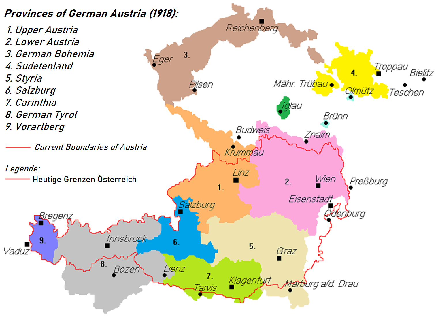
Гэты файл — вытворны твор ад: Deutschösterreich.PNG |
| Аўтар | Postmann Michael, AjaxSmack |

|
This map has been uploaded by Electionworld from en.wikipedia.org to enable the |
Areas 3 and 4 are transposed: Sudetenland is the area shown West and Silesia in the East
Ліцэнзія
| Гэтая праца была перададзеная ў грамадзкі набытак яе аўтарам, AjaxSmack. Дазвол сапраўдны для ўсяго сьвету. У некаторых краінах гэта ня можа быць юрыдычна магчыма; калі так, то: |
Гісторыя файла
Націсьніце на дату/час, каб паглядзець, як тады выглядаў файл.
| Дата і час | Мініятура | Памеры | Удзельнік | Камэнтар | |
|---|---|---|---|---|---|
| цяперашняя | 23:05, 16 ліпеня 2021 | | 1520 × 1100 (285 кб) | Kontrollstellekundl | brighter colours, better resolution |
| 05:15, 28 ліпеня 2018 |  | 788 × 560 (27 кб) | AjaxSmack | Reverted to version as of 07:16, 16 June 2017 (UTC); note text at de:Datei:Deutschösterreich.PNG | |
| 23:42, 24 сьнежня 2017 |  | 788 × 560 (27 кб) | Mélomène | Colors | |
| 10:16, 16 чэрвеня 2017 |  | 788 × 560 (27 кб) | Valdemar | Reichenberg is really cs:Liberec | |
| 00:43, 18 лютага 2014 |  | 788 × 560 (23 кб) | Kirk979 | correction | |
| 00:23, 18 лютага 2014 |  | 788 × 560 (20 кб) | Kirk979 | correction | |
| 18:50, 29 сьнежня 2011 |  | 788 × 560 (31 кб) | Fext | Fixed location of Reichenberg (Liberec) | |
| 01:49, 24 сьнежня 2006 |  | 788 × 560 (23 кб) | Electionworld | ((ew|en|AjaxSmack)) == Summary == Based on: de:Bild:Deutschösterreich.PNG == Licensing == ((PD-user|AjaxSmack)) |
Выкарыстаньне файла
Наступныя старонкі выкарыстоўваюць гэты файл:
Глябальнае выкарыстаньне файла
Гэты файл выкарыстоўваецца ў наступных вікі:
- Выкарыстаньне ў ar.wikipedia.org
- Выкарыстаньне ў ast.wikipedia.org
- Выкарыстаньне ў azb.wikipedia.org
- Выкарыстаньне ў az.wikipedia.org
- Выкарыстаньне ў ba.wikipedia.org
- Выкарыстаньне ў be.wikipedia.org
- Выкарыстаньне ў ca.wikipedia.org
- Выкарыстаньне ў cs.wikipedia.org
- Выкарыстаньне ў da.wikipedia.org
- Выкарыстаньне ў el.wikipedia.org
- Выкарыстаньне ў en.wikipedia.org
- Выкарыстаньне ў et.wikipedia.org
- Выкарыстаньне ў fa.wikipedia.org
- Выкарыстаньне ў fi.wikipedia.org
- Выкарыстаньне ў fr.wikipedia.org
- Выкарыстаньне ў he.wikipedia.org
- Выкарыстаньне ў hu.wikipedia.org
- Выкарыстаньне ў hy.wikipedia.org
- Выкарыстаньне ў it.wikipedia.org
- Выкарыстаньне ў ka.wikipedia.org
- Выкарыстаньне ў ko.wikipedia.org
- Выкарыстаньне ў lt.wikipedia.org
- Выкарыстаньне ў lv.wikipedia.org
- Выкарыстаньне ў mk.wikipedia.org
Паказаць глябальнае выкарыстаньне гэтага файла.
Мэтазьвесткі
Text is available under the CC BY-SA 4.0 license; additional terms may apply.
Images, videos and audio are available under their respective licenses.
Cover photo is available under {{::mainImage.info.license.name || 'Unknown'}} license.
Cover photo is available under {{::mainImage.info.license.name || 'Unknown'}} license.
Credit:
(see original file).
