Ruderatshofen
| Woppn | Deitschlandkoatn | |
|---|---|---|

|
Koordinaten: 47° 49′ N, 10° 35′ O | |
| Basisdotn | ||
| Bundesland: | Bayern | |
| Regiarungsbeziak: | Schwobm (Bayern) | |
| Landkroas: | Ostallgai | |
| Vawoitungsgmoaschoft: | Biessenhofen | |
| Hechn: | 728 m ü. NHN | |
| Flächn: | 33,52 km2 | |
| Eihwohna: | 1755 (31. Dez. 2020)[1] | |
| Bevökarungsdichtn: | 52 Einwohner je km2 | |
| Postleitzoi: | 87674 | |
| Voawoi: | 08343 | |
| Autokennzeichn: | OAL, FÜS, MOD | |
| Gmoaschlissl: | 09 7 77 167 | |
| Address vo da Gmoavawoitung: |
Füssener Str. 12 87640 Biessenhofen | |
| Webseitn: | ||
| Buagamoasta: | Johann Stich (Allg. Wählergem. Apfeltrang) | |
| Log vo da Gmoa Ruderatshofen im Ostallgai | ||
 | ||


Ruderatshofen is a Gmoa im schwäbischn Landkroas Ostallgai und Mitglied daVawoitungsgmoaschoft Biessenhofen.
Geografie
[Werkeln | Am Gwëntext werkeln]Ruderatshofen liegt in da Region Allgai. Es existian foignde Gemarkunga: Apfeltrang und Ruderatshofen. Weitare Ortsteil san Elbsee, Geisenhofen, Heimenhofen, Hiemenhofen, Immenhofen und Leichertshofen.
Eigmoadunga
[Werkeln | Am Gwëntext werkeln]Am 1. Mai 1978 is de bis dohi sejbstständige Gmoa Apfeltrang eigliedat worn.[2]
Ausgliedarunga
[Werkeln | Am Gwëntext werkeln]Am 1. Jenna 1982 hod se da Apfeltranger Ortstei Wenglingen duach Voiksentscheid vo da Gmoa glest und is an de GmoaAitrang obtretn worn.[2]
Eihwohnaentwicklung
[Werkeln | Am Gwëntext werkeln]Ruderatshofen is zwischn 1988 und 2008 um 340 Eihwohna bzw. ca. 24 % gwochsn.
Galerie
[Werkeln | Am Gwëntext werkeln]-
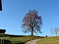
ApfeltrangApfeltrang
-
 Immenhofen Linde bei da Kirch
 -
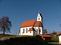 Immenhofen Kirch
 -
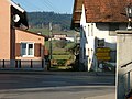 Ruderatshofen Ortsmittn
 -
 Friedhof sidli vo Ruderatshofen
 -
 Ruderatshofen vo Ostn
 -
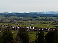 Ruderatshofen vo da Bergmangalpe aus


Im Netz
[Werkeln | Am Gwëntext werkeln]- Ruderatshofen: Woppmgschicht vom Haus der Bayerischen Geschichte
- Ruderatshofen: Amtliche Statistik vom Bayerisches Landesamt für Statistik und Datenverarbeitung (LStDV) (PDF; 1,05 MB)
Beleg
[Werkeln | Am Gwëntext werkeln]- ↑ Genesis Online-Datenbank des Bayerischen Landesamtes für Statistik Tabelle 12411-001 Fortschreibung des Bevölkerungsstandes: Gemeinden, Stichtage (letzten 6) (Einwohnerzahlen auf Grundlage des Zensus 2011) (Hilfe dazu).
- ↑ 2,0 2,1 2,2 2,3 Statistisches Bundesamt (Hrsg.): Historisches Gemeindeverzeichnis für die Bundesrepublik Deutschland. Namens-, Grenz- und Schlüsselnummernänderungen bei Gemeinden, Kreisen und Regierungsbezirken vom 27. 5. 1970 bis 31. 12. 1982. W. Kohlhammer GmbH, Stuttgart/Mainz 1983, ISBN 3-17-003263-1, S. 779 und 815.
Text is available under the CC BY-SA 4.0 license; additional terms may apply.
Images, videos and audio are available under their respective licenses.
Cover photo is available under {{::mainImage.info.license.name || 'Unknown'}} license.
Cover photo is available under {{::mainImage.info.license.name || 'Unknown'}} license.
Credit:
(see original file).
