Datei:Yellowstone Caldera map2.jpg
Gress dea Voaschau: 743 × 600 Pixel Weitere Auflésungan: 298 × 240 Pixel | 595 × 480 Pixel | 952 × 768 Pixel | 1.269 × 1.024 Pixel | 2.538 × 2.048 Pixel | 3.072 × 2.479 Pixel.
Version in hechara Auflesung (3.072 × 2.479 Pixel, Dateigress: 2,42 MB, MIME-Typ: image/jpeg)

|
Dieses Bild des Typs Geology sollte als Vektorgrafik im SVG-Format neu erstellt werden. Vektorformate haben zahlreiche Vorteile; weitere Information unter Commons:Media for cleanup. Wenn dir eine SVG-Version dieses Bildes vorliegt, so lade diese bitte hoch. Nach dem Hochladen der Datei ist diese Vorlage auf der aktuellen Bildbeschreibungsseite durch die Vorlage ((Vector version available)), oder kürzer ((Vva)), zu ersetzen. Es ist empfohlen die neue SVG-Datei „Yellowstone Caldera map2.svg“ zu nennen – dann benötigt die Vorlage vector version available (bzw. vva) keinen Parameter.
|


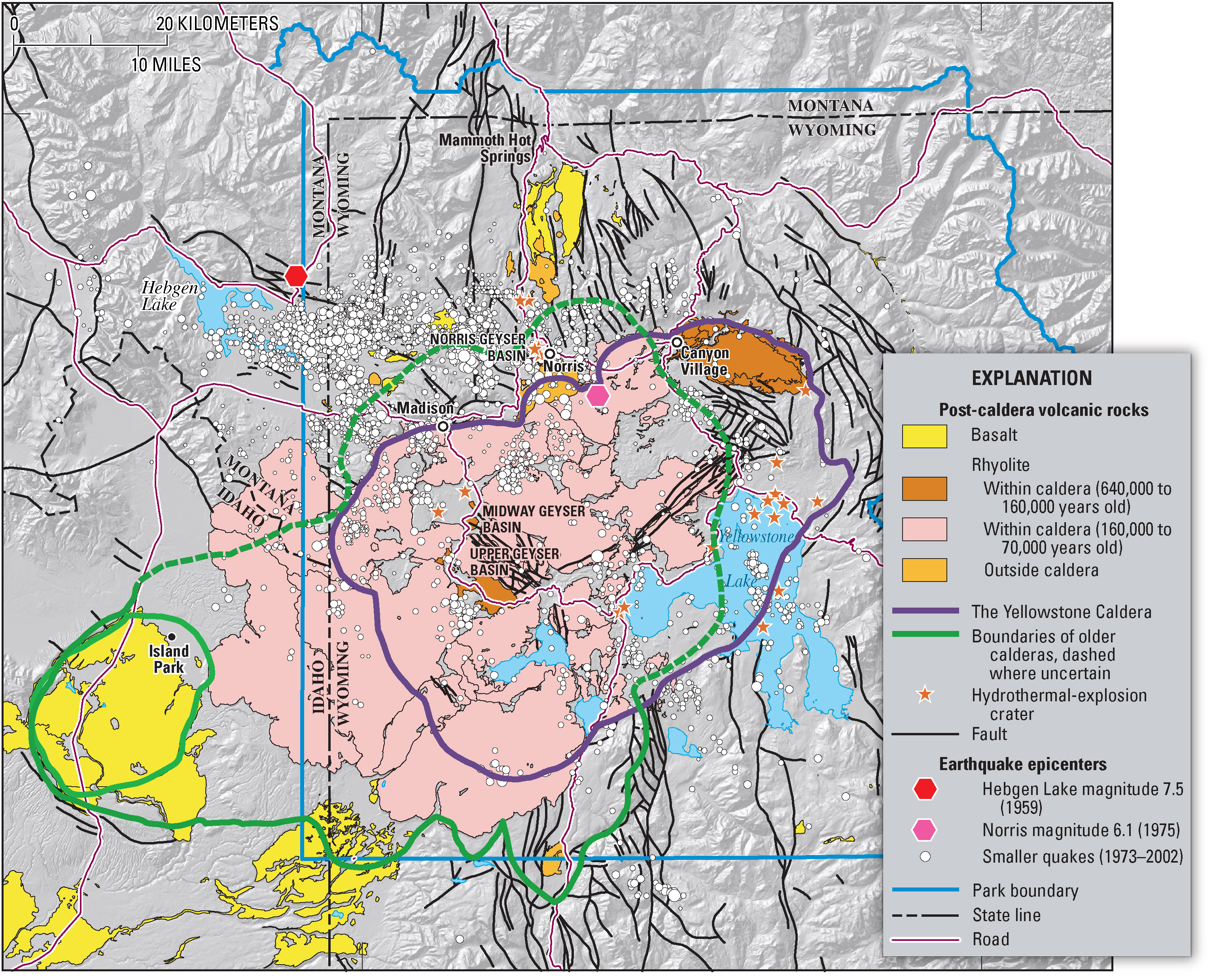
Geologic information regarding Yellowstone Caldera. From USGS. [1]
Dieses Bild ist gemeinfrei (public domain), weil es Materialien beeinhaltet, die ursprünglich vom United States Geological Survey, einer Behörde des Innenministeriums der Vereinigten Staaten, stammen. Weitere Informationen finden Sie in den Urheberrechtsbestimmungen des USGS
|
Dateiversiona
Wensd auf an Zeitpunkt klickst, nacha konst a friaane Version lodn.
| Version vom | Vorschaubuidl | Dimensióna | Nutzer | Kommentar | |
|---|---|---|---|---|---|
| aktuell | 09:49, 16. Few. 2006 | | 3.072 × 2.479 (2,42 MB) | Napa | Geologic information regarding Yellowstone Caldera. From USGS. [http://pubs.usgs.gov/fs/2005/3024/press-images/fig_03_yellowstone_map.jpg] ((PD-USGov-Interior-USGS)) Category:Geography of the United States Category:Maps of the United States |
Dateivawendung
Seitn wo de Datei nutzn:
Globale Dateinutzung
D'noochéfóiganden åndern Wikis vawénden dé Datei:
- Vawendung af ar.wikipedia.org
- Vawendung af ast.wikipedia.org
- Vawendung af de.wikipedia.org
- Vawendung af en.wikipedia.org
- Vawendung af fi.wikipedia.org
- Vawendung af fr.wikipedia.org
- Vawendung af he.wikipedia.org
- Vawendung af it.wikipedia.org
- Vawendung af kk.wikipedia.org
- Vawendung af ms.wikipedia.org
- Vawendung af nl.wikipedia.org
- Vawendung af nl.wikibooks.org
- Vawendung af oc.wikipedia.org
- Vawendung af pl.wikipedia.org
- Vawendung af uk.wikipedia.org
- Vawendung af www.wikidata.org
Metadaten
Text is available under the CC BY-SA 4.0 license; additional terms may apply.
Images, videos and audio are available under their respective licenses.
Cover photo is available under {{::mainImage.info.license.name || 'Unknown'}} license.
Cover photo is available under {{::mainImage.info.license.name || 'Unknown'}} license.
Credit:
(see original file).
