Datei:Map Transsib Railway 1897.png
Gress dea Voaschau: 800 × 401 Pixel Weitere Auflésungan: 320 × 160 Pixel | 640 × 320 Pixel | 1.024 × 513 Pixel | 1.280 × 641 Pixel | 2.223 × 1.113 Pixel.
Version in hechara Auflesung (2.223 × 1.113 Pixel, Dateigress: 717 KB, MIME-Typ: image/png)
Bschreiwung
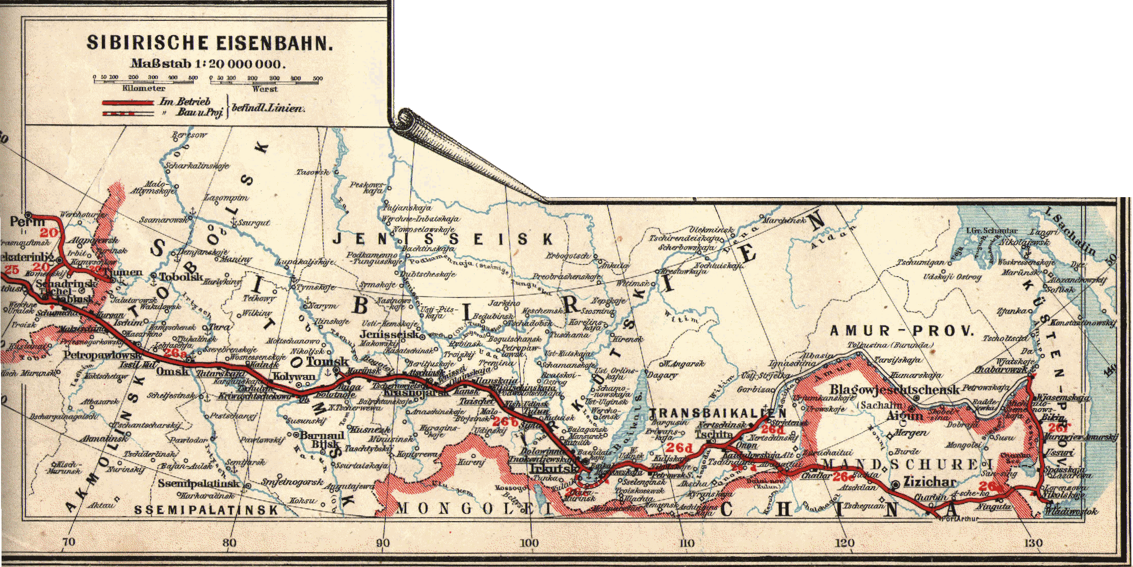
| Bschreiwung | Historical map of the Transsiberian Railway |
| Daatum | |
| Quejn | Eisenbahn- und Verkehrsatlas von Europa |
| Urhéwer | Der geographischen Anstalt von J.J. Arnd in Leipzig |
| Gnémigung (Weidernutzung voh derer Daatei) |
PD - the company does not exist any more |
| Aundre Versióner |
Lizenz
|
Des Buidl oda de Mediendatei is gmoafrei, wei dii urhebarechtliche Schutzfrist obgelaffa is. Des guilt fir ålle Staatn mit a gsetzlichn Schutzfrist vo 70 Jåhr oda weniga nachm Tod vom Urheba. | |
| Es wurde festgestellt, dass diese Datei frei von bekannten Beschränkungen durch das Urheberrecht ist, alle verbundenen und verwandten Rechte eingeschlossen. | |
Dateiversiona
Wensd auf an Zeitpunkt klickst, nacha konst a friaane Version lodn.
| Version vom | Vorschaubuidl | Dimensióna | Nutzer | Kommentar | |
|---|---|---|---|---|---|
| aktuell | 20:31, 22. Few. 2007 | | 2.223 × 1.113 (717 KB) | BjørnN | |
| 19:50, 22. Few. 2007 |  | 2.340 × 1.652 (727 KB) | BjørnN | ((Information |Description=Historical map of the Transsiberian Railway |Source=Eisenbahn- und Verkehrsatlas von Europa |Date=1897 |Author=Der geographischen Anstalt von J.J. Arnd in Leipzig |Permission=PD - the company does not exist any more |other_versi |
Dateivawendung
Seitn wo de Datei nutzn:
Globale Dateinutzung
D'noochéfóiganden åndern Wikis vawénden dé Datei:
- Vawendung af de.wikipedia.org
- Vawendung af fi.wikipedia.org
- Vawendung af ja.wikipedia.org
- Vawendung af nds.wikipedia.org
- Vawendung af nl.wikipedia.org
- Vawendung af no.wikipedia.org
Text is available under the CC BY-SA 4.0 license; additional terms may apply.
Images, videos and audio are available under their respective licenses.
Cover photo is available under {{::mainImage.info.license.name || 'Unknown'}} license.
Cover photo is available under {{::mainImage.info.license.name || 'Unknown'}} license.
Credit:
(see original file).
