Файл:Basse Mesopotamie DA.PNG
Юғары айырыусанлыҡтағы өлгө юҡ.
Basse_Mesopotamie_DA.PNG ((440 × 393 пиксель, файл күләме: 158 КБ, MIME-төр: image/png))
Был файл һаҡлау урыны Викиһаҡлағыста һаҡлана. Уның тураһында мәғлүмәттәр түбәндә күрһәтелгән.
Викиһаҡлағыс — Викимедиа проекттарында ҡулланылған ирекле файлдар өсөн үҙәкләштерелгән һаҡлағыс. |
| Тасуирлау |
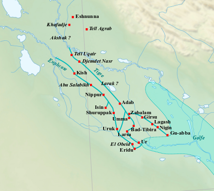
English: Map of the main cities of Lower Mesopotamia during the Early Dynastic period, with the approximate course of the rivers and the ancient shoreline of the Gulf. Français : Carte des principales villes de la Basse Mésopotamie durant la période des Dynasties Archaïques, avec le tracé approximatif des fleuves et l'ancien trait de côte du Golfe. |
| Көнө | (UTC) |
| Сығанаҡ | |
| Автор |
|
| Это отретушированное изображение, что означает, что первоначальная версия изображения была изменена цифровым способом. Изменения: Ajout du tracé approximatif des fleuves et du trait de côté du Golfe, et de villes.. Оригинал доступен по ссылке: Near East topographic map-blank.svg:
|
Мин, был эшкә авторлыҡ хоҡуҡтары эйәһе, үҙ теләгем менән уны түбәндәге лицензиялар шарттарына ярашлы баҫтырып сығарам:
Файл Creative Commons нигеҙендә-шул уҡ шарттар менән 3.0 Дөйөм, 2.5 Дөйөм, 2.0 Дөйөм һәм 1.0 Дөйөм лицензиялары буйынса ҡулланыла.
- Һеҙгә мөмкин:
- бүлешергә – эште күсереп алырға, таратырға һәм тапшырырға
- үҙгәртергә – эште яраҡлаштырырға
- Түбәндәге шарттарҙа:
- авторлыҡты асыҡлау – Авторлыҡты, лицензияға һылтанманы һәм авторҙың ниндәй ҙә булһа үҙгәрештәр индергәнме-юҡмы икәнлеген күрһәтергә тейешһегеҙ. Быны теләһә ниндәй ысул менән эшләргә мөмкин, әммә лицензиат һеҙгә ярҙам иткән йәки ошо әҫәрҙе ҡулланыуығыҙҙы хуплаған тигән тойғо тыуырға тейеш түгел.
- шул уҡ шарттарҙа – Әгәр һеҙ был әҫәрҙе үҙгәртәһегеҙ, уның нигеҙендә яңы әҫәр яҙаһығыҙ икән, сығанаҡ әҫәр рөхсәтнамәһен йәки шуға тура килә торған лицензия ҡулланырға тейешһегеҙ.

|
Был документты Ирекле программа тәьминәте фонды тарафынан баҫтырылған GNU Free Documentation License рөхсәтнамәһенең 1.2 йәки һуңғыраҡ өлгөһө шарттарына ярашлы даими бүлектәрһеҙ, тәүге һәм аҙаҡҡы тышлыҡтарға урынлаштырыла торған текстарһыҙ күсереп алыу, таратыу һәм/йәки үҙгәртеү рөхсәт ителә. Рөхсәтнамәнең күсермәһен GNU Free Documentation License бүлегендә ҡарағыҙ. |
Һеҙ лицензияның үҙегеҙ теләгәнен һайлай алаһығыҙ.
Төп йөкләүҙәр журналы
This image is a derivative work of the following images:
- File:Near_East_topographic_map-blank.svg licensed with Cc-by-sa-3.0,2.5,2.0,1.0, GFDL
- 2009-08-18T18:31:37Z Sémhur 2425x1581 (2442670 Bytes) 3 - New try
- 2009-08-17T15:39:22Z Sémhur 2425x1581 (1815374 Bytes) 2 - With the background...
- 2009-08-17T15:37:36Z Sémhur 2425x1581 (2836 Bytes) ((Information |Description=((en|1=Blank physical map of the [[:en:Near East|Near East]])) ((fr|1=Carte physique vierge du [[:fr:Proche-Orient|Proche-Orient]].)) |Source=((own)) |Author=[[User:Sémhur|Sémhur]] |Date=2008-08-1
Uploaded with derivativeFX
Файл тарихы
Файлдың күрһәтелгән ваҡытта ниндәй өлгөлә булғанын ҡарар өсөн баҫығыҙ: Дата/ваҡыт
| Дата/ваҡыт | Миниатюра | Үлсәмдәре | Ҡатнашыусы | Иҫкәрмә | |
|---|---|---|---|---|---|
| ағымдағы | 22:44, 17 февраль 2023 | | 440 × 393 (158 КБ) | Zunkir | cote et cours d'eau |
| 18:20, 4 февраль 2018 |  | 440 × 393 (181 КБ) | Zunkir | Tracé des cours d'eau, locations sites. | |
| 12:04, 28 сентябрь 2010 |  | 1021 × 730 (817 КБ) | Zunkir | ((Information |Description=((en|1=Map of the main cities of Lower Mesopotamia during the Early Dynastic period, with the approximate course of the rivers and the ancient shoreline of the Gulf.)) ((fr|1=Carte des principales villes de la Basse Mésopotamie |
Файл ҡулланыу
Был файлды киләһе бит ҡуллана:
Файлды глобаль ҡулланыу
Был файл түбәндәге википроекттарҙа ҡулланыла:
- af.wikipedia.org проектында ҡулланыу
- ar.wikipedia.org проектында ҡулланыу
- arz.wikipedia.org проектында ҡулланыу
- ast.wikipedia.org проектында ҡулланыу
- az.wikipedia.org проектында ҡулланыу
- be.wikipedia.org проектында ҡулланыу
- ca.wikipedia.org проектында ҡулланыу
- cs.wikipedia.org проектында ҡулланыу
- cy.wikipedia.org проектында ҡулланыу
- de.wikipedia.org проектында ҡулланыу
- diq.wikipedia.org проектында ҡулланыу
- en.wikipedia.org проектында ҡулланыу
- eo.wikipedia.org проектында ҡулланыу
- es.wikipedia.org проектында ҡулланыу
- eu.wikipedia.org проектында ҡулланыу
- fa.wikipedia.org проектында ҡулланыу
- fi.wikipedia.org проектында ҡулланыу
- fr.wikipedia.org проектында ҡулланыу
Был файлды глобаль ҡулланыуҙы ҡарарға.
Text is available under the CC BY-SA 4.0 license; additional terms may apply.
Images, videos and audio are available under their respective licenses.
Cover photo is available under {{::mainImage.info.license.name || 'Unknown'}} license.
Cover photo is available under {{::mainImage.info.license.name || 'Unknown'}} license.
Credit:
(see original file).
