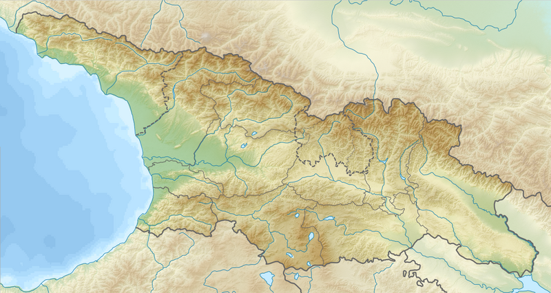
Fayl:Relief Map of Georgia.png
Vikipediya, azad ensiklopediya

Faylın orijinalı (1.182 × 629 piksel, fayl həcmi: 1,08 MB, MIME növü: image/png)
Faylın tarixçəsi
Faylın əvvəlki versiyasını görmək üçün gün/tarix bölməsindəki tarixlərə klikləyin.
| Tarix/Vaxt | Miniatür | Ölçülər | İstifadəçi | Şərh | |
|---|---|---|---|---|---|
| hal-hazırkı | 20:49, 25 iyul 2016 |  | 1.182 × 629 (1,08 MB) | NordNordWest | missing border between Guria and Samegrelo-Zemo Svaneti added |
| 19:22, 26 avqust 2010 |  | 1.182 × 629 (1,22 MB) | Виктор В | ==((int:filedesc))== ((Information |Description=((en|Relief map of Georgia)) Equirectangular projection, N/S stretching 135 %. Geographic limits of the map: * N: 43.7° N * S: 40.9° N * W: 39.8° E * E: 46.9° E |Source=*[[:File |
Faylın istifadəsi
Aşağıdakı 80 səhifə bu faylı istifadə edir:
- Abastumani astrofizika rəsədxanası
- Abxaz silsiləsi
- Aktaş gölü
- Algeti Milli Parkı
- Anaxatır
- Arabika
- Asxi yaylası
- Axalkalaki zəlzələsi
- Azameti idarə olunan qoruğu
- Ağ at mağarası
- Aşağı Kartli düzənliyi
- Bazaleti gölü
- Borjomi-Xaraqauli Milli Parkı
- Brest qalası mağarası
- Böyük Borbalo dağı
- Böyük Əbül dağı
- Daşbaşı Kanyonu Təbiət abidəsi
- Devdorak buzlağı
- Dzirula çayı
- Dəlidağ (Samsar silsiləsi)
- Ertso gölü
- Jinvali su anbarı
- Kazbek dağı
- Keli gölü
- Kelsk platosu
- Kiçik Qafqaz
- Kiçik Əbül dağı
- Kluxor aşırımı
- Kobuleti Qoruğu
- Kolxida Milli Parkı
- Kolxida ovalığı
- Krubera mağarası
- Kumisi gölü
- Kumistavi mağarası
- Kvedi gölü
- Kvirila çayı
- Laqodexi qoruğu
- Liaxvi qoruğu
- Lisi gölü
- Madatapa gölü
- Mamison aşırımı
- Mavi göl (Gürcüstan)
- Mesxeti silsiləsi
- Mtirala Milli Parkı
- Okatse kanyonu təbiət abidəsi
- Oxkur silsiləsi
- Paleostomi gölü
- Paravani gölü
- Pisunda burnu
- Pitsunda körfəzi
- Qaqra silsiləsi
- Qori zəlzələsi
- Raçin silsiləsi
- Rikoti aşırımı
- Ritsa Sərt Təbiət Qoruğu
- Rok aşırımı
- Sakajia mağarası
- Samsar dağı
- Samsar silsiləsi
- Sağamo gölü
- Tabatsğuri gölü
- Tbilisi Milli Parkı
- Tbilisi su anbarı
- Tiflis Dəmiryol Stansiyası
- Tmoqvin zəlzələsi (1088)
- Trialet silsiləsi
- Tsalka su anbarı
- Tuşeti Milli Parkı
- Tısbağa gölü
- Uşba
- Vaşlovani Milli Parkı
- Veryovkin mağarası
- Xançali gölü
- Yeni Afon mağarası
- İnkit gölü
- İnquri SES
- Şiraki düzənliyi
- Şxara dağı
- İstifadəçi müzakirəsi:Toghrul R/Arxiv 2
- Şablon:Yer xəritəsi Gürcüstan
Faylın qlobal istifadəsi
Bu fayl aşağıdakı vikilərdə istifadə olunur:
- als.wikipedia.org layihəsində istifadəsi
- ast.wikipedia.org layihəsində istifadəsi
- av.wikipedia.org layihəsində istifadəsi
- ba.wikipedia.org layihəsində istifadəsi
- be-tarask.wikipedia.org layihəsində istifadəsi
- be.wikipedia.org layihəsində istifadəsi
- bn.wikipedia.org layihəsində istifadəsi
- bs.wikipedia.org layihəsində istifadəsi
- ca.wikipedia.org layihəsində istifadəsi
- ceb.wikipedia.org layihəsində istifadəsi
Bu faylın qlobal istifadəsinə baxın.
Metaməlumatlar
Text is available under the CC BY-SA 4.0 license; additional terms may apply.
Images, videos and audio are available under their respective licenses.


