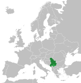
Serbia y Montenegru
| |||||
|---|---|---|---|---|---|
| estáu desapaecíu | |||||
| |||||
| Himnu nacional |
Hej Sloveni (es) | ||||
| Alministración | |||||
| Nome oficial | Државна Заједница Србија и Црна Гора | ||||
| Capital | Belgráu | ||||
| Forma de gobiernu |
república federal (hasta 2003) xunión política República parllamentaria | ||||
| Llingües oficiales | Serbiu | ||||
| Miembru de |
ver
| ||||
| Xeografía | |||||
| Coordenaes | 43°09′N 19°47′E / 43.15°N 19.78°E | ||||
 | |||||
| Superficie | 102,350 km² (puestu 105) | ||||
| % agua | 0.25% | ||||
| Costes | n/d | ||||
| Llenda con | n/d | ||||
| Demografía | |||||
| Población | 10,829,175 (2005 est.) hab. | ||||
| Densidá | Error d'espresión: Operador ( inesperáu hab/km² | ||||
| Xentiliciu | |||||
| Economía | |||||
| Moneda |
dinar yugoslavu, dinar serbio (es) | ||||
| Más información | |||||
| Códigu ISO | 891 / SCG / ensin valor y CS | ||||
| Estaya horaria | UTC+01:00 | ||||
Serbia y Montenegru foi un estáu federal allugáu nos Balcanes, socesor direutu de Yugoslavia y formáu poles repúbliques autónomes de Serbia y Montenegru. Llendaba al norte con Hungría, al este con Rumanía y Bulgaria, al sur con Macedonia y Albania y al oeste col Mar Adriáticu y con Bosnia y Herzegovina. La so capital federal yera Belgráu.
Dende'l referendu d'autodetermín de Montenegru, el 21 de mayu de 2006, entamóse'l procesu de dixebra de la federación.
Xeografía
[editar | editar la fonte]División política:
- Serbia (capital: Belgráu)
- Vojvodina - (capital: Novi Sad)
- Montenegru (capital: Podgorica)
Kosovu ye un proteutoráu de la ONX instauráu tres d'una guerra, entendío como illegal por munchos xuristes de drechu internacional. Anque protexida pola ONX, dende estremaos seutores acúsase qu'esta rexón ta ocupada por fuercies militares compuestes por albano-kosovares.
Demografía
[editar | editar la fonte]
Grupos étnicos principales
- Serbios: 66%
- Montenegrinos: 5%
- Albaneses: 16,5%
- Húngaros: 3,3%
Datos xenerales
Población (2005): 10.600.000 (Serbia: 9.981.929, Montenegru: 620.000)
Estructura d'edá (2005):
- 0-14 años: 19,95% (Serbia), 22,05% (Montenegru)
- 15-64 años: 65,22% (Serbia), 66,16% (Serbia)
- 65 años o más: 14,83% (Serbia), 11,79% (Montenegru)
Medra de población (2000): -0,739% (Serbia), -12,22% (Montenegru)
Mortalidá infantil: 20,13 (Serbia), 10,97 (Montenegru) por 1000 nacencies
Esperanza de vida: 72,39 (Serbia), 75,46 (Montenegru) años

Cultura
[editar | editar la fonte]
Referencies
[editar | editar la fonte]Enllaces esternos
[editar | editar la fonte] Wikimedia Commons tien conteníu multimedia tocante a Serbia y Montenegru.
- Páxina oficial del gobiernu de Serbia y Montenegru
- B92
- RTS
- Krstarica
- Burek Forum
Text is available under the CC BY-SA 4.0 license; additional terms may apply.
Images, videos and audio are available under their respective licenses.


