Formentin
 | |
| Alministración | |
| País | |
| Organización territorial | Francia metropolitana |
| Rexón | |
| Departamentu | |
| Distritu | Distrito de Lisieux (es) |
| Cantón | Cantón de Cambremer (es) |
| Tipu d'entidá | comuña de Francia |
| Nome oficial | Formentin (fr)[1] |
| Códigu postal |
14340 |
| Xeografía | |
| Coordenaes | 49°11′52″N 0°08′29″E / 49.1978°N 0.1414°E |
 | |
| Superficie | 5.93 km² |
| Altitú | 74 m[2] y 154 m[2] |
| Llenda con | Auvillars, Bonnebosq, Clarbec, Le Fournet, Manerbe, Saint-Hymer y Le Torquesne |
| Demografía | |
| Población |
267 hab. (1r xineru 2021) - 128 homes (2017) - 122 muyeres (2017) |
| Porcentaxe |
100% de Cantón de Cambremer (es) |
| Densidá | 45,03 hab/km² |
| Más información | |
| Estaya horaria |
UTC+01:00 (horariu estándar) UTC+02:00 (horariu de branu) |
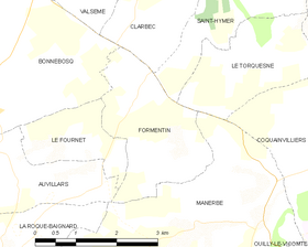
Formentin ye una comuña francesa del departamentu de Calvados, na rexón de Normandía. Llenda con Auvillars, Bonnebosq, Clarbec, Le Fournet, Manerbe, Saint-Hymer y Le Torquesne.
Tien una población de 267 hab. (1 xineru 2021)[3][4] y una superficie de 5,93[5] km².
Referencies
[editar | editar la fonte]- ↑ «code officiel géographique». Consultáu'l 6 xineru 2019.
- ↑ 2,0 2,1 Tienes d'especificar urlarchivu = y fechaarchivu = al usar ((cita web)).«répertoire géographique des communes». Institut national de l'information géographique et forestière (2015).
- ↑ Afirmao en: Populations légales 2021. Data d'espublización: 28 avientu 2023. Editorial: Institut national de la statistique et des études économiques.
- ↑ censu de población
- ↑ Afirmao en: répertoire géographique des communes. Data de consulta: 26 ochobre 2015. Editorial: Institut national de l'information géographique et forestière.
Enllaces esternos
[editar | editar la fonte] Formentin n'OpenStreetMap.
 Formentin n'OpenWeatherMap
Text is available under the CC BY-SA 4.0 license; additional terms may apply.
Images, videos and audio are available under their respective licenses.

