Ficheru:World of Ptolemy as shown by Johannes de Armsshein - Ulm 1482.png
Tamañu d'esta previsualización: 800 × 582 pixels. Otres resoluciones: 320 × 233 pixels | 640 × 465 pixels | 1024 × 744 pixels | 1168 × 849 pixels.
Ficheru orixinal (1168 × 849 píxels, tamañu de ficheru: 2,97 MB, triba MIME: image/png)
| Artista |
Lord Nicolas the German (Donnus Nicholas Germanus), cartographer Johann the Blockcutter of Armsheim (Johannes Schnitzer or Johannes de Armsheim), engraver |
||||
| Autor | |||||
| Descripción |
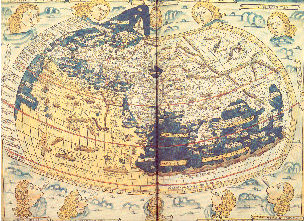
English: The world map from a 1482 edition of Nicolaus Germanus's emendations to Jacobus Angelus's 1406 Latin translation of Maximus Planudes's late-13th century rediscovered Greek manuscripts of Ptolemy's 2nd-century Geography.
Français : On ne possède aucune carte de Ptolémée. Celle que nous reproduisons a été gravée sur bois à Ulm en 1482 par Johannes de Armsheim dont le nom est porté dans la marge supérieure. Conçue comme une sphère, la Terre comporte les trois continents de l'Antiquité : Europe, Asie et Afrique, environ le tiers du monde aujourd'hui connu. Les vents représentés par des têtes aux cheveux blonds soufflent sur la Terre. |
||||
| Fonte/Fotógrafu | Extrait du périscope "La cartographie", éditions PEMF - CANNES | ||||
| Permisu (Cómo reutilizar esti ficheru) |
Ce document vous est offet par les Publications de l'Ecole moderne française, BP109-06322 CANNES-LA BOCCA CEDEX (sentence refering to the source document itself)
|
||||
| Otres versiones |
|
||||


Historial del ficheru
Calca nuna fecha/hora pa ver el ficheru como taba daquella.
| Data/Hora | Miniatura | Dimensiones | Usuariu | Comentariu | |
|---|---|---|---|---|---|
| actual | 14:22 8 xnt 2006 | | 1168 × 849 (2,97 MB) | Holycharly~commonswiki | ((Information |Description= Historical Map of the Old World, as en:Ptolemy knew it.<br/> Backcover description from the scanned document :<br/> :''On ne possède aucune carte de Ptolémée. Celle que nous reproduisons a été gravée sur bois à Ulm |
Usu del ficheru
Les páxines siguientes usen esti ficheru:
Usu global del ficheru
Estes otres wikis usen esti ficheru:
- Usu en bn.wikipedia.org
- Usu en es.wikipedia.org
- Usu en fr.wikipedia.org
- Usu en fr.wikiversity.org
- Usu en fy.wikipedia.org
- Usu en ga.wikipedia.org
- Usu en id.wikipedia.org
- Usu en ja.wikipedia.org
- Usu en nds-nl.wikipedia.org
- Usu en nl.wikipedia.org
- Usu en uk.wikipedia.org
Text is available under the CC BY-SA 4.0 license; additional terms may apply.
Images, videos and audio are available under their respective licenses.
Cover photo is available under {{::mainImage.info.license.name || 'Unknown'}} license.
Cover photo is available under {{::mainImage.info.license.name || 'Unknown'}} license.
Credit:
(see original file).
