Ficheru:Oesterreich topo.png
Nun ta disponible con mayor resolución.
Oesterreich_topo.png (800 × 564 píxels, tamañu de ficheru: 1,04 MB, triba MIME: image/png)
Resume
| Descripción |
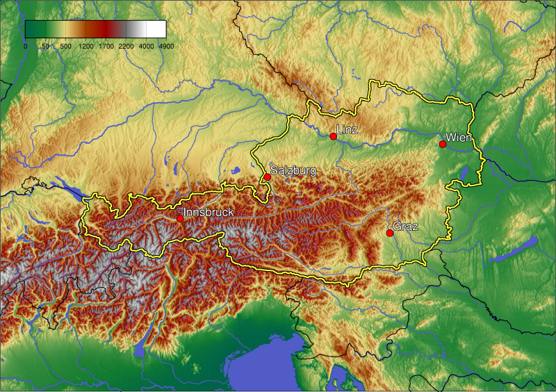
English: Topographic map of Austria.
Deutsch: Topografische Kartei Österreichs.
Lëtzebuergesch: Topographie vun Éisträich |
| Data | |
| Fonte | Trabayu propiu |
| Autor | Themanwithoutapast on en.wikipedia |
Uploaded using CommonsHelper or PushForCommons
Llicencia

|
Autorízase la copia, distribución y/o cambéu d'esti documentu baxo los términos de la Llicencia de documentación llibre GNU, versión 1.2 o cualesquier otra que nel futuru espublice la Free Software Foundation; ensin seiciones invariables, testos de portada, nin testos de contraportada. S'inclúi una copia de la llicencia na seición titulada GNU Free Documentation License. |
| Esti ficheru ta disponible baxo la llicencia Creative Commons Reconocimientu-Compartir igual 3.0 xenérica. | ||
| ||
| Esta etiqueta de llicencia s'amestó a esti ficheru como parte del anovamientu de la llicencia GFDL. |
Historial del ficheru
Calca nuna fecha/hora pa ver el ficheru como taba daquella.
| Data/Hora | Miniatura | Dimensiones | Usuariu | Comentariu | |
|---|---|---|---|---|---|
| actual | 17:58 15 xnt 2006 | | 800 × 564 (1,04 MB) | Civvi~commonswiki | ((Information| |Description= en:Category:Austria maps en:vi:Image:Oesterreich topo.png en:de:Bild:Oesterreich topo.png |Source= |Date= |Author=User Themanwithoutapast on [http://en.wikipedia.org en.wikipedia] |
Usu del ficheru
La páxina siguiente usa esti ficheru:
Usu global del ficheru
Estes otres wikis usen esti ficheru:
- Usu en af.wikipedia.org
- Usu en ar.wikipedia.org
- Usu en azb.wikipedia.org
- Usu en be-tarask.wikipedia.org
- Usu en bg.wikipedia.org
- Usu en bn.wikipedia.org
- Usu en br.wikipedia.org
- Usu en ca.wikipedia.org
- Usu en cs.wikipedia.org
- Usu en cy.wikipedia.org
- Usu en da.wikipedia.org
- Usu en de.wikipedia.org
- Usu en de.wikibooks.org
- Usu en el.wikipedia.org
- Usu en en.wikipedia.org
- Usu en eo.wikipedia.org
- Usu en es.wikipedia.org
- Usu en eu.wikipedia.org
- Usu en fr.wikipedia.org
- Usu en gl.wikipedia.org
- Usu en he.wikipedia.org
- Usu en hr.wikipedia.org
- Usu en hsb.wikipedia.org
- Usu en hu.wikipedia.org
- Usu en hy.wikipedia.org
- Usu en io.wikipedia.org
- Usu en it.wikipedia.org
- Usu en ja.wikipedia.org
- Usu en kn.wikipedia.org
- Usu en la.wikipedia.org
- Usu en lb.wikipedia.org
- Usu en lld.wikipedia.org
- Usu en mk.wikipedia.org
- Usu en nn.wikipedia.org
- Usu en oc.wikipedia.org
- Usu en pam.wikipedia.org
Ver más usos globales d'esti ficheru.
Text is available under the CC BY-SA 4.0 license; additional terms may apply.
Images, videos and audio are available under their respective licenses.
Cover photo is available under {{::mainImage.info.license.name || 'Unknown'}} license.
Cover photo is available under {{::mainImage.info.license.name || 'Unknown'}} license.
Credit:
(see original file).
