Ficheru:Mackenzie River basin map.png
Tamañu d'esta previsualización: 653 × 600 pixels. Otres resoluciones: 261 × 240 pixels | 523 × 480 pixels | 836 × 768 pixels | 1222 × 1122 pixels.
Ficheru orixinal (1222 × 1122 píxels, tamañu de ficheru: 2,11 MB, triba MIME: image/png)
Resume
| Descripción |
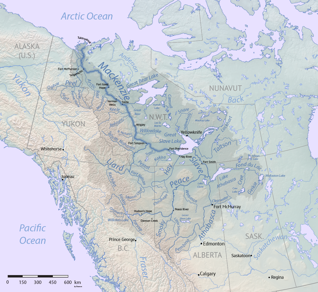
English: Map of the Mackenzie River system in Canada, made using public domain Natural Earth and Atlas of Canada data. |
| Data | |
| Fonte | Trabayu propiu |
| Autor | Shannon1 |
⧼Iicense-header⧽
Yo, el titular de los drechos d'autor d'esta obra, la espublizo baxo les siguientes llicencies:

|
Autorízase la copia, distribución y/o cambéu d'esti documentu baxo los términos de la Llicencia de documentación llibre GNU, versión 1.2 o cualesquier otra que nel futuru espublice la Free Software Foundation; ensin seiciones invariables, testos de portada, nin testos de contraportada. S'inclúi una copia de la llicencia na seición titulada GNU Free Documentation License. |
Si este archivo reúne los requisitos para cambiar de licencia, también puede ser utilizado bajo la licencia Commons Reconocimiento-Compartir Igual 3.0. El estado de autorización de esta imagen todavía no ha sido revisado. Tú puedes ayudar.
|
Este archivo se encuentra bajo la licencia Creative Commons Attribution-Share Alike 3.0 Unported, 2.5 Generic, 2.0 Generic y 1.0 Generic
- Ye llibre:
- pa compartir – pa copiar, distribuir y comunicar públicamente la obra
- pa remezclar – p'adautar la obra
- Baxo les condiciones siguientes:
- reconocimientu – Tienes de dar el créitu apropiáu, apurrir un enllaz a la llicencia ya indicar si realizasti dalgún cambéu. Puedes faelo de cualquier mou razonable ,pero non de manera que suxera l'encontu del autor pa ti o pal usu que faigas.
- compartir igual – Si entemeces, tresformes o te bases nesti material, tienes de distribuir les tos contribuciones baxo la mesma llicencia o una compatible cola orixinal.
Pues seleicionar la llicencia que prefieras.
Historial del ficheru
Calca nuna fecha/hora pa ver el ficheru como taba daquella.
| Data/Hora | Miniatura | Dimensiones | Usuariu | Comentariu | |
|---|---|---|---|---|---|
| actual | 22:34 1 pay 2017 | | 1222 × 1122 (2,11 MB) | Shannon1 | ((Information |Description =((en|1=Map of the Mackenzie River system in Canada, made using public domain Natural Earth and Atlas of Canada data.)) |Source =Own work |Author =Shannon1 |Date =November 1, 201... |
Usu del ficheru
Les páxines siguientes usen esti ficheru:
Usu global del ficheru
Estes otres wikis usen esti ficheru:
- Usu en bh.wikipedia.org
- Usu en cs.wikipedia.org
- Usu en de.wikipedia.org
- Usu en en.wikipedia.org
- Usu en es.wikipedia.org
- Usu en et.wikipedia.org
- Usu en fr.wikipedia.org
- Usu en ja.wikipedia.org
- Usu en ml.wikipedia.org
- Usu en sl.wikipedia.org
- Usu en uz.wikipedia.org
- Usu en xmf.wikipedia.org
Metadatos
Text is available under the CC BY-SA 4.0 license; additional terms may apply.
Images, videos and audio are available under their respective licenses.
Cover photo is available under {{::mainImage.info.license.name || 'Unknown'}} license.
Cover photo is available under {{::mainImage.info.license.name || 'Unknown'}} license.
Credit:
(see original file).
