Ficheru:Dersim districts.png
Tamañu d'esta previsualización: 776 × 600 pixels. Otres resoluciones: 311 × 240 pixels | 621 × 480 pixels | 994 × 768 pixels | 1056 × 816 pixels.
Ficheru orixinal (1056 × 816 píxels, tamañu de ficheru: 30 kB, triba MIME: image/png)
Resume
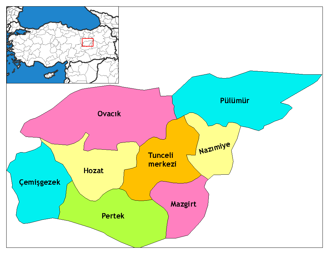
| Descripción | Map of the districts of Tunceli province in Turkey. Created by Rarelibra 17:52, 4 December 2006 (UTC) for public domain use, using MapInfo Professional v8.5 and various mapping resources. Edited by One Homo Sapiens Corrected text where İ,Ş,ı,ğ,or ş occurs in name. Source: [statoids-com]. Increased font size and enhanced color differences among adjacent districts. |
| Data | 4 de avientu de 2006 (fecha original de carga) |
| Fonte | No machine-readable source provided. Own work assumed (based on copyright claims). |
| Autor | No machine-readable author provided. Rarelibra assumed (based on copyright claims). |
Llicencia
| Yo, el titular de los drechos d'autor d'esta obra, la llibero como dominiu públicu. Esto s'aplica nel mundu ensembre. En dellos países seique esto nun seya posible llegalmente; nesti casu: Doi a cualesquier persona permisu pa usar esta obra pa cualesquier propósitu, ensin denguna condición, menos si eses condiciones requierense pola llei. |
Historial del ficheru
Calca nuna fecha/hora pa ver el ficheru como taba daquella.
| Data/Hora | Miniatura | Dimensiones | Usuariu | Comentariu | |
|---|---|---|---|---|---|
| actual | 11:39 8 xun 2014 | | 1056 × 816 (30 kB) | Semsûrî | Changed the name |
| 02:50 29 avi 2008 |  | 1056 × 816 (30 kB) | One Homo Sapiens | Corrected text where İ,Ş,ı,ğ,or ş occurs in name. Source: [statoids-com]. Increased font size and enhanced color differences among adjacent districts. | |
| 17:52 4 avi 2006 |  | 1056 × 816 (30 kB) | Rarelibra | Map of the districts of Tunceli province in Turkey. Created by ~~~~ for public domain use, using MapInfo Professional v8.5 and various mapping resources. |
Usu del ficheru
La páxina siguiente usa esti ficheru:
Usu global del ficheru
Estes otres wikis usen esti ficheru:
- Usu en ar.wikipedia.org
- Usu en arz.wikipedia.org
- Usu en az.wikipedia.org
- Usu en be.wikipedia.org
- Usu en ca.wikipedia.org
- Usu en ceb.wikipedia.org
- Usu en cs.wikipedia.org
- Usu en de.wikipedia.org
- Tunceli
- Mazgirt
- Nazımiye
- Hozat
- Pertek
- Pülümür
- Ovacık (Tunceli)
- Çemişgezek
- Vorlage:Navigationsleiste Landkreise der Provinz Tunceli
- Akdemir (Pertek)
- Aşağıgülbahçe
- Elmakaşı
- Yenisöğüt
- Yaylagünü
- Yarımkaya
- Yakatarla
- Tatuşağı
- Paşadüzü
- Öveçler
- Mollaaliler
- Kozluca
- Koyungölü
- Konaklar (Ovacık)
- Havuzlu
- Güneykonak
- Gözeler
- Eskigedik
- Çöğürlük
- Çemberlitaş
- Çakmaklı
- Büyükköy (Ovacık)
- Aşağıtorunoba
- Arslandoğmuş
- Akyayık
- Yukarıyakabaşı
- Yeniköy (Pertek)
- Tozkoparan
- Pirinççi
- Pınarlar (Pertek)
- Konurat
- Koçpınar
Ver más usos globales d'esti ficheru.
Metadatos
Text is available under the CC BY-SA 4.0 license; additional terms may apply.
Images, videos and audio are available under their respective licenses.
Cover photo is available under {{::mainImage.info.license.name || 'Unknown'}} license.
Cover photo is available under {{::mainImage.info.license.name || 'Unknown'}} license.
Credit:
(see original file).
