For faster navigation, this Iframe is preloading the Wikiwand page for Ficheru:Comoros Mayotte.PNG.

Ficheru:Comoros Mayotte.PNG

Ficheru orixinal(847 × 648 píxels, tamañu de ficheru: 70 kB, triba MIME: image/png)

Esti ficheru ye de Wikimedia Commons y puen usalu otros proyeutos. La descripción de la páxina de descripción del ficheru amuésase darréu.

Descripción
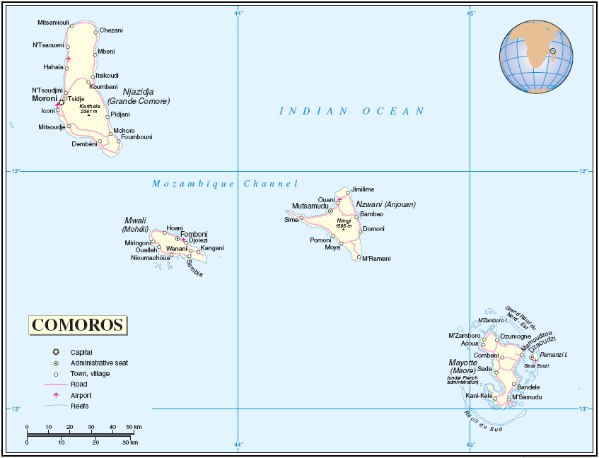
English: Map of the Comoros and Mayotte

About the maps: The United Nations cartographics section claims:

Unless otherwise noted, the maps included on this web site are produced by the Cartographic Section and are copyrighted by the United Nations. Reproduction of any part without the permission of the copyright owner is unlawful. Reproduction of any part without the permission of the copyright owner is unlawful. Please contact us for any questions regarding publication permissions.
Data UTC
Fonte [1]
Autor Thuresson


Public domain Esta imagen es un mapa derivado de producciones de la Sección Cartográfica de las Naciones Unidas.

Las versiones modificadas de mapas de la SCNU (UNCS) podrán utilizarse siempre que el nombre de las Naciones Unidas y el número de referencia que no aparezcan en ninguna versión modificada y se proporcione un enlace al mapa original.
Los mapas modificados de las Naciones Unidas deben ser considerados en el dominio público. Esto aplica globalmente.
Los mapas de las Naciones Unidas son contenido libre. Usted las puede utilizar para hacer tus propios mapas. Usted no necesita nuestro permiso para ello. Tenga en cuenta que el nombre de las Naciones Unidas y el número de referencia no debe aparecer en ningún mapa modificado. El mapa de la ONU es un documento de las Naciones Unidas y no se puede modificar. Puedes decir algo como "Basado en el número de las Naciones Unidas el mapa ..." - Vladimir Bessarabov (Cartógrafo SCNU), 13 de abril 05

Pies

Añade una explicación corta acerca de lo que representa este archivo

Elementos representados en este archivo

representa a

tipo de archivo español

image/png

98ae1e242efa8a7a49eb10ebc7956ba7cb797d31

71 904 Byte

648 píxel

847 píxel

Historial del ficheru

Calca nuna fecha/hora pa ver el ficheru como taba daquella.

Data/HoraMiniaturaDimensionesUsuariuComentariu
actual05:04 26 xnt 2005Miniatura de la versión a fecha de 05:04 26 xnt 2005847 × 648 (70 kB)TaichiMap of Comoros and Mayotte Source: http://www.un.org/Depts/Cartographic/map/profile/comoros.pdf About the maps: The United Nations cartographics section claims: :''Unless otherwise noted, the maps included on this web site are produced by the Cartograph

Usu del ficheru

Les páxines siguientes usen esti ficheru:

Usu global del ficheru

Estes otres wikis usen esti ficheru:

{{bottomLinkPreText}} {{bottomLinkText}}
Ficheru:Comoros Mayotte.PNG
Listen to this article

This browser is not supported by Wikiwand :(
Wikiwand requires a browser with modern capabilities in order to provide you with the best reading experience.
Please download and use one of the following browsers:

This article was just edited, click to reload
This article has been deleted on Wikipedia (Why?)

Back to homepage

Please click Add in the dialog above
Please click Allow in the top-left corner,
then click Install Now in the dialog
Please click Open in the download dialog,
then click Install
Please click the "Downloads" icon in the Safari toolbar, open the first download in the list,
then click Install
{{::$root.activation.text}}

Install Wikiwand

Install on Chrome Install on Firefox
Don't forget to rate us

Tell your friends about Wikiwand!

Gmail Facebook Twitter Link

Enjoying Wikiwand?

Tell your friends and spread the love:
Share on Gmail Share on Facebook Share on Twitter Share on Buffer

Our magic isn't perfect

You can help our automatic cover photo selection by reporting an unsuitable photo.

This photo is visually disturbing This photo is not a good choice

Thank you for helping!


Your input will affect cover photo selection, along with input from other users.

X

Get ready for Wikiwand 2.0 🎉! the new version arrives on September 1st! Don't want to wait?