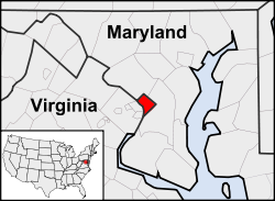
ৱাশ্বিংটন ডি.চি.
| ৱাশ্বিংটন ডি.চি. (Washington, D.C.) | |||
|---|---|---|---|
| — Federal district — | |||
| District of Columbia | |||
| Washington D.C. Montage Proposal 6.jpgTop left: Smithsonian Institution Building; top right: Rock Creek Park; middle: National Mall, including the Lincoln Memorial in the foreground; bottom left: Frederick Douglass National Historic Site; bottom right: Howard Theatre | |||
|
|||
| অন্য নাম: প্ৰধান প্ৰবন্ধ: Nicknames of Washington, D.C. |
|||
| নীতি বাক্য: Justitia Omnibus (ইংৰাজী: Justice for All) | |||
 |
|||
| ভৌগোলিক স্থানাংক: 38°54′17″N 77°00′59″W / 38.90472°N 77.01639°Wস্থানাংক: 38°54′17″N 77°00′59″W / 38.90472°N 77.01639°W | |||
| Country | |||
| Approved | 1790 | ||
| Organized | 1801 | ||
| Consolidated | 1871 | ||
| Granted limited self-government | 1973 | ||
| Named for | George Washington | ||
| চৰকাৰ | |||
| - Mayor | Muriel Bowser (D) | ||
| - D.C. Council | Council members
|
||
| - U.S. House | Eleanor Holmes Norton (D), Delegate (At-large) | ||
| মাটিকালি | |||
| - Federal district | ৬৮.৩ বৰ্গ মাইল (১৭৬.৯ কি.মি.২) |
||
| - মাটি | ৬১.৪ বৰ্গ মাইল (১৫৯ কি.মি.২) |
||
| - পানী | ৬.৯ বৰ্গ মাইল (১৭.৯ কি.মি.২) |
||
| অধিকতম উচ্চতা | ১২৪.৬৬ মিটাৰ (৪০৯ ফুট) | ||
| নিম্নতম উচ্চতা | ০.০০ মিটাৰ (০ ফুট) | ||
| জনসংখ্যা (২০১৪ estimate) | |||
| - Federal district | ৬,৫৮,৮৯৩ জন | ||
| - স্থান | ২২nd U.S.তম | ||
| - জনঘনত্ব | ১০,৫২৮ প্ৰতি বৰ্গ মাইল (এক্সপ্ৰেছন ত্ৰুটী: অপৰিচিত বিৰামচিহ্ন কেৰেক্টাৰ "" প্ৰতি বৰ্গ কি.মি.) |
||
| - মহানগৰ | ৫৯,৪৯,৮৫৯ (৭th U.S.) জন | ||
| - CSA | ৯৪,৪৩,১৮০ (৪th U.S.) জন | ||
| - Demonym | Washingtonian জন | ||
| সময় অঞ্চল | EST (গ্ৰী.মা.স.−5) | ||
| - গ্ৰীষ্ম (দি স স) | EDT (গ্ৰী.মা.স.−4) | ||
| ZIP code(s) | 20001-20098, 20201-20599 | ||
| অঞ্চল কোড | 202 | ||
| ৱেবছাইট | www.dc.gov | ||
ৱাশ্বিংটন ডি.চি.,(পূৰ্বতে District of Columbia আৰু সাধাৰণতে কোৱা হয় "ৱাশ্বিংটন", বা চমূকৈ "ডি.চি."), আমেৰিকা যুক্তৰাষ্ট্ৰৰ ৰাজধানী মহানগৰী। ১৭৯০ চনৰ ১৬ জুলাইত স্বাক্ষৰ কৰা ’ৰেছিডেন্স আইন’ (Residence Act) অনুসৰি এই মহানগৰীৰ সৃষ্টি কৰা হয়। ৱাশ্বিংটন প’ট’মেক নদী (Potomac River)-ৰ পাৰত আমেৰিকা যুক্তৰাষ্ট্ৰৰ পূব উপকূল (East Coast)-ত অৱস্থিত। মেৰিলেণ্ড আৰু ভাৰ্জিনিয়া প্ৰদেশে এই মহানগৰীৰ বাবে মাটি দান কৰে। এই মহানগৰীক ’জৰ্জ ৱাশ্বিংটন’ৰ সন্মানাৰ্থে এই নামেৰে নামকৰণ কৰা হয়।
২০১৪ চন ৱাশ্বিংটনৰ জনসংখা্য আছিল ৬৫৮,৮৯৩ জন। ইয়াৰদ্বাৰা এই মহানগৰ আমেৰিকাৰ ২২তম জনবহুল মহানগৰী ৰূপে পৰিগণিত হয়। কাষৰীয়া মেৰীলেণ্ড আৰু ভাৰ্জিনিয়াৰ পৰা নিয়মীয়াকৈ অহা লোকেৰে কৰ্মদিনত মহানগৰৰ জনসংখ্যা এক মিলিয়নলৈ বৃদ্ধি কৰয়। এই মহানগৰৰ মূল অংশ ৱাশ্বিংটন মেট্ৰ’পলিটান এৰিয়া (Washington metropolitan area)-ৰ জনসংখ্যা ৫.৮ মিলিয়ন। দেশৰ ভিতৰত এই অঞ্চলৰ স্থান জনসংখ্যাৰ দিশৰ পৰা সপ্তম।
আমেৰিকাৰ ফেডাৰেল চৰকাৰৰ তিনিওটা অংশ অৰ্থাৎ কংগ্ৰেছ, ৰাষ্ট্ৰপতি আৰু উচ্চতম ন্যায়ালয় এই মহানগৰত অৱস্থিত। তদুপৰি এই মহানগৰত ভালেসংখ্যক খ্যাতিসম্পন্ন সংগ্ৰহালয় আৰু ঐতিহাসিক কৃতীচিহ্ন আছে। এই মহানগৰত ১৭৬টা বৈদেশিক মন্ত্ৰালয় (foreign embassies) আৰু ভালেসংখ্যক আন্তঃৰাষ্ট্ৰীয় সংগঠনৰ মূল কাৰ্য্যালয়, শিক্ষানুষ্ঠান আদি অৱস্থিত।
এগৰাকী স্থানীয়ভাৱে নিৰ্বাচিত মেয়ৰ আৰু ১৩ জন সদস্যৰে গঠিত কাউন্সিলে এই মহানগৰ ১৯৭৩ চনৰ পৰাই শাসন কৰি আহিছে।
ভৌগোলিক বিৱৰণ
ৱাশ্বিংটন ডি.চি. আমেৰিকাৰ উত্তৰ উপকূলৰ মধ্য আটলাণ্টিক অঞ্চলত অৱস্থিত। এই মহানগৰৰ মুঠ মাটিকালি ৬৮.৩ বৰ্গ মাইল (177 বৰ্গ কি.মি.),য’ৰ ৬১.৪ বৰ্গ মাইল (159 বৰ্গ কি.মি.) মাটি আৰু বাকী ৬.৯ বৰ্গ মাইল (18 বৰ্গ কি.মি.) (১০.১৬%) পানী।[1] এই মহানগৰৰ উত্তৰ-পশ্চিমে মেৰিলেণ্ডৰ ম’ণ্টগ’মাৰী কাণ্টি (Montgomery County, Maryland), পূবে মেৰিলেণ্ডৰ প্ৰিন্স জৰ্জেছ কাণ্টি (Prince George's County, Maryland), আৰু দক্ষিণ আৰু পশ্চিমে ক্ৰমান্বয়ে ভাৰ্জিনিয়াৰ আৰলিংটন (Arlington) আৰু আলেকজেণ্ড্ৰিয়া (Alexandria)।
পট’মেক নদীয়ে ভাৰ্জিনিয়াৰ সৈতে ৱাশ্বিংটনৰ সীমা নিৰ্ধাৰণ কৰিছে। এই নদীৰ দুখন উপনৈ আছে- আনাক’ষ্টিয়া নদী (Anacostia River ) আৰু ৰ’ক ক্ৰীক (Rock Creek)।[2] নেশ্য’নেল ম’লৰ মাজেদি পাৰ হৈ যোৱা প্ৰাকৃতিক নৈ টিবাৰ ক্ৰীক (Tiber Creek) ১৮৭০ চনলৈ মাটিৰ তলত আৱদ্ধ আছিল।[3] এই নৈয়ে ১৮৫০ চনলৈকে ৱাশ্বিংটন চিটি কেনেল (Washington City Canal)-ৰ এটা অংশ আছিল।[4][5]
ৱাশ্বিংটন ডি.চি.ৰ সাগৰ পৃষ্ঠৰ পৰা সৰ্বোচ্চ উচ্চতা ৪০৯ ফুট (125 মিটাৰ)।[6] পট’মেক নদীয়েই সাগৰ পৃষ্ঠৰ পৰা সৰ্বনিম্ন উচ্চতাত অৱস্থিত। [7] ৱাশ্বিংটনৰ ভৌগোলিক কেন্দ্ৰবিন্দু (geographic centre) ইয়াৰ চতুৰ্থ আৰু L নামৰ পথ মিলিত হোৱা অংশটো বুলি জনা যায়।[8] প্ৰচলিত লোকবিশ্বাসৰ দৰে এই মহানগৰী জাবৰৰ পিতনিৰ ওপৰত নিৰ্মাণ কৰা হোৱা নাছিল, বৰং জলাহভূমিৰ ওপৰতহে নিৰ্মিত।[9][10]
তথ্যসূত্ৰ
- ↑ "State & County QuickFacts". United States Census Bureau. January 2, 2008. Archived from the original on August 20, 2011. https://web.archive.org/web/20110820205154/http://quickfacts.census.gov/qfd/states/11000.html। আহৰণ কৰা হৈছে: June 4, 2008.
- ↑ "Facts & FAQs". Interstate Commission on the Potomac River Basin. http://www.potomacriver.org/2012/facts-a-faqs/faqs। আহৰণ কৰা হৈছে: March 31, 2012.
- ↑ Grant III, Ulysses Simpson (1950). "Planning the Nation's Capital". Records of the Columbia Historical Society খণ্ড 50: 43–58.
- ↑ Heine, Cornelius W. (1953). "The Washington City Canal". Records of the Columbia Historical Society খণ্ড 53: 1–27.
- ↑ "C&O Canal National Historic Park: History & Culture". National Park Service. http://www.nps.gov/choh/historyculture/index.htm। আহৰণ কৰা হৈছে: July 3, 2008.
- ↑ Dvorak, Petula (April 18, 2008). "D.C.'s Puny Peak Enough to Pump Up 'Highpointers'". Washington Post: পৃষ্ঠা B01. http://www.washingtonpost.com/wp-dyn/content/article/2008/04/17/AR2008041703859.html। আহৰণ কৰা হৈছে: February 25, 2009.
- ↑ Winegar, Deane (2003). Highroad Guide to the Chesapeake Bay. John F. Blair. পৃষ্ঠা. 5. ISBN 978-0-89587-279-1. https://books.google.com/books?id=bMejFkODGIcC.
- ↑ "Science In Your State: District of Columbia". United States Geological Survey. July 30, 2007. http://www.usgs.gov/state/state.asp?State=DC। আহৰণ কৰা হৈছে: July 7, 2008.
- ↑ Reilly, Mollie (May 12, 2012). "Washington's Myths, Legends, and Tall Tales—Some of Which Are True". Washingtonian. http://www.washingtonian.com/articles/people/washingtons-myths-legends-and-tall-talessome-of-which-are-true/। আহৰণ কৰা হৈছে: August 29, 2011.
- ↑ Kelly, John (April 1, 2012). "Washington Built on a Swamp? Think Again.". The Washington Post. http://www.washingtonpost.com/local/washington-built-on-a-swamp-think-again/2012/03/31/gIQA7BfBpS_story.html.
বাহ্যিক সংযোগ
Text is available under the CC BY-SA 4.0 license; additional terms may apply.
Images, videos and audio are available under their respective licenses.


