For faster navigation, this Iframe is preloading the Wikiwand page for ملف:Hammurabi's Babylonia 1.svg.

ملف:Hammurabi's Babylonia 1.svg
الصوره الاصليه(ملف SVG، اساسا 655 × 570 بكسل، حجم الملف: 183 كيلوبايت)

الملف دا من ويكيميديا كومنز و ممكن تستعمله المشاريع التانيه. الوصف بتاعه صفحة وصف الملف هناك معروض تحت..

 
W3C-validity not checked.

الخلاصة

وصف

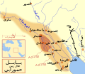
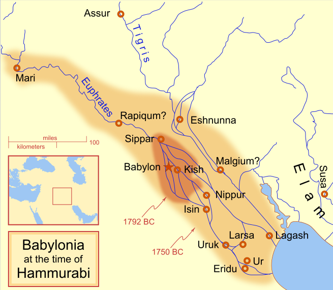
A locator map of Hammurabi's Babylonia, showing the Babylonian territory upon his ascension in 1792 BC and upon his death in 1750 BC. The river courses and coastline are those of that time period -- in general, they are not the modern rivers or coastlines. This is a Mercator projection, with north in its usual position

There is some question to what degree the cities of Nineveh, Tuttul, and Assur were under Babylonian authority. While in his introduction to his code of laws, Hammurabi claims lordship over these cities, Roaf does not include any of these in his map, upon which this map is based, and Chevalas states that "Assur and Nineveh were held for a very few years" (p. 155). Therefore, I have not included them as under Hammurabi's control in 1750 BC.
تاريخ
مصدر عمل شخصى
مؤلف MapMaster
إصدارات أخرى

[تعديل]

See also

References

  • Bjorklund, Oddvar; Holmboe, Haakon; Rohr, Anders (1970) Historical Atlas of the World, Barnes & Noble, NY, SBN: 389-00253-4.
  • Chavalas, Mark W.; K. Lawson Younger (2003) Mesopotamia and the Bible, Continuum International Publishing Group, ISBN 978-0567082312.
  • Hammond World Atlas Corporation (2007) Historical World Atlas, ISBN 9-780843-71391-6
  • Roaf, M. (1990) Cultural Atlas of Mesopotamia and the ancient Near East, Oxford: Facts on File. (In general, the basis for the ancient river courses and ancient coastline).
  • Van De Mieroop, Marc (2005). King Hammurabi of Babylon: A Biography. Blackwell Publishing. ISBN 1405126604

الترخيص

أنا، صاحب حقوق التأليف والنشر لهذا العمل، أنشر هذا العمل تحت الرخص التالية:
GNU head يسمح بنسخ و توزيع و / أو تعديل الوثيقه دى تحت شروط رخصة جنو للوثائق الحره، الإصدار 1.2 أو أى إصدار تنشره مؤسسة البرمجيات الحره؛ بدون أقسام ثابته و بدون نصوص أغلفه أماميه و بدون نصوص أغلفه خلفيه. نسخه من الرخصه متضمنه ف قسم اسمه GNU Free Documentation License.
w:ar:مشاع إبداعي
نسبه ل مشاركه زي
This file is licensed under the Creative Commons Attribution-Share Alike 4.0 International, 3.0 Unported, 2.5 Generic, 2.0 Generic and 1.0 Generic license.
إنت حر:
  • فى المشاركه – علشان نسخ و توزيع و بث العمل
  • إنك تمزج – فى تكييف العمل
بالشروط دى:
  • نسبه ل – لازم يتنسب العمل للى مألفه بشكل مناسب و توفير رابط للرخصه وتحديد اذا حصلت تغييرات. ممكن ده يتعمل بأى طريقه معقوله، لكن مش بطريقه تشير ان مانح الرخصه بيوافقك على الاستعمال.
  • مشاركه زي – لو عدت إنتاج المواد أو غيرت فيها، لازم تنشر مساهماتك اللى جايه من الأصل تحت ترخيص الأصل نفسه أو تحت ترخيص متوافق معاه.
اختار الرخصه اللى تناسبك.

الشروحات

أضف شرحاً من سطر واحد لما يُمثِّله هذا الملف
Babylonian

العناصر المصورة في هذا الملف

يُصوِّر العربية

18 فبراير 2008

نوع الوسائط العربية

image/svg+xml

تاريخ الفايل

اضغط على الساعه/التاريخ علشان تشوف الفايل زى ما كان فى الوقت ده.

(آخر | اول) شوف (أحدث 10 | ) (10 | 20 | 50 | 100 | 250 | 500)
الساعه / التاريخصورة صغيرةابعاديوزرتعليق
دلوقتي09:14، 21 ابريل 2013تصغير للنسخة بتاريخ 09:14، 21 ابريل 2013655 × 570 (183 كيلوبايت)CitypeekCleanup of file. Valid SVG now.
19:06، 27 ابريل 2010تصغير للنسخة بتاريخ 19:06، 27 ابريل 2010655 × 570 (168 كيلوبايت)DieBucheremoved border
15:05، 30 يوليه 2009تصغير للنسخة بتاريخ 15:05، 30 يوليه 2009661 × 580 (317 كيلوبايت)Amit6Some nodes changed.
23:24، 3 مارس 2008تصغير للنسخة بتاريخ 23:24، 3 مارس 2008661 × 580 (163 كيلوبايت)MapMasterAdded city-state, moved Sippar, minor other changes based on recent Kassite map
16:06، 23 فبراير 2008تصغير للنسخة بتاريخ 16:06، 23 فبراير 2008661 × 580 (161 كيلوبايت)MapMasterAdded 1 city, added name for 1 city
03:29، 21 فبراير 2008تصغير للنسخة بتاريخ 03:29، 21 فبراير 2008661 × 580 (159 كيلوبايت)MapMaster"blurred" the territory outlines
23:25، 20 فبراير 2008تصغير للنسخة بتاريخ 23:25، 20 فبراير 2008661 × 580 (155 كيلوبايت)MapMasterChanges made based on info from ''Mesopotamia and the Bible''
02:03، 19 فبراير 2008تصغير للنسخة بتاريخ 02:03، 19 فبراير 2008663 × 580 (156 كيلوبايت)MapMasterFixed an error on my part
21:12، 18 فبراير 2008تصغير للنسخة بتاريخ 21:12، 18 فبراير 2008332 × 292 (156 كيلوبايت)MapMastersome minor edits
19:19، 18 فبراير 2008تصغير للنسخة بتاريخ 19:19، 18 فبراير 2008332 × 293 (154 كيلوبايت)MapMasterremoved unrenderable bmp
(آخر | اول) شوف (أحدث 10 | ) (10 | 20 | 50 | 100 | 250 | 500)

استخدام الفايل

ال1 صفحة دى فيها وصله للفايل ده:

استخدام الملف العام

الويكيات التانيه دى بتستخدم الفايل ده:

اعرض استخدام عام اكتر للملف ده.

بيانات ميتا

{{bottomLinkPreText}} {{bottomLinkText}}
ملف:Hammurabi's Babylonia 1.svg
Listen to this article

This browser is not supported by Wikiwand :(
Wikiwand requires a browser with modern capabilities in order to provide you with the best reading experience.
Please download and use one of the following browsers:

This article was just edited, click to reload
This article has been deleted on Wikipedia (Why?)

Back to homepage

Please click Add in the dialog above
Please click Allow in the top-left corner,
then click Install Now in the dialog
Please click Open in the download dialog,
then click Install
Please click the "Downloads" icon in the Safari toolbar, open the first download in the list,
then click Install
{{::$root.activation.text}}

Install Wikiwand

Install on Chrome Install on Firefox
Don't forget to rate us

Tell your friends about Wikiwand!

Gmail Facebook Twitter Link

Enjoying Wikiwand?

Tell your friends and spread the love:
Share on Gmail Share on Facebook Share on Twitter Share on Buffer

Our magic isn't perfect

You can help our automatic cover photo selection by reporting an unsuitable photo.

This photo is visually disturbing This photo is not a good choice

Thank you for helping!


Your input will affect cover photo selection, along with input from other users.

X

Get ready for Wikiwand 2.0 🎉! the new version arrives on September 1st! Don't want to wait?